So Cool! WOW!
So cool! WOW!

More Posts from Elvaltal and Others
Launch was delayed. Tentatively scheduled for Thursday 12/15 at 826 AM EST. Lots more information available through www.nasa.gov/cygnss . More great satellite info upcoming!
Eight Small Satellites Will Give Us a New Look Inside Hurricanes

The same GPS technology that helps people get where they’re going in a car will soon be used in space in an effort to improve hurricane forecasting. The technology is a key capability in a NASA mission called the Cyclone Global Navigation Satellite System (CYGNSS).

The CYGNSS mission, led by the University of Michigan, will use eight micro-satellite observatories to measure wind speeds over Earth’s oceans, increasing the ability of scientists to understand and predict hurricanes. Each microsatellite observatory will make observations based on the signals from four GPS satellites.

The CYGNSS microsatellite observatories will only receive signals broadcast directly to them from GPS satellites already orbiting the Earth and the reflection of the same satellite’s signal reflected from the Earth’s surface. The CYGNSS satellites themselves will not broadcast.

The use of eight microsatellite observatories will decrease the revisit time as compared with current individual weather satellites. The spacecraft will be deployed separately around the planet, with successive satellites passing over the same region every 12 minutes.
This will be the first time that satellites can peer through heavy tropical rainfall into the middle of hurricanes and predict how intense they are before and during landfall.

As the CYGNSS and GPS constellations orbit around the Earth, the interaction of the two systems will result in a new image of wind speed over the entire tropics every few hours, compared to every few days for a single satellite.

Another advantage of CYGNSS is that its orbit is designed to measure only in the tropics…where hurricanes develop and are most often located. The focus on tropical activity means that the instruments will be able to gather much more useful data on weather systems exclusively found in the tropics. This data will ultimately be used to help forecasters and emergency managers make lifesaving decisions.
Watch Launch!

Launch of CYGNSS is scheduled for 8:24 a.m. EST on Monday, Dec. 12 from our Kennedy Space Center in Florida. CYGNSS will launch aboard an Orbital ATK Pegasus XL rocket, which will be deployed from Orbital’s “Stargazer” L-1011 carrier aircraft.
Pegasus is a winged, three-stage solid propellant rocket that can launch a satellite into low Earth orbit. How does it work? Great question!

After takeoff, the aircraft (which looks like a commercial airplane..but with some special quirks) flies to about 39,000 feet over the ocean and releases the rocket.

After a five-second free fall in a horizontal position, the Pegasus first stage ignites. The aerodynamic lift, generated by the rocket’s triangle-shaped wing, delivers the payload into orbit in about 10 minutes.
Pegasus is used to deploy small satellites weighing up to 1,000 pounds into low Earth orbit.
Watch live coverage HERE.
Make sure to follow us on Tumblr for your regular dose of space: http://nasa.tumblr.com
Solar System: Things to Know This Week
This week, we’re looking at MAVEN’s exploration of Mars, the Orionid meteor showers, Mercury’s “great valley” and more.

1. Celebrating MAVEN
MAVEN, the Mars Atmospheric and Volatile Evolution, was the second mission selected for our Mars Scout program and the first to explore the planet’s upper atmosphere . It launched on November 18, 2013 and entered orbit around Mars on September 21, 2014.
+ MAVEN Quick Facts

2. Jupiter Moon Dance
This time-lapse sequence of Hubble Space Telescope images shows Jupiter’s moon Europa as it moved across the planet’s face over the course of 19 minutes. Europa is at the bottom center on Jupiter’s disk, the Great Red Spot to the left and Europa’s shadow to its right. The video was created by combining six snapshots taken in ultraviolet light with Hubble’s Wide Field Camera 3.
+ Learn more

3. The Orionid Meteor Shower
Orionid shower peaks November 28. Look for the constellation Orion in the Southeast sky by 9 p.m. Using binoculars, look for the Orion Nebula.

4. Comet Warming Up!!
Comet 45P/Honda-Mrkos-Pajdu áková will brighten to expected stunning binocular visibility in mid to late December, but is near Venus on November 23rd.
+ Track the Comet

5. Mercury’s “Great Valley”
A newly discovered “great valley” in the southern hemisphere of Mercury provides more evidence that the planet closest to the sun is shrinking. Using stereo images from our MESSENGER spacecraft to create a high-resolution map, scientists have discovered that revealed the broad valley – more than 620 miles (1,000 kilometers) long – extending into the Rembrandt basin, one of the largest and youngest impact basins on Mercury. About 250 miles (400 kilometers) wide and 2 miles (3 kilometers) deep, Mercury’s great valley is smaller than Mars’ Valles Marineris, but larger than North America’s Grand Canyon and wider and deeper than the Great Rift Valley in East Africa.
+ Learn more
Discover the full list of 10 things to know about our solar system this week HERE.
Make sure to follow us on Tumblr for your regular dose of space: http://nasa.tumblr.com
You've got that right!! When thunder roars go indoors!

Talk about a wakeup call! I live near a camping area so I hope this never happens. Wow

Bled, Slovenia
New satellite technology in action!!! Woo hoo!

One of the first images from NOAA’s new satellite, the GOES 16. Spectacular!
Supermoon!
WOW! It’s Supermoon night, and yep, it’s ‘big,’ well, relatively speaking. Have to watch out for big high tides along the southern New England coast from 11/14-17 with any onshore wind flow. We’re watching it!
Found this photo on my Twitter feed. It’s, well, SUPER! With proper credit, of course.

Credit: @brandonsmith_wx , photo taken 11/13/16 in State College, PA USA
WOW! Gorgeous!

Aurora Borealis /Northern Lights by grynetvalp
Awwww! Sweet Pabu!! 😊
Guess what it is, Pabu!

Pabu: Smells like a pointer…

Pabu: Feels like a pointer…

Pabu: Sounds like a pointer…

Pabu: Is it a dinner time?
Wow is right!! Great composite! #lightning

Сomposite shot of a thunderstorm in Gurgaon (India) on April 5, 2017. Here are 89 photos! WOW! credit: Jan Wellmann
Beautiful! #milkyway
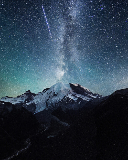
Shooting star over Mt. Rainer, Washington | by Tanner Stewart
-
 rlbmut-06 liked this · 1 year ago
 -
 l70l liked this · 2 years ago
 -
 this-is-natural reblogged this · 4 years ago
 -
this-is-natural liked this · 4 years ago
-
 wj630824 liked this · 4 years ago
 -
 mikayla-scott reblogged this · 4 years ago
 -
mikayla-scott liked this · 4 years ago
-
 simplemanwithcomplexthoughts liked this · 4 years ago
 -
 babursohail liked this · 5 years ago
 -
 king0frand0mness liked this · 5 years ago
 -
 wooflodog liked this · 5 years ago
 -
 davew52 liked this · 5 years ago
 -
 freedomforeverybody118 liked this · 5 years ago
 -
 capitalpillar reblogged this · 5 years ago
 -
 las-manos-sucias reblogged this · 5 years ago
 -
 dolliewrld liked this · 5 years ago
 -
 abominenturme-blog liked this · 5 years ago
 -
 jos-94 reblogged this · 6 years ago
 -
 s-cribe reblogged this · 6 years ago
 -
s-cribe liked this · 6 years ago
-
 moonharithelastmoonneko-blog liked this · 6 years ago
 -
 uptowngirl328 liked this · 6 years ago
 -
djjjjj322 reblogged this · 7 years ago
-
 tomatoesandpears liked this · 7 years ago