Solar System: Things To Know This Week
Solar System: Things to Know This Week
Our social media accounts will help you explore our world, the solar system and beyond.

1. The Flagship Fleet
Start with our flagship accounts, where you can keep up with all the latest news and be a part of the conversation.
Twitter: https://twitter.com/nasa
Facebook: https://www.facebook.com/NASA/
Instagram: https://www.instagram.com/nasa/
Tumblr: http://nasa.tumblr.com/
Pinterest: https://www.pinterest.com/nasa/
2. Your Galactic Neighborhood
Follow our Planetary Science Division to keep up with all the hardworking robots exploring the wild frontiers of our solar system.
Twitter: https://twitter.com/NASASolarSystem
Facebook: https://www.facebook.com/nasasolarsystem
Instagram: https://www.instagram.com/nasasolarsystem/
3. Mission Space
From the sun to Pluto and points in between, many NASA missions share their science on a variety of social platforms.
Twitter: https://www.nasa.gov/socialmedia#missions

4. NASA’s History
Need some nostalgia in your feed? Learn the history of our exploration of our home planet, our solar system and beyond.
Twitter: https://twitter.com/NASAhistory
Facebook: https://www.facebook.com/NASAHistoryOffice
5. Kids in Space
Find fun stuff for kids, parents and anyone who likes space and Earth science, including games, hands-on projects and fun facts.
Twitter: https://twitter.com/nasaspaceplace
Facebook: https://www.facebook.com/nasaspaceplace

6. The Big Picture
Our photographers take their cameras to some interesting places around the planet.
Flickr: https://www.flickr.com/photos/nasahqphoto/
7. Star Watch
This is a great way to follow our missions that study the sun, Earth and space itself as elements of a interconnected system.
Twitter https://twitter.com/NASASunEarth

8. NASA People
Want to know what it's like to work for us? Learn about the science and adventures of astronauts, scientists and engineers exploring space.
View the List: https://www.nasa.gov/socialmedia#people
9. NASA Earth
Our planet is changing, and NASA Earth is on it, using the vantage point of space to increase our understanding of Earth and improve lives.
Twitter: https://twitter.com/nasaearth
Facebook: https://www.facebook.com/nasaearth
10. Craving More?
Visit us at: https://www.nasa.gov/socialmedia
for a listing of the agency’s current social media accounts.
Discover more lists of 10 things to know about our solar system HERE.
Follow us on Tumblr for your regular dose of space: http://nasa.tumblr.com
More Posts from Nasa and Others
Space Station Research: Observing Earth
Each month, we highlight a different research topic on the International Space Station. In April, our focus is how the space station provides a platform for studying the Earth.
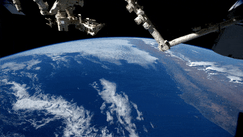
You might wonder how a laboratory 250 miles above Earth could help us study and observe our home planet, but the space station actually gives us a unique view of the blue marble we call home.
The space station is part of a fleet of Earth remote-sensing platforms to develop a scientific understanding of Earth’s systems and its response to natural or human-induced changes and to improve prediction of climate, weather and natural hazards. Unlike automated remote-sensing platforms, the space station has a human crew, a low-orbit altitude and orbital parameters that provide variable views and lighting. Crew members have the ability to collect unscheduled data of an unfolding event, like severe weather, using handheld digital cameras.

The Cupola, seen above, is one of the many ways astronauts aboard the space station are able to observe the Earth. This panoramic control tower allows crew members to view and guide operations outside the station, like the station’s robotic arm.

The space station also has an inclined, sun-asynchronous orbit, which means that it travels over 90% of the inhabited surface of the Earth, and allows for the station to pass over ground locations at different times of the day and night. This perspective is different and complimentary to other orbiting satellites.
The space station is also home to a few Earth-observing instruments, including:

The ISS-RapidScat monitors ocean winds for climate research, weather prediction and hurricane science. This vantage point gives scientists the first near-global direct observations of how ocean winds can vary over the course of the day, while adding extra eyes in the tropics and mid-latitudes to track the formation and movement of tropical cyclones.

CATS (Cloud-Aerosol Transport System) is a laser instrument that measures clouds and airborne particles such as pollution, mineral dust and smoke. Improving cloud data allows scientists to create more accurate climate models, which in turn, will improve air quality forecasts and health risk alerts.

In late 2016, we will launch Stratospheric Aerosol and Gas Experiment III (SAGE III). This experiment will measure ozone and other gases in the atmosphere to help scientists assess how the ozone layer is recovering.

Want to observe the Earth from a similar vantage point? You can thanks to our High Definition Earth-Viewing System (HDEV). This experiment is mounted on the exterior of the space station and includes several commercial HD video cameras aimed at the Earth.
Make sure to follow us on Tumblr for your regular dose of space: http://nasa.tumblr.com
What are CubeSats?
CubeSats are a class of research spacecraft called nanosatellites. They provide low-cost opportunities for small satellite payloads to fly on rockets planned for upcoming launches. Small satellites, including CubeSats, are playing an increasingly larger role in exploration, technology demonstration, scientific research and educational investigations here at NASA.

Fourteen miniature satellites were deployed from the International Space Station earlier this week. Two of the CubeSats were Danish and have communication and ship signal tracking capabilities. The remaining are Dove satellites from Planet Labs and will take images of Earth from space.
On Thursday, Oct. 8, thirteen CubeSats are scheduled to launch aboard a United Launch Alliance Atlas V rocket at 8:49 a.m. EDT. Watch live on NASA TV starting at 8:29 a.m. http://www.nasa.gov/nasatv
To learn more about tomorrow’s launch, watch NASA Television today, Oct. 7 at 1 p.m. and 2 p.m. EDT. The briefings will highlight the growing importance of CubeSats in space exploration.
Make sure to follow us on Tumblr for your regular dose of space: http://nasa.tumblr.com
21 Years of Amazing Earth Imagery
On April 29, 1999, NASA Earth Observatory started delivering science stories and imagery to the public through the Internet. Today, we turn 21! So much has changed in the past two decades...
One of the most notable changes is the way we view our home planet. Check out some of the beautiful imagery of our planet over the past 21 years.
2000: Pine Island Glacier

Most people will never see Pine Island Glacier in person. Located near the base of the Antarctic Peninsula—the “thumb” of the continent—the glacier lies more than 2,600 kilometers (1,600 miles) from the tip of South America. That’s shorter than a cross-country flight from New York to Los Angeles, but there are no runways on the glacier and no infrastructure. Only a handful of scientists have ever set foot on its ice.
This animation shows a wide view of Pine Island Glacier and the long-term retreat of its ice front. Images were acquired by the Moderate Resolution Imaging Spectroradiometer (MODIS) on our Terra satellite from 2000 to 2019. Notice that there are times when the front appears to stay in the same place or even advance, though the overall trend is toward retreat. Read more.
2002: The Blue Marble

In February 2002, Earth Observatory published this “blue marble” image based on the most detailed collection of true-color imagery of the entire Earth at that time. Using a collection of satellite-based observations, scientists and visualizers stitched together months of observations of the land surface, oceans, sea ice and clouds into a seamless, true-color mosaic of every square kilometer (.386 square mile) of our planet. Most of the information contained in this image came from Moderate Resolution Imaging Spectrometer (MODIS), illustrating the instrument's outstanding capacity to act as an integrated tool for observing a variety of terrestrial, oceanic and atmospheric features of the Earth. Read more.
2009: Tsauchab River Bed

The Tsauchab River is a famous landmark for the people of Namibia and tourists. Yet few people have ever seen the river flowing with water. In December 2009, an astronaut on the International Space Station caught this glimpse of the Tsauchab River bed jutting into the sea of red dunes. It ends in a series of light-colored, silty mud holes on the dry lake floor.
Like several other rivers around the Namib Desert, the Tsauchab brings sediment down from the hinterland toward the coastal lowland. This sediment is then blown from the river beds, and over tens of millions of years it has accumulated as the red dunes of the Namib Sand Sea. Read more.
2012: Manning Island and Foxe Basin, Canada

Although it may look like a microscope’s view of a thin slice of mineral-speckled rock, this image was actually acquired in space by the Earth Observing-1 satellite in July 2012. It shows a small set of islands and a rich mixture of ice in Foxe Basin, the shallow northern reaches of Hudson Bay.
The small and diverse sizes of the ice floes indicate that they were melting. The darkest colors in the image are open water. Snow-free ice appears gray, while snow-covered ice appears white. The small, dark features on many of the floes are likely melt ponds. Read more.
2013: A Lava Lamp Look at the Atlantic

Stretching from tropical Florida to the doorstep of Europe, this river of water carries a lot of heat, salt, and history. The Gulf Stream is an important part of the global ocean conveyor belt that moves water and heat across the North Atlantic from the equator toward the poles. It is one of the strongest currents on Earth, and one of the most studied.
This image shows a small portion of the Gulf Stream as it appears in infrared imagery. Data for this image was acquired on April 9, 2013, by the Thermal Infrared Sensor (TIRS) on the Landsat 8 satellite. TIRS observes in wavelengths of 10.9 micrometers and 12.0 micrometers. The image above is centered at 33.06° North latitude, 73.86° West longitude, about 500 kilometers (300 miles) east of Charleston, South Carolina. Read more.
2016: Curious Ensemble of Wonderful Features

When John Wesley Powell explored the Colorado River in 1869, he made the first thorough survey of one of the last blank spots on the map. The expedition began in May at Green River, Wyoming, and ended three months later at the confluence of the Colorado and Virgin Rivers in present-day Nevada.
About two months into their journey, the nine men of the expedition found themselves in Glen Canyon. As the men traveled along the serpentine river channel, they encountered what Powell later described in Canyons of Colorado as a “curious ensemble of wonderful features.”
From above, the view of Glen Canyon is equally arresting. In 2016, an astronaut aboard the International Space Station took several photographs that were combined to make a long mosaic. The water has an unnatural shade of blue because of sunglint, an optical phenomenon that occurs when sunlight reflects off the surface of water at the same angle that a camera views it. Click here to see the long mosaic.
2019: Lena Delta Shakes Off Water

For most of the year, the Lena River Delta—a vast wetland fanning out from northeast Siberia into the Arctic Ocean—is either frozen over and barren or thawed out and lush. Only briefly will you see it like this.
After seven months encased in snow and ice, the delta emerges for the short Arctic summer. The transition happens fast. The animation above, composed of images from the Moderate Resolution Imaging Spectroradiometer (MODIS) on our Aqua satellite, shows the transformation from June 3-10, 2019. Read more.
2020: Making Waves in the Andaman Sea

When tides, currents and gravity move water masses over seafloor features, they can create wave actions within the ocean. Oceanographers began studying these internal waves from ships in the 1960s, and the modern era of satellites has made it possible to see them on a grand scale. The Operational Land Imager (OLI) on Landsat 8 captured these images of the Andaman Sea on November 29, 2019. The reflection of the Sun on the ocean—sunglint—helps make the internal waves visible.
Internal waves form because the ocean is layered. Deep water tends to be colder, denser and saltier, while shallower water is often warmer, lighter and fresher. The differences in density and salinity cause layers of the ocean to behave like different fluids. When tides, currents, gravity and Earth’s rotation move these different water masses over seafloor formations (such as ridges or canyons), they create waves within the sea. Read more.
These images were taken from NASA Earth Observatory!
Interested in receiving Earth Observatory's Images of the Day? Subscribe to our newsletters or RSS feeds.
Make sure to follow us on Tumblr for your regular dose of space: http://nasa.tumblr.com.
Sixty Years of Exploration, Innovation, and Discovery!

Exactly sixty years ago today, we opened our doors for the first time. And since then, we have opened up a universe of discovery and innovation.
There are so many achievements to celebrate from the past six decades, there’s no way we can go through all of them. If you want to dive deeper into our history of exploration, check out NASA: 60 Years and Counting.
In the meantime, take a moonwalk down memory lane with us while we remember a few of our most important accomplishments from the past sixty years!

In 1958, President Eisenhower signed the National Aeronautics and Space Act, which effectively created our agency. We officially opened for business on October 1.
To learn more about the start of our space program, watch our video: How It All Began.

Alongside the U.S. Air Force, we implemented the X-15 hypersonic aircraft during the 1950s and 1960s to improve aircraft and spacecraft.
The X-15 is capable of speeds exceeding Mach 6 (4,500 mph) at altitudes of 67 miles, reaching the very edge of space.
Dubbed the “finest and most productive research aircraft ever seen,” the X-15 was officially retired on October 24, 1968. The information collected by the X-15 contributed to the development of the Mercury, Gemini, Apollo, and Space Shuttle programs.
To learn more about how we have revolutionized aeronautics, watch our Leading Edge of Flight video.

On July 20, 1969, Neil Armstrong and Buzz Aldrin became the first humans to walk on the moon. The crew of Apollo 11 had the distinction of completing the first return of soil and rock samples from beyond Earth.
Astronaut Gene Cernan, during Apollo 17, was the last person to have walked on the surface of the moon. (For now!)
The Lunar Roving Vehicle was a battery-powered rover that the astronauts used during the last three Apollo missions.
To learn more about other types of technology that we have either invented or improved, watch our video: Trailblazing Technology.

Our long-term Earth-observing satellite program began on July 23, 1972 with the launch of Landsat 1, the first in a long series (Landsat 9 is expected to launch in 2020!) We work directly with the U.S. Geological Survey to use Landsat to monitor and manage resources such as food, water, and forests.
Landsat data is one of many tools that help us observe in immense detail how our planet is changing. From algae blooms to melting glaciers to hurricane flooding, Landsat is there to help us understand our own planet better.
Off the Earth, for the Earth.
To learn more about how we contribute to the Earth sciences, watch our video: Home, Sweet Home.

Space Transportation System-1, or STS-1, was the first orbital spaceflight of our Space Shuttle program.
The first orbiter, Columbia, launched on April 12, 1981. Over the next thirty years, Challenger, Discovery, Atlantis, and Endeavour would be added to the space shuttle fleet.
Together, they flew 135 missions and carried 355 people into space using the first reusable spacecraft.

On January 16, 1978, we selected a class of 35 new astronauts--including the first women and African-American astronauts.
And on June 18, 1983, Sally Ride became the first American woman to enter space on board Challenger for STS-7.
To learn more about our astronauts, then and now, watch our Humans in Space video.

Everybody loves Hubble! The Hubble Space Telescope was launched into orbit on April 24, 1990, and has been blowing our minds ever since.
Hubble has not only captured stunning views of our distant stars and galaxies, but has also been there for once-in-a-lifetime cosmic events. For example, on January 6, 2010, Hubble captured what appeared to be a head-on collision between two asteroids--something no one has ever seen before.
In this image, Hubble captures the Carina Nebula illuminating a three-light-year tall pillar of gas and dust.
To learn more about how we have contributed to our understanding of the solar system and beyond, watch our video: What’s Out There?

Cooperation to build the International Space Station began in 1993 between the United States, Russia, Japan, and Canada.
The dream was fully realized on November 2, 2000, when Expedition 1 crew members boarded the station, signifying humanity’s permanent presence in space!
Although the orbiting lab was only a couple of modules then, it has grown tremendously since then!
To learn more about what’s happening on the orbiting outpost today, visit the Space Station page.

We have satellites in the sky, humans in orbit, and rovers on Mars. Very soon, we will be returning humankind to the Moon, and using it as a platform to travel to Mars and beyond.
And most importantly, we bring the universe to you.
What are your favorite NASA moments? We were only able to share a few of ours here, but if you want to learn about more important NASA milestones, check out 60 Moments in NASA History or our video, 60 Years in 60 Seconds.
Make sure to follow us on Tumblr for your regular dose of space: http://nasa.tumblr.com.
What are Phytoplankton and Why Are They Important?
Breathe deep… and thank phytoplankton.
Why? Like plants on land, these microscopic creatures capture energy from the sun and carbon from the atmosphere to produce oxygen.

Phytoplankton are microscopic organisms that live in watery environments, both salty and fresh. Though tiny, these creatures are the foundation of the aquatic food chain. They not only sustain healthy aquatic ecosystems, they also provide important clues on climate change.
Let’s explore what these creatures are and why they are important for NASA research.
Phytoplankton are diverse
Phytoplankton are an extremely diversified group of organisms, varying from photosynthesizing bacteria, e.g. cyanobacteria, to diatoms, to chalk-coated coccolithophores. Studying this incredibly diverse group is key to understanding the health - and future - of our ocean and life on earth.

Their growth depends on the availability of carbon dioxide, sunlight and nutrients. Like land plants, these creatures require nutrients such as nitrate, phosphate, silicate, and calcium at various levels. When conditions are right, populations can grow explosively, a phenomenon known as a bloom.

Phytoplankton blooms in the South Pacific Ocean with sediment re-suspended from the ocean floor by waves and tides along much of the New Zealand coastline.
Phytoplankton are Foundational
Phytoplankton are the foundation of the aquatic food web, feeding everything from microscopic, animal-like zooplankton to multi-ton whales. Certain species of phytoplankton produce powerful biotoxins that can kill marine life and people who eat contaminated seafood.

Phytoplankton are Part of the Carbon Cycle
Phytoplankton play an important part in the flow of carbon dioxide from the atmosphere into the ocean. Carbon dioxide is consumed during photosynthesis, with carbon being incorporated in the phytoplankton, and as phytoplankton sink a portion of that carbon makes its way into the deep ocean (far away from the atmosphere).
Changes in the growth of phytoplankton may affect atmospheric carbon dioxide concentrations, which impact climate and global surface temperatures. NASA field campaigns like EXPORTS are helping to understand the ocean's impact in terms of storing carbon dioxide.

Phytoplankton are Key to Understanding a Changing Ocean
NASA studies phytoplankton in different ways with satellites, instruments, and ships. Upcoming missions like Plankton, Aerosol, Cloud, ocean Ecosystem (PACE) - set to launch Jan. 2024 - will reveal interactions between the ocean and atmosphere. This includes how they exchange carbon dioxide and how atmospheric aerosols might fuel phytoplankton growth in the ocean.
Information collected by PACE, especially about changes in plankton populations, will be available to researchers all over the world. See how this data will be used.
The Ocean Color Instrument (OCI) is integrated onto the PACE spacecraft in the cleanroom at Goddard Space Flight Center. Credit: NASA
Human Expansion Across Solar System
On this day in 1972, two NASA astronauts landed on the Moon. Now, 45 years later, we have been instructed to return to the lunar surface.
Today at the White House, President Trump signed the Space Policy Directive 1, a change in national space policy that provides for a U.S.-led program with private sector partners for a human return to the Moon, followed by missions to Mars and beyond.

Among other dignitaries on hand for the signing, were NASA astronauts Sen. Harrison “Jack” Schmitt, Buzz Aldrin, Peggy Whitson and Christina Koch.
Schmitt landed on the moon 45 years to the minute that the policy directive was signed as part of our Apollo 17 mission, and is the most recent living person to have set foot on our lunar neighbor.

Above, at the signing ceremony instructing us to send humans back to the lunar surface, Schmitt shows First Daughter Ivanka Trump the Moon sample he collected in 1972.
The effort signed today will more effectively organize government, private industry and international efforts toward returning humans on the Moon, and will lay the foundation that will eventually enable human exploration of Mars.
To learn more, visit: https://www.nasa.gov/press-release/new-space-policy-directive-calls-for-human-expansion-across-solar-system
Make sure to follow us on Tumblr for your regular dose of space: http://nasa.tumblr.com.
Three Ways to Travel at (Nearly) the Speed of Light

One hundred years ago, Einstein’s theory of general relativity was supported by the results of a solar eclipse experiment. Even before that, Einstein had developed the theory of special relativity — a way of understanding how light travels through space.
Particles of light — photons — travel through a vacuum at a constant pace of more than 670 million miles per hour.

All across space, from black holes to our near-Earth environment, particles are being accelerated to incredible speeds — some even reaching 99.9% the speed of light! By studying these super fast particles, we can learn more about our galactic neighborhood.
Here are three ways particles can accelerate:
1) Electromagnetic Fields!
Electromagnetic fields are the same forces that keep magnets on your fridge! The two components — electric and magnetic fields — work together to whisk particles at super fast speeds throughout the universe. In the right conditions, electromagnetic fields can accelerate particles at near-light-speed.

We can harness electric fields to accelerate particles to similar speeds on Earth! Particle accelerators, like the Large Hadron Collider and Fermilab, use pulsed electromagnetic fields to smash together particles and produce collisions with immense amounts of energy. These experiments help scientists understand the Big Bang and how it shaped the universe!
2) Magnetic Explosions!

Magnetic fields are everywhere in space, encircling Earth and spanning the solar system. When these magnetic fields run into each other, they can become tangled. When the tension between the crossed lines becomes too great, the lines explosively snap and realign in a process known as magnetic reconnection. Scientists suspect this is one way that particles — for example, the solar wind, which is the constant stream of charged particles from the Sun — are sped up to super fast speeds.

When magnetic reconnection occurs on the side of Earth facing away from the Sun, the particles can be hurled into Earth’s upper atmosphere where they spark the auroras.
3) Wave-Particle Interactions!

Particles can be accelerated by interactions with electromagnetic waves, called wave-particle interactions. When electromagnetic waves collide, their fields can become compressed. Charged particles bounce back and forth between the waves, like a ball bouncing between two merging walls. These types of interactions are constantly occurring in near-Earth space and are responsible for damaging electronics on spacecraft and satellites in space.

Wave-particle interactions might also be responsible for accelerating some cosmic rays from outside our solar system. After a supernova explosion, a hot, dense shell of compressed gas called a blast wave is ejected away from the stellar core. Wave-particle interactions in these bubbles can launch high-energy cosmic rays at 99.6% the speed of light.
Make sure to follow us on Tumblr for your regular dose of space: http://nasa.tumblr.com.
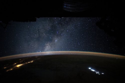
“We saw to the edge of all there is—
So brutal and alive it seemed to comprehend us back.”
-Tracy K. Smith, US Poet Laureate
Some pictures are worth a thousand words and some a thousand thoughts. On Jan. 31, astronaut Christina Koch shared this emotional view and quote from the International Space Station. Enjoy.
Make sure to follow us on Tumblr for your regular dose of space: http://nasa.tumblr.com

These three towers are only a small portion of the massive Eagle Nebula.
Known as the “Pillars of Creation,” the beautiful tendrils of cosmic dust and gas are giving birth to new stars, buried within their spires. This iconic image only shows a stretch of about four or five light-years … while the whole nebula itself spans about 70 by 55 light-years.
Learn more about Hubble’s celebration of Nebula November and see new nebula images, here.
You can also keep up with Hubble on Twitter, Instagram, Facebook, and Flickr!
Image credits: NASA, ESA and the Hubble Heritage Team (STScI/AURA)
🔎 Lava Lake Discovery
🌋 Raikoke Volcano Eruption
🔥 Uptick in Amazon Fire Activity
2019 brought many memorable events on Planet Earth, and NASA satellites and astronauts captured a lot of the action! From new discoveries to tracking natural events and capturing amazing scenery, here are a few highlights from around the globe.
Read more about the images in this video, here.
-
 melpomenismask reblogged this · 5 years ago
 -
melpomenismask liked this · 5 years ago
-
 ploorm liked this · 5 years ago
 -
 boostarz liked this · 5 years ago
 -
 cantineoqueteveo-concurso liked this · 6 years ago
 -
 growthhackingfrance liked this · 6 years ago
 -
 antoniovchanal reblogged this · 6 years ago
 -
 sillytravelerhear-blog liked this · 6 years ago
 -
antoniovchanal reblogged this · 7 years ago
-
antoniovchanal liked this · 7 years ago
-
antoniovchanal reblogged this · 7 years ago
-
 fahidbaby reblogged this · 7 years ago
 -
fahidbaby liked this · 7 years ago
-
 asknimesh liked this · 7 years ago
 -
 blog-dzepxich liked this · 7 years ago
 -
 andreagiavara liked this · 7 years ago
 -
 sparechangeofheart liked this · 8 years ago
 -
 gravityinglass reblogged this · 8 years ago
 -
 melodiousramblings reblogged this · 8 years ago
 -
 tracybatwinas reblogged this · 8 years ago
 -
 jennifornow reblogged this · 8 years ago
 -
 brokentowels reblogged this · 8 years ago
 -
 blogboosterpro-blog liked this · 8 years ago
 -
 socialmediabloggers-blog liked this · 8 years ago
 -
 oh-ganesson liked this · 8 years ago
 -
 alxxandxr reblogged this · 8 years ago
 -
 myspacetaggart-blog liked this · 8 years ago
 -
 sstarsapphic reblogged this · 8 years ago
 -
 erikaii liked this · 8 years ago
 -
 thelastcity01 liked this · 8 years ago
 -
 lefthandwingman reblogged this · 8 years ago
 -
 betofogo-blog liked this · 8 years ago
 -
 howaboutnico reblogged this · 8 years ago
 -
 profwoodtauxvigne-blog reblogged this · 8 years ago
 -
tracybatwinas liked this · 8 years ago
Explore the universe and discover our home planet with the official NASA Tumblr account
1K posts