@tinyscoop: What's The Strangest Experiment You've Ever Had To Carry Out Up There?
@tinyscoop: What's the strangest experiment you've ever had to carry out up there?
More Posts from Nasa and Others
Our pale blue dot, planet Earth, is seen in this video captured by NASA astronaut Jack Fischer from his unique vantage point on the International Space Station. From 250 miles above our home planet, this time-lapse imagery takes us over the Pacific Ocean’s moon glint and above the night lights of San Francisco, CA. The thin hue of our atmosphere is visible surrounding our planet with a majestic white layer of clouds sporadically seen underneath.
The International Space Station is currently home to 6 people who are living and working in microgravity. As it orbits our planet at 17,500 miles per hour, the crew onboard is conducting important research that benefits life here on Earth.
Make sure to follow us on Tumblr for your regular dose of space: http://nasa.tumblr.com
Astronaut Journal Entry - Spacewalking
Currently, six humans are living and working on the International Space Station, which orbits 250 miles above our planet at 17,500mph. Below you will find a real journal entry, written in space, by NASA astronaut Scott Tingle.
To read more entires from this series, visit our Space Blogs on Tumblr.

We just finished a 20-hour work day. I spent nearly 11 hours in the spacesuit, and 7 hours and 24 minutes doing a spacewalk. The view was amazing. The changes from day to night, and back to day were phenomenal.

My fellow astronaut Mark Vande Hei and I completed the primary task of replacing the Latching End Effector, or hand, for the robotic arm, but a software glitch kept us waiting and we were unable to complete any get-ahead tasks. I thought we had plenty of time and estimated that we had only been outside for a few hours. I was very surprised to find that we had worked for over 7 hours. Wow, I guess time really does fly by when you are having fun!

Find more ‘Captain’s Log’ entries HERE.
Follow NASA astronaut Scott Tingle on Instagram and Twitter.
Make sure to follow us on Tumblr for your regular dose of space: http://nasa.tumblr.com.
Meet NASA Astronaut Jessica Meir

Jessica Meir dreamed of the day she would make it to space since the age of five. That dream became a reality on Wednesday, Sept. 25, 2019 as she left Earth on her first spaceflight – later floating into her new home aboard the International Space Station. Jessica lifted off from Kazakhstan in the Soyuz MS-15 spacecraft at 9:57 a.m. EDT (1357 GMT) alongside spaceflight participant Ali Almansoori, the first United Arab Emirates astronaut, and Oleg Skripochka, a Russian cosmonaut.

As an Expedition 61 and 62 crew member, Jessica will spend six months in the vacuum of space – conducting research on a multitude of science investigations and participating in several Human Research Program studies.
While Jessica’s new home is more than 200 miles over the Earth, she is no stranger to extreme environments. She studied penguins in Antarctica and mapped caves in Italy – both of which prepared her for the ultimate extreme environment: space.
Get to know astronaut and scientist, Jessica Meir.
Antarctic Field Researcher
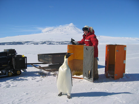
For her Ph.D. research, Jessica studied the diving physiology of marine mammals and birds. Her filed research took her all the way to Antarctica, where she focused on oxygen depletion in diving emperor penguins. Jessica is also an Antarctic diver!
Geese Trainer

Image Credit: UBC Media Relations
Jessica investigated the high‐flying bar-headed goose during her post‐doctoral research at the University of British Columbia. She trained geese to fly in a wind tunnel while obtaining various physiological measurements in reduced oxygen conditions.
Wilderness Survival Expert

In 2013, Jessica was selected as an Astronaut Candidate. While training to be a full-fledged astronaut, she participated in three days of wilderness survival training near Rangeley, Maine, which was the first phase of her intensive astronaut training program.
Mission Control Flight Controller
In our astronaut office, Jessica gained extensive mission control experience, including serving as the Lead Capsule Communicator (CapCom) for Expedition 47, the BEAM (Bigelow expandable module on the International Space Station) mission and an HTV (Japanese Space Agency cargo vehicle) mission. The CapCom is the flight controller that speaks directly to the astronaut crew in space, on behalf of the rest of the Mission Control team.
She’s reconnecting with her best friend... in space!

Following a successful launch to the space station, NASA astronaut Christina Koch tweeted this image of Jessica and the crew on their journey to the orbital lab in a Soyuz spacecraft. Excitement was high as Christina tweeted, “What it looks like from @Space_Station when your best friend achieves her lifelong dream to go to space. Caught the second stage in progress! We can’t wait to welcome you onboard, crew of Soyuz 61!”

We know. #FriendshipGoals.
Follow Jessica on Twitter at @Astro_Jessica and follow the International Space Station on Twitter, Instagram and Facebook to keep up with all the cool stuff happening on our orbital laboratory.
Make sure to follow us on Tumblr for your regular dose of space: http://nasa.tumblr.com
Forecasting D-Day From Above

Image Credit: Department of Transportation. U.S. Coast Guard. Office of Public and International Affairs
It was the raw courage of the more than 160,000 Allied troops who stormed an 80-kilometer (50-mile) stretch of heavily fortified beaches in Normandy, France, that made victory on D-Day possible. But without the sound advice of meteorologists and geologists working behind the scenes, one of the most consequential battles in human history could have gone quite differently.
As D-Day neared, the American meteorologists predicted fair weather on June 5 and pushed for invasion, based on a forecasting method that gave great weight to historical weather conditions for a given date and location. The British forecasters took a different approach, focusing instead on analyzing measurements of temperature, pressure, and humidity to try to map out weather fronts. Unlike the Americans, the British teams predicted low clouds and stormy weather on June 5. At the last minute, Captain James Martin Stagg, the highest ranking of the meteorologists, convinced Eisenhower to postpone the invasion.

NASA Earth Observatory images by Joshua Stevens, using Landsat data from the U.S. Geological Survey
Meanwhile, on the other side of the English Channel, German meteorologists had come to the same conclusion—and then some. Their forecasters had predicted that gale-force winds would arrive on June 5 and persist until mid-June. The Germans were so confident that the Allies would not dare attack that they allowed many soldiers to leave their posts on the beaches and take part in war games in Rennes, France. Field Marshal Erwin Rommel felt comfortable enough to return to Germany to deliver a pair of shoes to his wife as a birthday present.

Image Credit: Department of Defense. Department of the Army. Office of the Deputy Chief of Staff for Operations. U.S. Army Audiovisual Center. ca. 1974-5/15/1984
When the first paratroopers were dropped behind enemy lines around midnight and the first wave of Allied boats began to swarm the beaches at dawn on June 6, the weather was still far from ideal. Cloud cover meant many paratroopers ended up in the wrong locations, and rough seas and high winds made the task of landing boats and unloading tanks a terrible challenge. But by noon the skies cleared, just as the Allied meteorologists had predicted. The Germans, meanwhile, had been caught off guard. That day the Allies endured thousands of causalities, but they established a toehold in France that they would never give up.

NASA Earth Observatory images by Joshua Stevens, using Landsat data from the U.S. Geological Survey
An enormous amount of scientific expertise went into even the most unscientific of tasks, like rolling a tank up the Normandy beaches. Prior to the invasion, Allied military planners studied nearly one million aerial photographs of the shores of Normandy to find the best landing sites. The aerial photographs would have looked something like the Landsat 8 images shown above. Acquired by the Operational Land Imager (OLI) on July 15, 2018, these image offer a top-down view of the sandy Normandy beaches that were center stage on D-Day.
Read the full story: https://earthobservatory.nasa.gov/images/145143/forecasting-d-day
Make sure to follow us on Tumblr for your regular dose of space: http://nasa.tumblr.com.
How do you guys help with climate change?
When you first saw Earth from all the way up in space, what were your first thoughts? Did it change the way you viewed things?

Guy Bluford Changed the Course of Space History
On Aug. 30, 1983, Guion Bluford, better known as Guy, became the first African American to fly to space. An accomplished jet pilot and aerospace engineer, Bluford became part of NASA’s 1978 astronaut class that included the first African American, the first Asian American, and the first women astronauts.
He and the other crew members of mission STS-8 were aboard the orbiter Challenger as it lifted off from Kennedy Space Center in Florida; it was the first nighttime launch and landing of the Space Shuttle program. While aboard, he and the other crew members deployed the Indian National Satellite (INSAT-1B), operated a Canadian-built robot arm, conducted experiments with live cell samples, and participated in studies measuring the effects of spaceflight on humans.
Guy Bluford chased his childhood dream of becoming an aerospace engineer, and in doing so, changed history and encouraged other Black astronauts to follow in his footsteps.
Make sure to follow us on Tumblr for your regular dose of space—and for milestones like this!

We’re studying a new method of water recycling and carbon dioxide removal that relies on specific geometric shapes and fluid dynamics, rather than complex machinery, in an effort to help build better life support systems for spacecraft. The research could also teach us more about the water processing approaches we take on Earth. Here, NASA astronaut Jack Fischer, is working with the Capillary Structures for Exploration Life Support (Capillary Structures) investigation capillary sorbent hardware that is made up of 3D printed contractors that are supported by tubing, valves and a pump.
Learn more about how this highly interactive investigation works, and what we could learn from the results HERE.
Make sure to follow us on Tumblr for your regular dose of space: http://nasa.tumblr.com

Of course Saturn brought its ring light.
On June 25, 2023, our James Webb Space Telescope made its first near-infrared observations of Saturn. The planet itself appears extremely dark at this infrared wavelength, since methane gas absorbs almost all the sunlight falling on the atmosphere. The icy rings, however, stay relatively bright, leading to Saturn’s unusual appearance in this image.
This new image of Saturn clearly shows details within the planet’s ring system, several of the planet’s moons (Dione, Enceladus, and Tethys), and even Saturn’s atmosphere in surprising and unexpected detail.
These observations from Webb are just a hint at what this observatory will add to Saturn’s story in the coming years as the science team delves deep into the data to prepare peer-reviewed results.
Download the full-resolution image, both labeled and unlabeled, from the Space Telescope Science Institute.
Make sure to follow us on Tumblr for your regular dose of space!
Water on Mars!

Did you hear? New findings from our Mars Reconnaissance Orbiter (MRO) provide the strongest evidence yet that liquid water flows intermittently on present-day Mars.
Using an imaging spectrometer on MRO, we found hydrated minerals on slopes where mysterious streaks are seen on Mars. One thing that researchers noticed was that the darkish streaks appear to ebb and flow over time. During warm seasons, they darken and then fade in cooler seasons.

When discovered in 2010, these downhill flows known as recurring slope lineae (RSL) were thought to be related to liquid water. With the recent spectral detection of molecular water, we’re able to say it’s likely a shallow subsurface flow explains the darkening.
Mars is so cold, how could liquid water flow there? Great question! Since this liquid water is briny, the freezing point would be lower than that of pure water. Also, these saline slopes appear on Mars when temperatures are above minus 10 degrees Fahrenheit (minus 23 Celsius).
The dark, narrow streaks flowing downhill in the below image are roughly the length of a football field.

So there’s water, but how much? Currently we think this area has a very small amount of water, probably just enough to wet the top layer of the surface of Mars. The streaks are around four to five meters wide and 200 to 300 meters long.
Could humans drink this water? The salts in the water appear to be perchlorates, so you probably wouldn’t want to drink the water. It would most likely be very salty and would need to be purified before human consumption.
Perchlorate...What is that? A perchlorate is a salt that absorbs water from the air. Learn more about how it’s helping us unlock the mysteries of Mars in this video:
What’s next? We want to look for more locations where brine flows may occur. We have only covered 3% of Mars at resolutions high enough to see these features.
For more information on the Mars announcement, visit our Journey to Mars landing page. There is also a full recap of the press conference HERE, and a short recap below.
Make sure to follow us on Tumblr for your regular dose of space: http://nasa.tumblr.com
-
 john-erby liked this · 3 years ago
 -
 2reputationpegacorns liked this · 3 years ago
 -
 bethelnie-blog liked this · 5 years ago
 -
 jackthbear liked this · 5 years ago
 -
 lucmarcou liked this · 5 years ago
 -
 insertanonymousname liked this · 5 years ago
 -
 thatblondenikkki liked this · 5 years ago
 -
chikasmania liked this · 6 years ago
-
 alwaysmej reblogged this · 6 years ago
 -
 mamma-mercy reblogged this · 6 years ago
 -
 gentianablue reblogged this · 6 years ago
 -
gentianablue liked this · 6 years ago
-
 ellisper liked this · 6 years ago
 -
 teaching-science reblogged this · 6 years ago
 -
 alivehouse liked this · 6 years ago
 -
 justanoldfashiontumblog liked this · 6 years ago
 -
 twinamoto liked this · 6 years ago
 -
 starscapades reblogged this · 6 years ago
 -
starscapades liked this · 6 years ago
-
 terrylhills liked this · 6 years ago
 -
 the-telescope-times liked this · 6 years ago
 -
the-telescope-times reblogged this · 6 years ago
-
 patrochillesunflower liked this · 6 years ago
 -
 galaxystew liked this · 6 years ago
 -
 apuhasnowowl liked this · 6 years ago
 -
 princesschloesworld liked this · 6 years ago
 -
 randomsquirrel liked this · 6 years ago
 -
heimdall555 liked this · 6 years ago
-
 monkey-odysseus77 liked this · 6 years ago
 -
 koalablu liked this · 6 years ago
 -
 goldnwlf liked this · 6 years ago
 -
 oshinytomato liked this · 6 years ago
 -
 biblicaaly-accurate-angel-main liked this · 6 years ago
 -
 annethecaptain liked this · 6 years ago
 -
 hell-bomb liked this · 6 years ago
 -
 krshush liked this · 6 years ago
 -
 bella-ballerinaa liked this · 6 years ago
 -
 aana-gram liked this · 6 years ago
 -
 foxochan liked this · 6 years ago
 -
 incognito-insomniac reblogged this · 6 years ago
 -
 un-ionizetheradlab reblogged this · 6 years ago
Explore the universe and discover our home planet with the official NASA Tumblr account
1K posts