Why Does It Take So Long For The Rover To Reach Mars?
Why does it take so long for the rover to reach Mars?
More Posts from Nasa and Others
You’ve seen things floating in space, but why does that happen and how does it affect science being conducted aboard the International Space Station?
Sure, floating looks like fun, but it could also unlock new scientific discoveries!
Microgravity makes the International Space Station the perfect place to perform research that is changing the lives of people on Earth, and preparing us to go deeper into space. This season on our series NASA Explorers, we are following science into low-Earth orbit and seeing what it takes to do research aboard the space station.
Follow NASA Explorers on Facebook to catch new episodes of season 4 every Wednesday. https://www.facebook.com/NASAExplorersSeries/
Solar System: Things to Know This Week
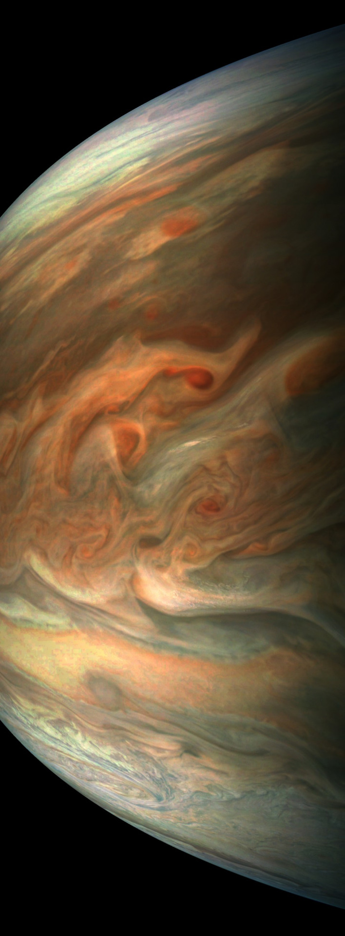
Our Juno mission has been exploring Jupiter since July 2016 with a special passenger on board: JunoCam, an instrument designed to take spectacular close-up color images of the largest planet in our solar system. From the raw images, citizen scientists have processed a range of beautiful photographs that highlight Jupiter's features, even turning them into works of art. Below, 10 stunning images JunoCam has given us over the past year.
1. Jovian tempest.

This color-enhanced image of a massive, raging storm in Jupiter's northern hemisphere was captured by our Juno spacecraft during its ninth close flyby on Oct. 24, 2017. The storm is rotating counter-clockwise with a wide range of cloud altitudes, and the darker clouds are expected to be deeper in the atmosphere than the brightest clouds.
2. A southern stunner.

Jupiter's southern hemisphere shows off in beautiful detail in this image taken on Oct. 24, 2017. The color-enhanced view captures one of the white ovals in the "String of Pearls," one of eight massive rotating storms at 40 degrees south latitude on the gas giant planet.
3. Dreaming in color.

Artist Mik Petter created this unique digital piece using data from the JunoCam. The art form, known as fractals, uses mathematical formulas to create an infinite variety of form, detail, color and light. The original JunoCam image was taken on July 10, 2017.
4. Jovian moon shadow.

Jupiter's moon Amalthea casts a shadow on the gas giant planet in this image taken on Sept. 1, 2017. The elongated shape of the shadow is a result of both the location of the moon with relation to Jupiter in this image as well as the irregular shape of the moon itself.
5. 95 minutes over Jupiter.

Once every 53 days, Juno swings close to Jupiter, speeding over its clouds. In about two hours, the spacecraft travels from a perch over Jupiter's north pole through its closest approach (perijove), then passes over the south pole on its way back out. This sequence shows 11 color-enhanced images from Perijove 8 (Sept. 1, 2017) with the south pole on the left (11th image in the sequence) and the north pole on the right (first image in the sequence).
6. Soaring high.
This striking image of Jupiter was taken on Sept. 1, 2017 as Juno performed its eighth flyby. The spacecraft was 4,707 miles (7,576 kilometers) from the tops of the clouds of the planet at a latitude of about -17.4 degrees. Noteworthy: "Whale's Tail" and "Dan's Spot."
7. In true color.
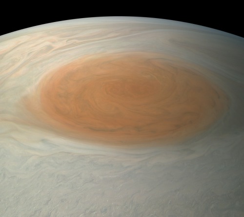
This true-color image offers a natural color rendition of what the Great Red Spot and surrounding areas would look like to human eyes from Juno's position. The image was taken on July 10, 2017 as the Juno spacecraft performed its seventh close flyby of Jupiter.
8. The 'face' of Jupiter.

JunoCam images aren't just for art and science—sometimes they're created for a good chuckle. This image, processed by citizen scientist Jason Major, is titled "Jovey McJupiterface." By rotating the image 180 degrees and orienting it from south up, two white oval storms turn into eyeballs, and the "face" of Jupiter is revealed. The original image was taken by the Juno spacecraft on May 19, 2017.
9. Bands of clouds.

This enhanced-color image of Jupiter's bands of light and dark clouds was created by citizen scientists Gerald Eichstädt and Seán Doran. Three of the white oval storms known as the "String of Pearls" are visible near the top of the image. Each of the alternating light and dark atmospheric bands in this image is wider than Earth, and each rages around Jupiter at hundreds of miles (kilometers) per hour. The lighter areas are regions where gas is rising, and the darker bands are regions where gas is sinking. Juno captured the image on May 19, 2017.
10. The edge.

This enhanced-color image of a mysterious dark spot on Jupiter seems to reveal a Jovian "galaxy" of swirling storms. Juno captured this image on Feb. 2, 2017 and citizen scientist Roman Tkachenko enhanced the color to bring out the rich detail in the storm and surrounding clouds. Just south of the dark storm is a bright, oval-shaped storm with high, bright, white clouds, reminiscent of a swirling galaxy. As a final touch, he rotated the image 90 degrees, turning the picture into a work of art.
To learn more about the Juno mission at Jupiter, visit: www.nasa.gov/juno.
Follow the Juno mission on Facebook, Instagram and Twitter.
Make sure to follow us on Tumblr for your regular dose of space: http://nasa.tumblr.com.
Why We Study the Sun-Earth Connection – Explained Through Songs
We're launching a new mission to the International Space Station to continue measurements of the Sun's energy reaching Earth.

The Total and Spectral solar Irradiance Sensor (TSIS-1) will precisely measure the total amount of sunlight that falls on Earth and how that light is distributed among different wavelengths, including the ultraviolet, visible and infrared. This will give us a better understanding of Earth’s primary energy supply and help improve models simulating Earth’s climate.
1. You are my sunshine, my only sunshine. You make me happy when skies are gray.

The Sun is Earth's sunshine and it does more than make us happy; it gives us life. Our Sun's energy drives our planet's ocean currents, seasons, weather and climate. Changes in the Sun also alter our climate in at least two ways.
First, solar radiation has a direct effect where it heats regions of Earth, like our oceans, land, and atmosphere. Second, the solar radiation can cause indirect effects, such as when sunlight interacts with molecules in the upper atmosphere to produce ozone which can affect human health.

Earth’s energy system is in a constant dance to maintain a balance between incoming energy from the Sun and outgoing energy from Earth to space, which scientists call Earth’s energy budget. If you have more energy absorbed by the Earth than leaving it, its temperature increases and vice versa. Because the Sun is Earth's fundamental energy source and only sunshine, we need a quantitative record of the Sun's solar energy output. TSIS-1 will provide the most accurate measurements ever made of sunlight as seen from above Earth’s atmosphere.
2. You're hot then you're cold…You're in then you're out. You're up then you're down.

The energy flow between the Earth and Sun's connection is not a constant thing. The Sun can be fickle, sometimes it puts out slightly more energy and some years less. Earth is no better. The Earth absorbs different amounts of the Sun's energy depending on many factors, such as the presence of clouds and tiny particles in the atmosphere called aerosols.
What we do know is that the Sun's cycle is about 11 years rolling through periods of quiet to times of intense activity. When the Sun is super-intense it releases explosions of light and solar material. This time is a solar maximum.
When the Sun is in a quiet state this period is called the solar minimum.

Over the course of one solar cycle (one 11-year period), the Sun’s total emitted energy varies on average at about 0.1 percent. That may not sound like a lot, but the Sun emits a large amount of energy – 1,361 watts per square meter. Even fluctuations at just a tenth of a percent can affect Earth. That's why TSIS-1 is launching: to help scientists understand and anticipate how changes in the Sun will affect us on Earth.
3. You're so vain. You probably think this climate model is about you.

Scientists use computer models to interpret changes in the Sun’s energy input. If less solar energy is available, scientists can gauge how that affects Earth’s atmosphere, oceans, weather and seasons by using computer simulations. But the Sun is just one of many factors scientists use to model Earth’s climate. A lot of other factors come into play in addition to the energy from the Sun. Factors like greenhouse gases, clouds scattering light and small particles in the atmosphere called aerosols all can affect Earth’s climate so they all need to be included in climate models. So, while we need to measure the total amount of energy from the Sun, we also need to understand how these other factors alter the amount of energy reaching Earth's surface and affect our climate.
4. Someday we'll find it, the rainbow connection. The lovers, the dreamers and me.

We receive the Sun's energy in many different wavelengths, including visible light (rainbows!) as well as light we can't see like infrared and ultraviolet wavelengths. Each color or wavelength of light from the Sun affects Earth’s atmosphere differently.
For instance, ultraviolet light from the Sun can affect Earth's ozone. High in the atmosphere is a layer of protective ozone gas. Ozone is Earth’s natural sunscreen, absorbing the Sun’s most harmful ultraviolet radiation and protecting living things below. But ozone is vulnerable to certain gases made by humans that reach the upper atmosphere. Once there, they react in the presence of sunlight to destroy ozone molecules. Currently, several satellites from us and the National Oceanic and Atmospheric Administration (NOAA) track the ozone in the upper atmosphere and the solar energy that drives the photochemistry that creates and destroys ozone. Our new instrument, TSIS-1, will join that fleet with even better accuracy.

TSIS-1 will see different types of ultraviolet (UV) light, including UV-B and UV-C. Each plays a different role in the ozone layer. UV-C rays are essential in creating ozone. UV-B rays and some naturally occurring chemicals regulate the abundance of ozone in the upper atmosphere. The amount of ozone is a balance between these natural production and loss processes.
TSIS-1 data of the Sun's UV energy will help improve computer models of the atmosphere that need accurate measurements of sunlight across the ultraviolet spectrum to model the ozone layer correctly. While UV light represents a tiny fraction of the total sunlight that reaches the top of Earth's atmosphere, it fluctuates from 3 to 10 percent, a change that, in turn causes small changes in the chemical composition and thermal structure of the upper atmosphere.
This is just one of the important applications of TSIS-1 measurements. TSIS-1 will measure how the Sun's energy is distributed over 1,000 different wavelengths.
5. Every move you make…every step you take, I'll be watching you.

TSIS-1 will continue our nearly 40 years of closely studying the total amount of energy the Sun sends to Earth from space. We've previously studied this 'total solar irradiance' with nine previous satellites, currently with Solar Radiation and Climate Experiment, (SORCE).

NASA’s SORCE collected this data on the total amount of the Sun’s radiant energy throughout Sept. 2017. The satellite actually detected a dip in total irradiance – or the total amount of energy from the Sun- during the month’s intense solar activity.
But there's still very much we don't know about total solar irradiance. We do not know how it varies over longer timescales. Longer term observations are especially important because scientists have observed unusually quiet magnetic activity from the Sun for the past two decades with previous satellites. During the last prolonged solar minimum in 2008-2009, our Sun was the quietest it has ever been since we started observations in 1978. Scientists expect the Sun to enter a solar minimum within the next three years, and TSIS-1 will be primed to take measurements of the next minimum and see if this is part of a larger trend.
For all the latest Earth updates, follow us on Twitter @NASAEarth or Facebook.
Make sure to follow us on Tumblr for your regular dose of space: http://nasa.tumblr.com.

Zoom to the Moon! Astronauts will blast off to the Moon in the Orion spacecraft with NASA’s Space Launch System, the world’s most powerful rocket ever built. Help #AstronautSnoopy launch into deep space, farther than any human or bird has ever gone before. https://www.nasa.gov/feature/peanuts-toys-and-books-commemorate-50th-anniversary-of-apollo/
Celebrate #BlackHoleFriday with Nurturing Baby Stars

Are you throwing all your money into a black hole today?
Forget Black Friday — celebrate #BlackHoleFriday with us and get sucked into this recent discovery of a black hole that may have sparked star births across multiple galaxies.
If confirmed, this discovery would represent the widest reach ever seen for a black hole acting as a stellar kick-starter — enhancing star formation more than one million light-years away. (One light year is equal to 6 trillion miles.)
A black hole is an extremely dense object from which no light can escape. The black hole's immense gravity pulls in surrounding gas and dust. Sometimes, black holes hinder star birth. Sometimes — like perhaps in this case — they increase star birth.
Telescopes like our Chandra X-ray Observatory help us detect the X-rays produced by hot gas swirling around the black hole. Have more questions about black holes? Click here to learn more.
Make sure to follow us on Tumblr for your regular dose of space: http://nasa.tumblr.com.
We’re honored that New Horizon’s image of Pluto was recognized as one of 2015’s top 10 photos by @timemagazine.
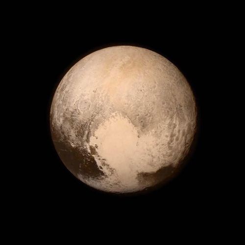
TIME’s Top 10 Photos of 2015. ⠀⠀⠀⠀⠀⠀⠀⠀⠀ Each photograph, carefully culled from thousands and presented here unranked, reflects a unique and powerful point of view that represents the best of photojournalism this year. ⠀⠀⠀⠀⠀⠀⠀⠀⠀ 2015 gave us the ever picture of Pluto, made by @NASA’s New Horizons spacecraft. The high-resolution color image was taken more than nine years after the two cameras that shot it left Earth in the fastest spacecraft ever launched into space. “This is really the completion of a 50-year quest to explore all of the planets in our solar system,” says photographer Alan Stern (@alanstern). “NASA began under President Kennedy and finished under President Obama. I believe that 100 years from now, this image will be an icon from the year 2015.” ⠀⠀⠀⠀⠀⠀⠀⠀⠀ Read more from each #photographer at time.lightbox.com. ⠀⠀⠀⠀⠀⠀⠀⠀⠀ #topten #bestof2015 #pluto #space http://ift.tt/1O7fKGW
Solar System 10 Things: Looking Back at Pluto
In July 2015, we saw Pluto up close for the first time and—after three years of intense study—the surprises keep coming. “It’s clear,” says Jeffery Moore, New Horizons’ geology team lead, “Pluto is one of the most amazing and complex objects in our solar system.”
1. An Improving View

These are combined observations of Pluto over the course of several decades. The first frame is a digital zoom-in on Pluto as it appeared upon its discovery by Clyde Tombaugh in 1930. More frames show of Pluto as seen by the Hubble Space Telescope. The final sequence zooms in to a close-up frame of Pluto taken by our New Horizons spacecraft on July 14, 2015.
2. The Heart

Pluto’s surface sports a remarkable range of subtle colors are enhanced in this view to a rainbow of pale blues, yellows, oranges, and deep reds. Many landforms have their own distinct colors, telling a complex geological and climatological story that scientists have only just begun to decode. The image resolves details and colors on scales as small as 0.8 miles (1.3 kilometers). Zoom in on the full resolution image on a larger screen to fully appreciate the complexity of Pluto’s surface features.
3. The Smiles

July 14, 2015: New Horizons team members Cristina Dalle Ore, Alissa Earle and Rick Binzel react to seeing the spacecraft's last and sharpest image of Pluto before closest approach.
4. Majestic Mountains

Just 15 minutes after its closest approach to Pluto, the New Horizons spacecraft captured this near-sunset view of the rugged, icy mountains and flat ice plains extending to Pluto's horizon. The backlighting highlights more than a dozen layers of haze in Pluto's tenuous atmosphere. The image was taken from a distance of 11,000 miles (18,000 kilometers) to Pluto; the scene is 780 miles (1,250 kilometers) wide.
5. Icy Dunes

Found near the mountains that encircle Pluto’s Sputnik Planitia plain, newly discovered ridges appear to have formed out of particles of methane ice as small as grains of sand, arranged into dunes by wind from the nearby mountains.
6. Glacial Plains

The vast nitrogen ice plains of Pluto’s Sputnik Planitia – the western half of Pluto’s “heart”—continue to give up secrets. Scientists processed images of Sputnik Planitia to bring out intricate, never-before-seen patterns in the surface textures of these glacial plains.
7. Colorful and Violent Charon

High resolution images of Pluto’s largest moon, Charon, show a surprisingly complex and violent history. Scientists expected Charon to be a monotonous, crater-battered world; instead, they found a landscape covered with mountains, canyons, landslides, surface-color variations and more.
8. Ice Volcanoes

One of two potential cryovolcanoes spotted on the surface of Pluto by the New Horizons spacecraft. This feature, known as Wright Mons, was informally named by the New Horizons team in honor of the Wright brothers. At about 90 miles (150 kilometers) across and 2.5 miles (4 kilometers) high, this feature is enormous. If it is in fact an ice volcano, as suspected, it would be the largest such feature discovered in the outer solar system.
9. Blue Rays

Pluto's receding crescent as seen by New Horizons at a distance of 120,000 miles (200,000 kilometers). Scientists believe the spectacular blue haze is a photochemical smog resulting from the action of sunlight on methane and other molecules in Pluto's atmosphere. These hydrocarbons accumulate into small haze particles, which scatter blue sunlight—the same process that can make haze appear bluish on Earth.
10. Encore

On Jan. 1, 2019, New Horizons will fly past a small Kuiper Belt Object named MU69 (nicknamed Ultima Thule)—a billion miles (1.5 billion kilometers) beyond Pluto and more than four billion miles (6.5 billion kilometers) from Earth. It will be the most distant encounter of an object in history—so far—and the second time New Horizons has revealed never-before-seen landscapes.
Make sure to follow us on Tumblr for your regular dose of space: http://nasa.tumblr.com.
Go Behind the Scenes of Science in Space

Gravity rules everything on Earth, from how our bodies develop to what our research can reveal, but what happens when we go 250 miles up to the International Space Station?

Get ready to go behind the scenes of what it takes to get science to space, and meet the people who make it happen.

Introducing Season 4 of NASA Explorers: Microgravity. Floating isn’t just fun. Microgravity could open the door to discovery.
You’ve seen things floating in space, but why does that happen and how does it affect science being conducted aboard the International Space Station?
Microgravity makes the International Space Station the perfect place to perform research that is changing the lives of people on Earth, and preparing us to go deeper into space. This season on our series NASA Explorers, we are following science into low-Earth orbit and seeing what it takes to do research aboard the space station.
Follow NASA Explorers on Facebook to catch new episodes of season 4 every Wednesday!
Are the rumors about the ozone layer being totally fixed true ? If yes , is it susceptible of being opened again ans if no, is it suspecte
Comin’ in Hot: Seven Things to Know About our New Heat Shield
What goes up, must come down, and from space, without burning up in an atmosphere. That’s why we’re pumped for the Low-Earth Orbit Flight Test of an Inflatable Decelerator, or LOFTID. Launching on Nov. 1, 2022, with the National Oceanic and Atmospheric Administration’s (NOAA) Joint Polar Orbiting Satellite System-2 (JPSS-2) mission, this technology demonstration marks the next step in advancing an innovative heat shield design that could one day be used to land heavy payloads – including humans – on Mars!

Here are seven things to know about this innovative re-entry system:
1. LOFTID is the first-ever in-orbit test of this technology.
Inflatable heat shields, called Hypersonic Inflatable Aerodynamic Decelerators (HIADs), have been in the works for more than a decade. In 2012, the third of the Inflatable Re-entry Vehicle Experiments (IRVE) launched on a suborbital sounding rocket from the Wallops Flight Facility, demonstrating a 3-meter (10-foot) diameter inflatable heat shield.

But the LOFTID re-entry vehicle, at 19.7 feet (6 meters) in diameter, will be the largest blunt body aeroshell to ever go through atmospheric entry. Designed to withstand temperatures as high as 2900°F (1600°C), this first-ever in-orbit test of this technology will prove if it can successfully slow down large payloads – such as crewed spacecraft, robotic explorers, and rocket components – enabling them to survive the heat of re-entry at planetary destinations with an atmosphere.
2. You can find out how this tech works in real-time.
LOFTID is unique in that all operations will happen within a few hours of launch. After the JPSS-2 satellite safely reaches orbit, the LOFTID vehicle will separate from the upper stage of the Atlas V rocket and begin re-entry into Earth’s atmosphere. If all goes as planned, the technology will help the vehicle decelerate from hypersonic (more than 25 times faster than the speed of sound) down to subsonic flight, less than 609 miles per hour for a safe splash down and recovery from the Pacific Ocean.
While in flight, engineers at NASA’s Langley Research Center will receive location data every 20 seconds and onboard sensors and cameras will record more comprehensive data about the technology’s performance. You can get a behind-the-scenes look at Langley’s Flight Mission Support Center where the LOFTID project team will be monitoring the flight test at NASA.gov/live following the launch.

3. A lemon-sized capsule ejected into the Pacific Ocean will hold key flight data.
The LOFTID re-entry vehicle will record both sensor and camera data during its flight. The data will include the temperatures and pressures experienced by the heat shield and will illustrate how well the technology performed during the demonstration.
Although the goal is to retrieve the LOFTID re-entry vehicle after it splashes down in the Pacific Ocean, the team wanted a back-up option just in case they can’t recover it. Enter the tiny yellow package called an ejectable data module (EDM) which will also record flight data. The EDM will be released from the spacecraft at an altitude of about 50,000 feet. It will free fall into the Pacific Ocean off the coast of Hawaii and should land within 10 miles of the spacecraft’s splash down location. A recovery team, that has practiced hide-and-seek of the EDM on land and sea, will use GPS to search an approximately 900-mile area of the Pacific Ocean to find their “lemon.”

4. This heat shield packs a punch.
Although NASA has historically relied on rigid aeroshells, parachutes, and retro-propulsion (rockets) to decelerate people, vehicles, and hardware during entry, descent, and landing operations, a benefit of inflatable heat shields is that they take up less space in a rocket, allowing more room for other hardware or payloads. LOFTID’s aeroshell has been folded and tightly packed down to 4 by 1.5 feet for launch and stacked in the United Launch Alliance (ULA) Atlas V rocket payload fairing.

5. LOFTID is dedicated in honor of one of its innovators.
LOFTID was developed as a partnership with ULA and is dedicated to the memory of Bernard Kutter, ULA manager of advanced programs, who passed away in August 2020. Kutter was instrumental in advancing the inflatable heat shield design and developing the plan to test the system on an Atlas V rocket. He was an advocate for both space technology and expanding access to space. Kutter’s NASA and ULA counterparts agree that LOFTID is unlikely to have made it to space without his vision and passion.
6. LOFTID is made of tough stuff.
Synthetic fibers make up the inflatable structure, braided into tubes that are, by weight, 10 times stronger than steel. The tubes are coiled so that they form the shape of a blunt cone when inflated. The thermal protection system that covers the inflatable structure can survive searing entry temperatures up to 2,900 degrees Fahrenheit. Researchers used the same heat-shielding materials to create a fire shelter prototype for firefighters battling forest fires.
7. You can make your own LOFTID Halloween costume!
Still looking for an out-of-this world Halloween costume? With a few commonly found materials, like orange pool noodles and duct tape, you can create your own LOFTID costume. However, we make no promises of protecting or slowing you down from becoming the life of the party.

Follow @NASA_Technology for the latest updates on LOFTID. Don’t miss our live coverage leading up to launch from the Vandenberg Space Force Base in California. The NASA Edge JPSS-2 Tower Rollback Show airs live on NASA TV and YouTube on Tuesday, Nov. 1 at 12 a.m. EDT, and NASA TV live launch coverage will begin at 4:45 a.m. EDT.
Make sure to follow us on Tumblr for your regular dose of space!
-
 watch reblogged this · 1 year ago
 -
 mygoopfestivalpasta liked this · 4 years ago
 -
 solmarron18 liked this · 4 years ago
 -
 plantmonk liked this · 4 years ago
 -
 metaldinleyenametal liked this · 4 years ago
 -
 twentytwofour liked this · 4 years ago
 -
 shailendra65631 liked this · 4 years ago
 -
 narcicious reblogged this · 4 years ago
 -
narcicious liked this · 4 years ago
-
 unofficially-nasa reblogged this · 4 years ago
 -
 dragons-barb liked this · 4 years ago
 -
 danny1234 liked this · 4 years ago
 -
 buffystolethetardis liked this · 4 years ago
 -
 juniper-edelweiss liked this · 4 years ago
 -
 capricious-meraki reblogged this · 4 years ago
 -
 joostacheinthemaking liked this · 4 years ago
 -
 fool-of-a-tooook liked this · 4 years ago
 -
 glitterymusclecarantiquecar-blog liked this · 4 years ago
 -
delightfulpaperpost liked this · 4 years ago
-
 hewhohasnil liked this · 4 years ago
 -
 spacenerd84 liked this · 4 years ago
 -
 englishpancakes liked this · 4 years ago
 -
 doogamus liked this · 4 years ago
 -
 yuiko2627 liked this · 4 years ago
 -
 ashjackson69-blog reblogged this · 4 years ago
 -
 hizrah liked this · 4 years ago
 -
delicatemusictale liked this · 4 years ago
-
 aero-cosmo-blog liked this · 4 years ago
 -
 hassan-1968 liked this · 4 years ago
 -
 chocolateforyou liked this · 4 years ago
 -
 arius-starwalker-1412 reblogged this · 4 years ago
 -
arius-starwalker-1412 liked this · 4 years ago
-
 i-don-world liked this · 4 years ago
 -
 emalysse liked this · 4 years ago
 -
 arizona819 liked this · 4 years ago
 -
 rosaliachristian liked this · 4 years ago
 -
 lethargicrecluse-blog liked this · 4 years ago
 -
 sunfogo liked this · 4 years ago
 -
sbi6elr liked this · 4 years ago
-
 a-secluded-garden liked this · 4 years ago
 -
 lovely-blue-galaxy reblogged this · 4 years ago
Explore the universe and discover our home planet with the official NASA Tumblr account
1K posts