6 Ways Earth Observations Tackle Real-World Problems
6 Ways Earth Observations Tackle Real-World Problems
This summer, 30 research projects were launched by recent college graduates and early career professionals as part of our DEVELOP program. The aim is to use our satellite observations of Earth to address an environmental or public policy issue. And they have just 10 weeks to do it! On Aug. 10, 2016, the “DEVELOPers” gathered at our Headquarters in Washington, DC to showcase their results. So, how can Earth observations solve real-world problems? Let’s take a look:

1. They help land managers identify the locations of invasive species.
Austin Haney, DEVELOP project co-lead at University of Georgia, has seen first-hand how an invasive species can affect the ecosystem of Lake Thurmond, a large reservoir that straddles the border between Georgia and South Carolina. Birds in the area “behave visibly different,” he said, after they consume a toxic cyanobacteria that lives on Hydrilla verticillata, an invasive aquatic plant. Ingesting the toxin causes a neurodegenerative disease and ultimately death. Scores of birds have been found dead near lake areas where large amounts of the toxin-supporting Hydrilla grow. To help lake managers better address the situation, Haney and project members developed a tool that uses data from the Landsat 8 satellite to map the distribution of Hydrilla across the lake.
Image Credit: NASA/Bill Ingalls

2. They help identify wildlife habitat threatened by wildfires.
Maps that depict habitat and fire risk in eastern Idaho previously stopped short of Craters of the Moon National Monument and Preserve, where shrubs and grasses transition to a sea of ankle-twisting basalt. But the environment is not as inhospitable as it first appears. Throughout the monument there are more than 500 kipukas —pockets of older lava capable of supporting some vegetation. That means it is also prone to burning. Project lead Courtney Ohr explained how her team used data from the Landsat 8 and Sentinel-2 satellites to develop a model that can simulate the area’s susceptibility to wildfires. Decision makers can use this model to monitor the remote wildlife habitat from afar.
Image Credit: NASA/Bill Ingalls

3. In conjunction with Instagram, they help find seaweed blooms
Who knew that Instagram could be a tool for science? One DEVELOP team searched for photographs of massive seaweed (sargassum) blooms in the Caribbean, mapped the locations, and then checked what satellites could see. In the process, they tested two techniques for finding algae and floating vegetation in the ocean.
Image Credit: Caribbean Oceans Team

4. They help conserve water by reducing urban stormwater runoff.
Atlanta’s sewer system is among the nation’s most expensive. Yet, the city still struggles with stormwater. It’s an uphill climb as new construction paves over more of the city, hindering its ability to absorb rain. The University of Georgia DEVELOP team partnered with The Nature Conservancy to address the problem.
Using satellite imagery, the team was able to pinpoint areas well-poised to capture more of the city’s runoff. They identified 17 communities ripe for expanding green infrastructure and reforestation. The team used the Land-Use Conflict Identification Strategy and Soil and Water Assessment Tool models and Landsat and Terra satellite data. Their analysis provides local groups with a working picture of the city’s water resources.
Image Credit: NASA/Bill Ingalls

5. They show the spread of the mite eating away Puerto Rico’s palm trees.
The red palm mite has devastated Puerto Rico’s trees in recent years. The insect chewed its way through coconut palms, bananas, and plantains on the island in the recent decade. Its spread has hurt crops across the Caribbean.
A DEVELOP team led by Sara Lubkin analyzed satellite imagery to track the mites’ rapid spread from 2002. The team mapped changes to vegetation, such as yellowing, and differences in canopy structure. They made use of imagery from Landsat, Hyperion, IKONOS, and aerial views. Their work can be used to mitigate current mite infestations and monitor and prevent future ones.
Image Credit: NASA/Bill Ingalls

6. They evaluate landslide-prone areas in the developing world
One team of DEVELOPers took on several projects to aid people in developing nations. This team from Alabama examined satellite imagery to find past landslides in the African nation of Malawi. Factors such as flooding after long periods of drought have made the country increasingly prone to landslides. Blending maps of the landscape, rainfall data, and population centers, the young researchers assessed the areas most at risk—and most in need of education and support—from landslides.
Image Credit: East Africa Disasters II Team
Want to read more about DEVELOP projects, or get involved? Summaries, images, and maps of current and past projects can be viewed HERE. You can also learn how to apply for the DEVELOP program HERE.
Make sure to follow us on Tumblr for your regular dose of space: http://nasa.tumblr.com
More Posts from Samstein1012 and Others
'NASA's Hubble Telescope Detects ‘Sunscreen' Layer on Distant Planet': via #NASA_APP
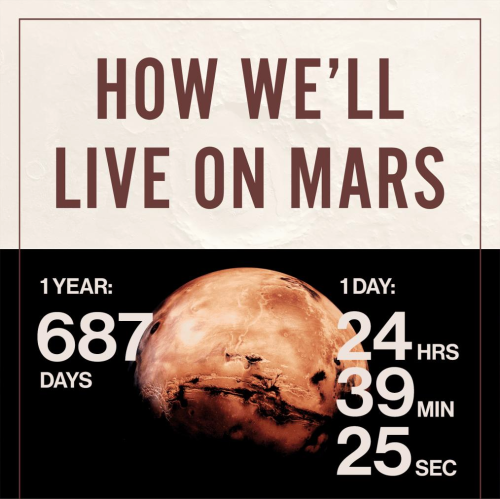
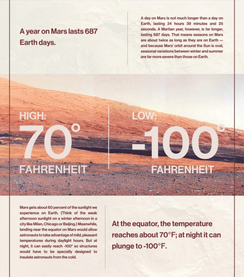
InSight Mission to Mars

Our InSight mission will place a fixed science outpost on Mars to study its deep interior. Findings and research from this project will address one of the most fundamental questions we have about planetary and solar system science – How in the world did these rocky planets form?
By investigating the interior structure and processes of Mars, the InSight mission will gain a better understanding of the evolutionary formation of planets, including Earth.
InSight will record Mars’ vital signs to learn more about the planet, including:

Seismic Activity:
A seismometer will be used to record the seismic activity on Mars. This will give us information on the crust, mantel and core; and the relationship between them.

Temperature:
A heat flow probe will be used to take Mars’ temperature and determine the change over the course of a full Martian year.

Reflexes:
By looking at how the rotation of Mars wobbles, we will better understand what the core size may be and its composition.

Launch for the InSight mission is scheduled for March 2016, and even though you can’t physically travel with the lander, you can send your name to the Red Planet onboard. Make sure to submit your name before Sept. 8!
Make sure to follow us on Tumblr for your regular dose of space: http://nasa.tumblr.com
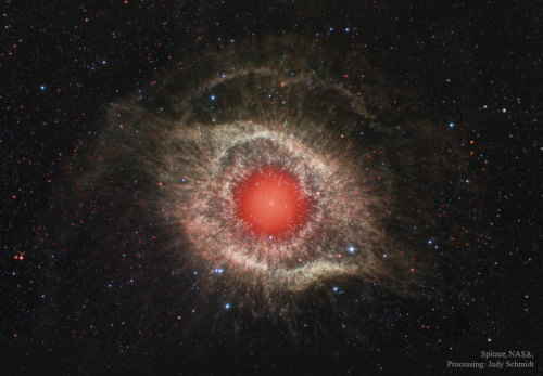
Helix Nebula // NGC 7293

Testing of the SLS Main Booster.


For more on the Fermi Paradox and why alien life hasn’t found us yet. (Infographic via futurism)
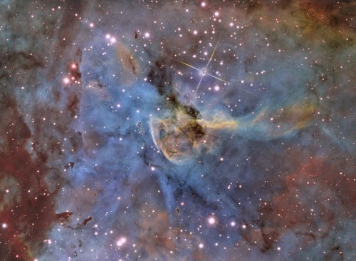
Life on Mars

Pluto in Combined Color
What is fascinating about Pluto is how young its surface is. We can see some canyons, planes, and mountains in this image - which is an indication of a young surface. This image of Pluto was taken when the New Horizons spacecraft was only 280,000 miles away from the surface. In the image you can see features as small as 1.4 miles! Four images from New Horizons’ Long Range Reconnaissance Imager (LORRI) were combined with color data from the Ralph instrument to create this enhanced color global view.
Credit: John’s Hopkin’s APL/NASA JPL
-
 thisisacatperson liked this · 4 years ago
 -
 thnks-fr-th-samulet liked this · 5 years ago
 -
 asiaphotoreview liked this · 7 years ago
 -
 enflightdesign liked this · 7 years ago
 -
 best-hotels-posts reblogged this · 8 years ago
 -
mule1971 liked this · 8 years ago
-
 thingsmydadmightlike-blog reblogged this · 8 years ago
 -
 carlosemiliopir liked this · 8 years ago
 -
 alicerobertstext reblogged this · 8 years ago
 -
 wanderingsigma reblogged this · 8 years ago
 -
 playingjax reblogged this · 8 years ago
 -
 vampirecherrie reblogged this · 8 years ago
 -
 susaniam liked this · 8 years ago
 -
 jumblejo reblogged this · 8 years ago
 -
 phoenixbluemusic liked this · 8 years ago
 -
 diabaliful reblogged this · 8 years ago
 -
 ascarosepion reblogged this · 8 years ago
 -
 neutrinotempest liked this · 8 years ago
 -
 poro-oletettu reblogged this · 8 years ago
 -
 tombcutie reblogged this · 8 years ago
 -
 mahinthjoe reblogged this · 8 years ago
 -
 artisanscribbles reblogged this · 8 years ago
 -
 mossdunce liked this · 8 years ago
 -
 aquitainequeen reblogged this · 8 years ago
 -
 mercy-angel-09 reblogged this · 8 years ago
 -
 vi2thesky reblogged this · 8 years ago
 -
 1stepforward2stepsbackcarousel reblogged this · 8 years ago
 -
 sixthrangerknight reblogged this · 8 years ago
 -
 rollingfisheyes reblogged this · 8 years ago
 -
 schpeelah reblogged this · 8 years ago
 -
 wretchedmeat reblogged this · 8 years ago
 -
 lyanna88-blog1 liked this · 8 years ago
 -
 thegamejustgotmorefierce reblogged this · 8 years ago
 -
 rlcampos reblogged this · 8 years ago
 -
whathappensisalwayshidden liked this · 8 years ago
-
 eskiworks liked this · 8 years ago
 -
wretchedmeat liked this · 8 years ago
-
 new-great-age-of-discovery reblogged this · 8 years ago
 -
 saltheartgal liked this · 8 years ago
 -
 justgo45-blog liked this · 8 years ago
 -
 omgpickaname reblogged this · 8 years ago
 -
omgpickaname liked this · 8 years ago
Elon Musk,Electric Cars,MIT, Spacex, NASA, Tesla and Taylor Alison Swift
34 posts