What’s Up For April 2016?
What’s Up for April 2016?
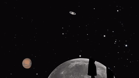
Jupiter, Mars, the Lyrid meteor shower and 2016’s best views of Mercury are all visible in the sky this month.
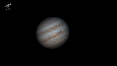
Jupiter, where our Juno mission will begin orbiting on July 4, continues to shine almost as brightly this month as last. And eagle-eyed telescope viewers will see a transit, a shadow transit, an occultation and an eclipse of Jupiter’s moons- all in one night: April 6-7.
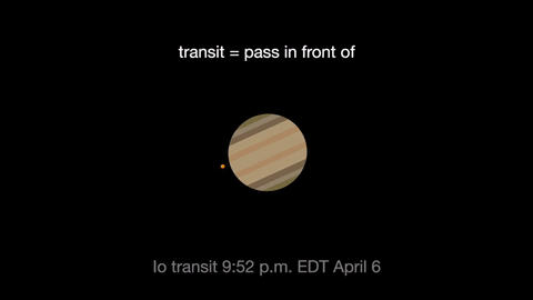
Io transits first, crossing the planet beginning at 9:52 p.m. EDT. It’s shadow can be seen less than an hour later.
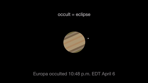
Next Jupiter occults, or eclipses, Europa as Europa slips behind the giant planet at 10:48 p.m. EDT. At 3 a.m. Europa reappears from its eclipse, dramatically leaving the shadow of Jupiter.
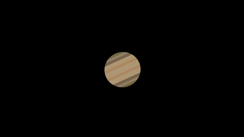
Ganymede transits the planet beginning at 1:01 EDT April 7.
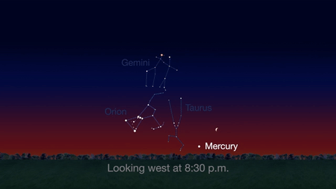
Check out the other planets in April, too! Mercury is always a challenging object to view, but this month you can spot it after sunset about 10 degrees above the horizon. Through a telescope you can see its phase. It will appear like a tiny crescent moon, with about 1/3 of its disk illuminated.
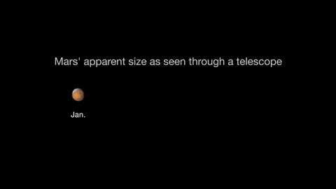
Mars is finally visible before midnight this month. It rises in the southeast at about 10 p.m. by the end of April. The best observing of Mars will be when it is highest in the sky. This means a few hours before dawn. Its brightness and apparent size increase dramatically this month. By month’s end, Mars appears nearly twice as bright as at the beginning of the month.
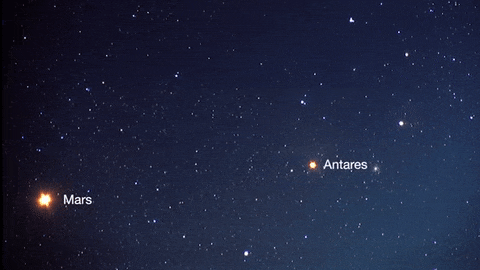
About mid-month you’ll see Mars near its rival in the sky: the similar-colored red supergiant star Antares. The name “Antares” means “equal to or rival of Mars”.
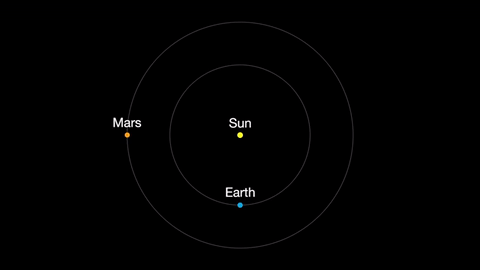
Earth moves almost twice as fast as Mars does, so it often passes Mars in their race around the sun. This causes “retrograde motion”: an illusion we see from our viewpoint on Earth.
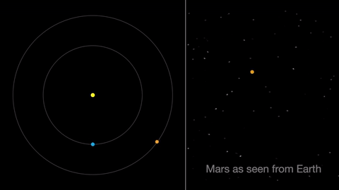
Retrograde motion happens as Earth catches up to Mars, causing Mars to appear slow to slow its eastward motion against the stars. After a few days, when Earth has overtaken Mars, the Red Planet seems to move westward. Eventually, Earth moves far enough around its orbit that Mars appears to be moving eastward again.
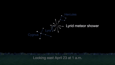
April features one meteor shower, the Lyrids. This year the Lyrids are marred by the full moon. The best time to view will be just before dawn on April 23, when the constellation Lyra is overhead and the moon will be near to setting.
With all of these great things to spot in the sky this month, be sure to get outside and look up!
Make sure to follow us on Tumblr for your regular dose of space: http://nasa.tumblr.com
More Posts from Nasa and Others
Chasing Storms at 17,500mph
Flying 250 miles above the Earth aboard the International Space Station has given me the unique vantage point from which to view our planet. Spending a year in space has given me the unique opportunity to see a wide range of spectacular storm systems in space and on Earth.
The recent blizzard was remarkably visible from space. I took several photos of the first big storm system on Earth of year 2016 as it moved across the East Coast, Chicago and Washington D.C. Since my time here on the space station began in March 2015, I’ve been able to capture an array of storms on Earth and in space, ranging from hurricanes and dust storms to solar storms and most recently a rare thunder snowstorm.

Blizzard 2016

Hurricane Patricia 2015

Hurricane Joaquin 2015

Dust Storm in the Red Sea 2015

Dust Storm of Gobi Desert 2015

Aurora Solar Storm 2015

Aurora Solar Storm 2016

Thunderstorm over Italy 2015

Lightning and Aurora 2016

Rare Thunder Snowstorm 2016
Follow my Year In Space on Twitter, Facebook and Instagram.
One Hot Year after Another
Globally, 2020 was the hottest year on record, effectively tying 2016, the previous record. Overall, Earth’s average temperature has risen more than 2 degrees Fahrenheit since the 1880s.

Temperatures are increasing due to human activities, specifically emissions of greenhouse gases, like carbon dioxide and methane.
Heat and the energy it carries are what drive our planet: winds, weather, droughts, floods, and more are expressions of heat. The right amount of heat is even one of the things that makes life on Earth possible. But too much heat is changing the way our planet’s systems act.
My World’s on Fire
Higher temperatures drive longer, more intense fire seasons. As rain and snowfall patterns change, some regions are getting drier and more vulnerable to damage, setting the stage for more fires.

2020 saw several record-breaking fires, both in Australia in the beginning of the year, and in the western U.S. through northern summer and fall. Smoke from fires in both regions reached so high into the atmosphere that it formed clouds and continues to travel around the globe today.

In the Siberian Arctic, unusually high temperatures helped drive at least 19 fires in the region. More than half of them were burning peat soil -- decomposed organic materials -- that stores a lot of carbon. Peat fires release vast amounts of carbon into the atmosphere, potentially leading to even more warming.

The Water’s Getting Warm
It wasn’t just fire seasons setting records. 2020 had more named tropical storms in the Atlantic and more storms making landfall in the U.S. than any hurricane season on record.

Hurricanes rely on warm ocean water as fuel, and this year, the Atlantic provided. 30 named storms weren’t the only things that made this year’s hurricane season notable.

Storms like Eta, Delta, and Iota quickly changed from smaller, weaker tropical storms into more destructive hurricanes. This rapid intensification is complicated, but it’s likely that warmer, more humid weather -- a result of climate change -- helps drive it.

The Ice Is Getting Thin
Add enough heat, and even the biggest chunk of ice will melt. That’s true whether we’re talking about the ice cubes in your glass or the vast sheets of ice at our planet’s poles. Right now, the Arctic region is warming about three times faster than the rest of our planet, which has some major effects both locally and globally.

This year, Arctic sea ice hit a near-record low. Sea ice is actually made of frozen ocean water, and it grows and thaws with the seasons, typically reaching an annual minimum extent in September.

Warmer ocean water led to more ice melting this year, and 2020’s annual minimum extent continued a long trend of shrinking Arctic sea ice extent.
A Long Trend
We study Earth and how it’s changing from the ground, the sky, and space. Using data from sensors all around the planet, we calculate the global average temperature, working with our partners at NOAA.
Many other organizations also track global temperature using their own instruments and methods, and they all match remarkably well. The last seven years were the hottest seven years on record. Earth is getting warmer.

We also study the effects of increasing temperatures, like the melting sea ice and longer fire seasons mentioned above. Additionally, we can study the cause of climate change from space, with a bird’s eye view of increasing carbon in the atmosphere.

The planet is changing because of human activities. We’re working together with other agencies to monitor changes and understand what this means for people in the future.
Make sure to follow us on Tumblr for your regular dose of space: http://nasa.tumblr.com.
Frozen: Ice on Earth and Well Beyond

Icy Hearts: A heart-shaped calving front of a glacier in Greenland (left) and Pluto's frozen plains (right). Credits: NASA/Maria-Jose Viñas and NASA/APL/SwRI
From deep below the soil at Earth’s polar regions to Pluto’s frozen heart, ice exists all over the solar system...and beyond. From right here on our home planet to moons and planets millions of miles away, we’re exploring ice and watching how it changes. Here’s 10 things to know:
1. Earth’s Changing Ice Sheets

An Antarctic ice sheet. Credit: NASA
Ice sheets are massive expanses of ice that stay frozen from year to year and cover more than 6 million square miles. On Earth, ice sheets extend across most of Greenland and Antarctica. These two ice sheets contain more than 99 percent of the planet’s freshwater ice. However, our ice sheets are sensitive to the changing climate.
Data from our GRACE satellites show that the land ice sheets in both Antarctica and Greenland have been losing mass since at least 2002, and the speed at which they’re losing mass is accelerating.
2. Sea Ice at Earth’s Poles

Earth’s polar oceans are covered by stretches of ice that freezes and melts with the seasons and moves with the wind and ocean currents. During the autumn and winter, the sea ice grows until it reaches an annual maximum extent, and then melts back to an annual minimum at the end of summer. Sea ice plays a crucial role in regulating climate – it’s much more reflective than the dark ocean water, reflecting up to 70 percent of sunlight back into space; in contrast, the ocean reflects only about 7 percent of the sunlight that reaches it. Sea ice also acts like an insulating blanket on top of the polar oceans, keeping the polar wintertime oceans warm and the atmosphere cool.
Some Arctic sea ice has survived multiple years of summer melt, but our research indicates there’s less and less of this older ice each year. The maximum and minimum extents are shrinking, too. Summertime sea ice in the Arctic Ocean now routinely covers about 30-40 percent less area than it did in the late 1970s, when near-continuous satellite observations began. These changes in sea ice conditions enhance the rate of warming in the Arctic, already in progress as more sunlight is absorbed by the ocean and more heat is put into the atmosphere from the ocean, all of which may ultimately affect global weather patterns.
3. Snow Cover on Earth

Snow extends the cryosphere from the poles and into more temperate regions.
Snow and ice cover most of Earth’s polar regions throughout the year, but the coverage at lower latitudes depends on the season and elevation. High-elevation landscapes such as the Tibetan Plateau and the Andes and Rocky Mountains maintain some snow cover almost year-round. In the Northern Hemisphere, snow cover is more variable and extensive than in the Southern Hemisphere.
Snow cover the most reflective surface on Earth and works like sea ice to help cool our climate. As it melts with the seasons, it provides drinking water to communities around the planet.
4. Permafrost on Earth

Tundra polygons on Alaska's North Slope. As permafrost thaws, this area is likely to be a source of atmospheric carbon before 2100. Credit: NASA/JPL-Caltech/Charles Miller
Permafrost is soil that stays frozen solid for at least two years in a row. It occurs in the Arctic, Antarctic and high in the mountains, even in some tropical latitudes. The Arctic’s frozen layer of soil can extend more than 200 feet below the surface. It acts like cold storage for dead organic matter – plants and animals.
In parts of the Arctic, permafrost is thawing, which makes the ground wobbly and unstable and can also release those organic materials from their icy storage. As the permafrost thaws, tiny microbes in the soil wake back up and begin digesting these newly accessible organic materials, releasing carbon dioxide and methane, two greenhouse gases, into the atmosphere.
Two campaigns, CARVE and ABoVE, study Arctic permafrost and its potential effects on the climate as it thaws.
5. Glaciers on the Move

Did you know glaciers are constantly moving? The masses of ice act like slow-motion rivers, flowing under their own weight. Glaciers are formed by falling snow that accumulates over time and the slow, steady creep of flowing ice. About 10 percent of land area on Earth is covered with glacial ice, in Greenland, Antarctica and high in mountain ranges; glaciers store much of the world's freshwater.
Our satellites and airplanes have a bird’s eye view of these glaciers and have watched the ice thin and their flows accelerate, dumping more freshwater ice into the ocean, raising sea level.
6. Pluto’s Icy Heart

The nitrogen ice glaciers on Pluto appear to carry an intriguing cargo: numerous, isolated hills that may be fragments of water ice from Pluto's surrounding uplands. NASA/Johns Hopkins University Applied Physics Laboratory/Southwest Research Institute
Pluto’s most famous feature – that heart! – is stone cold. First spotted by our New Horizons spacecraft in 2015, the heart’s western lobe, officially named Sputnik Planitia, is a deep basin containing three kinds of ices – frozen nitrogen, methane and carbon monoxide.
Models of Pluto’s temperatures show that, due the dwarf planet’s extreme tilt (119 degrees compared to Earth’s 23 degrees), over the course of its 248-year orbit, the latitudes near 30 degrees north and south are the coldest places – far colder than the poles. Ice would have naturally formed around these latitudes, including at the center of Sputnik Planitia.
New Horizons also saw strange ice formations resembling giant knife blades. This “bladed terrain” contains structures as tall as skyscrapers and made almost entirely of methane ice, likely formed as erosion wore away their surfaces, leaving dramatic crests and sharp divides. Similar structures can be found in high-altitude snowfields along Earth’s equator, though on a very different scale.
7. Polar Ice on Mars

This image, combining data from two instruments aboard our Mars Global Surveyor, depicts an orbital view of the north polar region of Mars. Credit: NASA/JPL-Caltech/MSSS
Mars has bright polar caps of ice easily visible from telescopes on Earth. A seasonal cover of carbon dioxide ice and snow advances and retreats over the poles during the Martian year, much like snow cover on Earth.

This animation shows a side-by-side comparison of CO2 ice at the north (left) and south (right) Martian poles over the course of a typical year (two Earth years). This simulation isn't based on photos; instead, the data used to create it came from two infrared instruments capable of studying the poles even when they're in complete darkness. This data were collected by our Mars Reconnaissance Orbiter, and Mars Global Surveyor. Credit: NASA/JPL-Caltech
During summertime in the planet's north, the remaining northern polar cap is all water ice; the southern cap is water ice as well, but remains covered by a relatively thin layer of carbon dioxide ice even in summertime.
Scientists using radar data from our Mars Reconnaissance Orbiter found a record of the most recent Martian ice age in the planet's north polar ice cap. Research indicates a glacial period ended there about 400,000 years ago. Understanding seasonal ice behavior on Mars helps scientists refine models of the Red Planet's past and future climate.
8. Ice Feeds a Ring of Saturn

Wispy fingers of bright, icy material reach tens of thousands of kilometers outward from Saturn's moon Enceladus into the E ring, while the moon's active south polar jets continue to fire away. Credit: NASA/JPL/Space Science Institute
Saturn’s rings and many of its moons are composed of mostly water ice – and one of its moons is actually creating a ring. Enceladus, an icy Saturnian moon, is covered in “tiger stripes.” These long cracks at Enceladus’ South Pole are venting its liquid ocean into space and creating a cloud of fine ice particles over the moon's South Pole. Those particles, in turn, form Saturn’s E ring, which spans from about 75,000 miles (120,000 kilometers) to about 260,000 miles (420,000 kilometers) above Saturn's equator. Our Cassini spacecraft discovered this venting process and took high-resolution images of the system.

Jets of icy particles burst from Saturn’s moon Enceladus in this brief movie sequence of four images taken on Nov. 27, 2005. Credit: NASA/JPL/Space Science Institute
9. Ice Rafts on Europa

View of a small region of the thin, disrupted, ice crust in the Conamara region of Jupiter's moon Europa showing the interplay of surface color with ice structures. Credit: NASA/JPL/University of Arizona
The icy surface of Jupiter’s moon Europa is crisscrossed by long fractures. During its flybys of Europa, our Galileo spacecraft observed icy domes and ridges, as well as disrupted terrain including crustal plates that are thought to have broken apart and "rafted" into new positions. An ocean with an estimated depth of 40 to 100 miles (60 to 150 kilometers) is believed to lie below that 10- to 15-mile-thick (15 to 25 km) shell of ice.
The rafts, strange pits and domes suggest that Europa’s surface ice could be slowly turning over due to heat from below. Our Europa Clipper mission, targeted to launch in 2022, will conduct detailed reconnaissance of Europa to see whether the icy moon could harbor conditions suitable for life.
10. Crater Ice on Our Moon

The image shows the distribution of surface ice at the Moon’s south pole (left) and north pole (right), detected by our Moon Mineralogy Mapper instrument. Credit: NASA
In the darkest and coldest parts of our Moon, scientists directly observed definitive evidence of water ice. These ice deposits are patchy and could be ancient. Most of the water ice lies inside the shadows of craters near the poles, where the warmest temperatures never reach above -250 degrees Fahrenheit. Because of the very small tilt of the Moon’s rotation axis, sunlight never reaches these regions.
A team of scientists used data from a our instrument on India’s Chandrayaan-1 spacecraft to identify specific signatures that definitively prove the water ice. The Moon Mineralogy Mapper not only picked up the reflective properties we’d expect from ice, but was able to directly measure the distinctive way its molecules absorb infrared light, so it can differentiate between liquid water or vapor and solid ice.
With enough ice sitting at the surface – within the top few millimeters – water would possibly be accessible as a resource for future expeditions to explore and even stay on the Moon, and potentially easier to access than the water detected beneath the Moon’s surface.
11. Bonus: Icy World Beyond Our Solar System!

With an estimated temperature of just 50K, OGLE-2005-BLG-390L b is the chilliest exoplanet yet discovered. Pictured here is an artist's concept. Credit: NASA
OGLE-2005-BLG-390Lb, the icy exoplanet otherwise known as Hoth, orbits a star more than 20,000 light years away and close to the center of our Milky Way galaxy. It’s locked in the deepest of deep freezes, with a surface temperature estimated at minus 364 degrees Fahrenheit (minus 220 Celsius)!
Make sure to follow us on Tumblr for your regular dose of space: http://nasa.tumblr.com.
Photos of the eclipse are okay and just as neat to look at? Will NASA post to twitter. Will the Space station take photos also?
Yes, we will be posting a ton of photos and you can add to them as well! https://www.flickr.com/groups/nasa-eclipse2017/ I agree, the photos are incredibly cool!
The Birth of a New Island

In late December 2014, an underwater volcano in the South Pacific Kingdom of Tonga erupted and sent a violent stream of steam, ash and rock into the air. The ash plumes rose as high as 30,000 feet (9 kilometers) into the sky and diverted airline flights.
Most new oceanic islands often wash away quickly within a few months. The island doesn't have an official name, and is referred to as Hunga Tonga-Hunga Ha'apai after two older islands to either side.
But this island was different. One of our satellites that detects volcanic eruptions alerted our scientists who were very excited because this type of explosive, undersea eruption is rare. In fact, the new Tongan island is one of only three of this kind of volcanic islands in the past 150 years to emerge and survive. It's now three years old.
Zooming in from Space

The baby island is also the first of its kind to emerge in the modern satellite era. This is really important since it's difficult to send our researchers the South Pacific every month to see how the island has changed – which it did very rapidly, especially in the first six months. But satellites in space delivered monthly views which we used to make these high resolution, 3-D topographic maps. With these maps, we tracked the early life and evolution of the island in unprecedented detail.

In April 2015, we watched an isthmus bridge begin forming from the new island to the older island neighboring it to the east. Soft volcanic material, especially on the island's southern side, was eroded by the ocean and deposited on the tail end, which grew and grew till it reached the other island. It's about 1600 feet (500 meters) across, or the length of 5 football fields.

The erosive forces of the ocean broke down the southern wall of the crater lake in May 2015. We thought this might mean that the island wouldn't last much longer because the ocean could now attack the interior of the island's tuff cone. But in June, a sandbar formed, closing off the lake again and protecting the interior. The sandbar has been in place ever since.
Monitoring these changes of both erosion and growth, we now believe that the island will last from between 6 to 30 years!
Terranauts!

Why has the island survived for three years? What makes eroding it away harder than for other blink-and-you-miss-it oceanic islands that disappear into the sea after a few months? To answer these questions, we need rock samples.
Working with the Tongan government, we recruited two French citizens sailing around the world who were in Tongan waters in June, 2017, to go to the new island on our behalf. We treated them like astronauts and gave them instructions to take pictures and samples of the volcanic rocks at locations we could see from space along the coasts, the interior of the crater lake, and from the top of the tuff cone.

They did a fantastic job documenting each sample and where it came from, and then mailed the box of rocks back to our team at our Goddard Space Flight Center in Greenbelt, Maryland, where they are currently being analyzed. We believe that after the eruption, warm seawater mixed with volcanic ash to chemically alter it so that when it hardened into rock it was a tougher material. We're excited to see if the rock samples confirm this.
From Earth to Mars

Link: https://svs.gsfc.nasa.gov/11372
Did these Martian volcanoes form in an ocean or lake? If they did, wet environments such as these combined with heat from volcanic processes may be prime locations to search for evidence of past life. We may not know until we arrive on the red planet, but by studying Earth's landforms, we'll be better prepared when we do.
Make sure to follow us on Tumblr for your regular dose of space: http://nasa.tumblr.com.

NASA Spotlight: Astronaut Soichi Noguchi
Soichi Noguchi was selected as an astronaut with the Japan Aerospace Exploration Agency in 1996. A native of Yokohama, Kanagawa, he is currently a mission specialist for NASA’s SpaceX Crew-1 launch taking flight to the International Space Station on Nov. 14. Soichi will be the first international crewmember on Crew Dragon and the first international partner astronaut to fly aboard three types of orbital spacecraft – the U.S. space shuttle, the Russian Soyuz, and now the SpaceX Crew Dragon! Talk about impressive. He received a B.S. in Aeronautical Engineering in 1989, master's degree in Aeronautical Engineering in 1991, Doctor of Philosophy in Advanced Interdisciplinary Studies in 2020, all from the University of Tokyo.
Soichi took time from preparing for his historic mission to answer questions about his life and career:
You recently earned a doctorate in philosophy. What made you do it?
After my second flight, I started this research about your sensory system in zero gravity. I used a my own personal video, which I took during my last two flights at the International Space Station. I had a lot of interesting discussions amongst young professionals and students at the University of Tokyo about the research. It was a fun experience – but I would not do it again!
Space is a risky business. Why do it?
Space IS definitely a risky business. But the reward is higher than the risk so that’s why we take it.
Do you have a message for boys and girls in Japan who are interested in science and engineering?
Three words: Space. Is. Waiting.

Aside from mission objectives and tasks, what’s a personal goal for this mission?
We have a lot of interesting missions to do, but my personal goal is to return home with lots of fun stories.

What was it like to get the phone call to become an astronaut?
It was 25 years ago, but I still remember the voice vividly. I got a call from Dr. Mamoru Mohri, the very first JAXA astronaut, and he said “Welcome to the Astronaut Corps.” When I got the call to be part of the Crew-1 mission, I was a lot less nervous than when I was assigned to my first mission, but the excitement remains the same.
Can you describe your crew mate Mike Hopkins in one sentence?
He is a natural leader that takes care of the team really well, and he’s fun to play around with.

Star Trek or Star Wars?
Star Wars… just because!

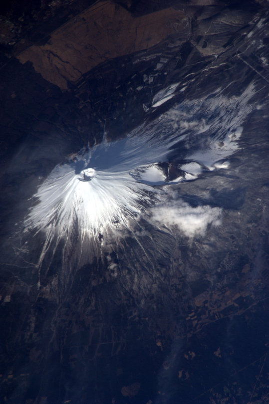
Can you share your favorite photo or video that you took in space?
My favorite photo is Mount Fuji because I see the mountain almost every day when I was a child. It’s definitely breathtaking to see Mount Fuji from space.
What personal items did you decide to pack for launch and why?
I have lots of family photos, and I would put it inside my sleep station. Definitely one of the most challenging things about spaceflight is not experiencing zero gravity, not the rocket, but time away from family.
How would you describe spacewalking outside the space station?
It’s an excursion. The view of the Earth is just breathtaking because you are just one glass away from the vacuum of space. There’s nothing between you and Earth.

What are you most excited about for the future of human space exploration?
I would say I’m most excited for interplanetary travel to become more common so that the school kids can go to Mars on their field trip.
What would you say to someone looking to follow in your footsteps?
Don’t worry, be happy!
How has spaceflight evolved since your first launch and stay aboard the International Space Station in 2005?
This is definitely an exciting moment. We’re starting to see more players in the game. SpaceX is the frontrunner, but soon we’ll see Boeing, Sierra Nevada and Axiom. So the International Space Station will soon have more players involved, and it will be a lot more fun!
Thank you for your time, Soichi, and good luck on your historic mission! Get to know a bit more about Soichi and his NASA astronaut crew mates Victor Glover, Michael Hopkins, and Shannon Walker in the video above.
Watch LIVE launch coverage beginning at 3:30 p.m. EST on Nov. 14 HERE.
Make sure to follow us on Tumblr for your regular dose of space: http://nasa.tumblr.com
How do you guys help with climate change?
What's a Question you wish someone would ask?
What Are the Bright Spots on Ceres?

Dwarf planet Ceres has more than 130 bright areas, and most of them are associated with impact craters. Now, Ceres has revealed some of its well-kept secrets in two new studies in the journal Nature, thanks to data from our Dawn spacecraft.
Two studies have been looking into the mystery behind these bright areas. One study identifies this bright material as a kind of salt, while the other study suggests the detection of ammonia-rich clays.
Study authors write that the bright material is consistent with a type of magnesium sulfate called hexahydrite. A different type of magnesium sulfate is familiar on Earth as Epsom salt.

Researchers, using images from Dawn’s framing camera, suggest that these salt-rich areas were left behind when water-ice sublimated in the past. Impacts from asteroids would have unearthed the mixture of ice and salt.
An image of Occator Crater (below) shows the brightest material on Ceres. Occator itself is 60 miles in diameter, and its central pit, covered by this bright material, measures about 6 miles wide. With its sharp rim and walls, it appears to be among the youngest features on the dwarf planet.

In the second nature study, members of the Dawn science team examined the composition of Ceres and found evidence for ammonia-rich clays. Why is this important?
Well, ammonia ice by itself would evaporate on Ceres today, because it is too warm. However, ammonia molecules could be stable if present in combination with other minerals. This raises the possibility that Ceres did not originate in the main asteroid belt between Mars and Jupiter, where it currently resides. But instead, might have formed in the outer solar system! Another idea is that Ceres formed close to its present position, incorporating materials that drifted in from the outer solar system, near the orbit of Neptune, where nitrogen ices are thermally stable.

As of this week, our Dawn spacecraft has reached its final orbital altitude at Ceres (about 240 miles from the surface). In mid-December, it will begin taking observations from this orbit, so be sure to check back for details!
ake sure to follow us on Tumblr for your regular dose of space: http://nasa.tumblr.com
Celebrate #BlackHoleFriday with Nurturing Baby Stars

Are you throwing all your money into a black hole today?
Forget Black Friday — celebrate #BlackHoleFriday with us and get sucked into this recent discovery of a black hole that may have sparked star births across multiple galaxies.
If confirmed, this discovery would represent the widest reach ever seen for a black hole acting as a stellar kick-starter — enhancing star formation more than one million light-years away. (One light year is equal to 6 trillion miles.)
A black hole is an extremely dense object from which no light can escape. The black hole's immense gravity pulls in surrounding gas and dust. Sometimes, black holes hinder star birth. Sometimes — like perhaps in this case — they increase star birth.
Telescopes like our Chandra X-ray Observatory help us detect the X-rays produced by hot gas swirling around the black hole. Have more questions about black holes? Click here to learn more.
Make sure to follow us on Tumblr for your regular dose of space: http://nasa.tumblr.com.
-
 carryonmycobaltangel liked this · 1 year ago
 -
 pepperface97 reblogged this · 8 years ago
 -
pepperface97 liked this · 8 years ago
-
 onceagwen liked this · 8 years ago
 -
 fridaatzin95 liked this · 9 years ago
 -
 jsclark1969-blog liked this · 9 years ago
 -
 addycted liked this · 9 years ago
 -
 safouane-reus liked this · 9 years ago
 -
 doodlenova liked this · 9 years ago
 -
 bigbluenasa reblogged this · 9 years ago
 -
 santelmosundowner-blog reblogged this · 9 years ago
 -
 spaceplasma liked this · 9 years ago
 -
 halforcdad liked this · 9 years ago
 -
 satousei13 liked this · 9 years ago
 -
 samsgroves reblogged this · 9 years ago
 -
 iamdelph reblogged this · 9 years ago
 -
 durtschi liked this · 9 years ago
 -
 smothernights liked this · 9 years ago
 -
 scullywolf liked this · 9 years ago
 -
 dialmformara reblogged this · 9 years ago
 -
 allegoricalrose liked this · 9 years ago
 -
 pinchtheprincess liked this · 9 years ago
 -
 tripwirealarm reblogged this · 9 years ago
 -
 onceuponaknittery liked this · 9 years ago
 -
 mrwyx liked this · 9 years ago
 -
 pirateprincessyuki reblogged this · 9 years ago
 -
 ghoulish-activist-gay reblogged this · 9 years ago
 -
ghoulish-activist-gay liked this · 9 years ago
-
 evanthelynn reblogged this · 9 years ago
 -
 pwdmt reblogged this · 9 years ago
 -
pwdmt liked this · 9 years ago
-
 prayingforpolya-blog liked this · 9 years ago
 -
 kushiro-shiina-blog liked this · 9 years ago
 -
 sosayset reblogged this · 9 years ago
 -
 fabio-tolio reblogged this · 9 years ago
Explore the universe and discover our home planet with the official NASA Tumblr account
1K posts