Friday Stroll? How About A Spacewalk?
Friday Stroll? How About a Spacewalk?
On Friday, May 12, NASA astronauts Peggy Whitson and Jack Fischer will venture outside the International Space Station, into the vacuum of space, for a spacewalk.

Space Fact: This will be the 200th spacewalk performed on the space station!
You can watch their entire 6.5 hour spacewalk live online! (Viewing info below!) To tell the two astronauts apart in their bulky spacewalk suits, Whitson will be wearing the suit with red stripes, while Jack Fischer will have white stripes.

Space Fact: The first-ever spacewalk on the International Space Station was performed on Dec. 7, 1998.
For Peggy, this will be her ninth spacewalk! She actually holds the record for most spacewalks by a female astronaut. For Fischer, this is his first time in space, and will be his first spacewalk. You can see from the below Tweet, he’s pretty excited!

Once both astronauts venture outside the Quest airlock, their tasks will focus on:
Replacing a large avionic box that supplies electricity and data connections to the science experiments
Replacing hardware stored outside the station
Specifically, the ExPRESS Carrier Avionics, or ExPCA will be replaced with a unit delivered to the station last month aboard the Orbital ATK Cygnus cargo spacecraft.

Ever wonder how astronauts prepare and practice for these activities? Think about it, wearing a bulky spacesuit (with gloves!), floating in the vacuum of space, PLUS you have to perform complex tasks for a period of ~6.5 hours!
In order to train on Earth, astronauts complete tasks in our Neutral Buoyancy Laboratory (NBL). It’s a gigantic pool with a full mock up of the International Space Station! Here’s a clip of astronauts practicing to install the ExPCA in that practice pool at Johnson Space Center in Houston.

In addition, Whitson and Fischer will install a connector that will route data to the Alpha Magnetic Spectrometer and help the crew determine the most efficient way to conduct future maintenance on the cosmic ray detector.

The astronauts will also install a protective shield on the Pressurized Mating Adapter-3, which was moved in March. This adapter will host a new international docking port for the arrival of commercial crew spacecraft.

Finally, the duo will rig a new high-definition camera and pair of wireless antennas to the exterior of the outpost.
Watch the Spacewalk Live!

Live coverage will begin at 6:30 a.m. EDT, with spacewalk activities starting at 8 a.m. EDT.
Stream the entire spacewalk live online at nasa.gov/live
OR
Watch live on the International Space Station Facebook page starting at 7:00 a.m. EDT
Make sure to follow us on Tumblr for your regular dose of space: http://nasa.tumblr.com
More Posts from Nasa and Others
What popular film is the closest to reality for you?
They Put a Flag on the Moon

It’s 1969 and Apollo 11 astronauts Buzz Aldrin and Neil Armstrong are the first humans to land on the Moon. In now iconic footage, Aldrin and Armstrong carefully assemble and maneuver an American flag to place on the lunar surface. The fabric unfurls, staying suspended without any wind to animate the stars and stripes. The flagpole sways precariously as the crew work to anchor it in the Moon’s low gravity at just 1/6th that of Earth’s. How did this moment come about? On Flag Day, let’s dive behind-the-scenes of what led to getting the American flag on the Moon 50 years ago.

Image: Astronaut Buzz Aldrin poses for a photograph beside the deployed United States flag during the Apollo 11 mission.
Seeking to empower the nation, President John F. Kennedy gave us a grand charge. The human spaceflight program of the early 1960s was challenged to work on missions that sent humans to the surface of another world. Following President Kennedy’s death in 1963, President Richard Nixon stressed a more international perspective to the Apollo missions. To reconcile the need for global diplomacy with national interests, we appointed the Committee on Symbolic Activities for the First Lunar Landing.

Image: NASA Administrator Thomas Paine and President Richard Nixon are seen aboard the USS Hornet, Apollo 11’s splashdown recovery vessel.
The committee, and the U.S. at large, wanted to avoid violating the United Nations Outer Space Treaty, which prohibited any nation from taking possession of a celestial body. After some debate, they recommended that the flag only appear during the Apollo 11 spacewalk. A plaque would accompany it, explaining that the flag was meant to stand for peaceful exploration, not conquest.

Image: The plaque reads “Here men from the planet Earth first set foot upon the Moon July 1969 A.D. We came in peace for all of mankind.” Under the text are signatures by President Nixon, Buzz Aldrin, Neil Armstrong, and Michael Collins.
A team of engineers at Johnson Space Center had three months to resolve several issues regarding the flag’s assembly. First, was the Moon’s lack of atmosphere. The flag, quite literally, could not fly the way it does on Earth. To address this, a horizontal crossbar was added to support the flag’s weight and give the illusion of it waving.

Image: NASA technician David L. McCraw shows the flag next to a Lunar Module mockup.
Second was the flag’s assembly, which had to be as lightweight and compact as possible so as not to take up limited storage space. The completed package, which was attached to Lunar Module’s ladder, weighed just under ten pounds. It received an outer case made of steel, aluminum, and Thermoflex insulation and blanketing to shield the flag from the 2,000 degree Fahrenheit spike from the Eagle’s descent engine.

Image: Component pieces of the flag assembly.
The last issue was mobility. Bulky spacesuits significantly restricted the astronauts’ range of motion, and suit pressurization limited how much force they could apply. To accommodate these limits, the team included telescoping components to minimize the need to reach and maneuver the poles. A red painted ring on the flagpole indicated how far into the ground it should be driven. Hinges and catches would lock into place once the pieces were fully extended.

Image: Diagram from the 1969 Apollo 11 press release illustrating astronaut spacesuit reach capabilities and ideal working height.
Fifty years after Apollo 11, the flag we planted on the lunar surface has likely faded but its presence looms large in United States history as a symbol of American progress and innovation.

Image: A close-up view of the U.S. flag deployed on the Moon at the Taurus-by the crew of Apollo 17, the most recent lunar landing mission.
The story doesn’t stop here. Anne Platoff's article “Where No Flag Has Gone Before” sheds more light on the context and technical process of putting the United States flag on the Moon. You can also check out Johnson Space Center’s recent feature story that details its presence in later missions. Happy Flag Day! Make sure to follow us on Tumblr for your regular dose of space: http://nasa.tumblr.com.
How Do Hurricanes Form?
Hurricanes are the most violent storms on Earth. People call these storms by other names, such as typhoons or cyclones, depending on where they occur.

The scientific term for ALL of these storms is tropical cyclone. Only tropical cyclones that form over the Atlantic Ocean or eastern and central Pacific Ocean are called “hurricanes.”

Whatever they are called, tropical cyclones all form the same way.
Tropical cyclones are like giant engines that use warm, moist air as fuel. That is why they form only over warm ocean waters near the equator. This warm, moist air rises and condenses to form clouds and storms.

As this warmer, moister air rises, there's less air left near the Earth's surface. Essentially, as this warm air rises, this causes an area of lower air pressure below.

This starts the 'engine' of the storm. To fill in the low pressure area, air from surrounding areas with higher air pressure pushes in. That “new” air near the Earth's surface also gets heated by the warm ocean water so it also gets warmer and moister and then it rises.

As the warm air continues to rise, the surrounding air swirls in to take its place. The whole system of clouds and wind spins and grows, fed by the ocean’s heat and water evaporating from the surface.
As the storm system rotates faster and faster, an eye forms in the center. It is vey calm and clear in the eye, with very low air pressure.

Tropical cyclones usually weaken when they hit land, because they are no longer being “fed” by the energy from the warm ocean waters. However, when they move inland, they can drop many inches of rain causing flooding as well as wind damage before they die out completely.
There are five types, or categories, of hurricanes. The scale of categories is called the Saffir-Simpson Hurricane Scale and they are based on wind speed.

How Does NASA Study Hurricanes?
Our satellites gather information from space that are made into pictures. Some satellite instruments measure cloud and ocean temperatures. Others measure the height of clouds and how fast rain is falling. Still others measure the speed and direction of winds.

We also fly airplanes into and above hurricanes. The instruments aboard planes gather details about the storm. Some parts are too dangerous for people to fly into. To study these parts, we use airplanes that operate without people.
Learn more about this and other questions by exploring NASA Space Place and the NASA/NOAA SciJinks that offer explanations of science topics for school kids.
Make sure to follow us on Tumblr for your regular dose of space: http://nasa.tumblr.com.
Credits: NASA Space Place & NASA/NOAA SciJinks
Solar System: Things to Know This Week
Our solar system is huge, let us break it down for you. Here are a few things to know this week:
1. The View from the Far Shore

The rugged shores of Pluto’s highlands come into sharp view in a newly released image from our New Horizons spacecraft. This latest view zooms in on the southeastern portion of Pluto’s great ice plains, where they border dark highlands formerly named Krun Macula.
2. Dawn’s Latest Light

Our Dawn mission has now completed more than 1,000 orbital revolutions since entering into Ceres’ gravitational grip in March 2015. The probe is healthy and performing its ambitious assignments impeccably. See what it has revealed lately HERE.
3. Counting Down

Our OSIRIS-REx mission to the asteroid Bennu is now entering the final preparations for its planned launch in September. In a new interview, the mission’s principal investigator reports on the final pre-flight tests happening at our Kennedy Space Center in Florida.
4. Deep Dive

Three successful engine maneuvers to bring the lowest part of the spacecraft’s orbit down to just 74 miles (119 km) above the surface of Mars, the MAVEN mission’s fifth deep dip campaign has begun. MAVEN is studying the planet’s atmosphere up close.
5. Storm Season

Meanwhile, other robotic Mars orbiters have revealed that a pattern of three large regional dust storms occurs with similar timing most Martian years. The seasonal pattern was detected from dust storms’ effects on atmospheric temperatures, which spacecraft have been monitoring since 1997.
Want to learn more? Read our full list of the 10 things to know this week about the solar system HERE.
Make sure to follow us on Tumblr for your regular dose of space: http://nasa.tumblr.com
What are Gravitational Waves?
Today, the National Science Foundation (NSF) announced the detection of gravitational waves by the Laser Interferometer Gravitational-Wave Observatory (LIGO), a pair of ground-based observatories. But...what are gravitational waves? Let us explain:

Gravitational waves are disturbances in space-time, the very fabric of the universe, that travel at the speed of light. The waves are emitted by any mass that is changing speed or direction. The simplest example is a binary system, where a pair of stars or compact objects (like black holes) orbit their common center of mass.

We can think of gravitational effects as curvatures in space-time. Earth’s gravity is constant and produces a static curve in space-time. A gravitational wave is a curvature that moves through space-time much like a water wave moves across the surface of a lake. It is generated only when masses are speeding up, slowing down or changing direction.
Did you know Earth also gives off gravitational waves? Earth orbits the sun, which means its direction is always changing, so it does generate gravitational waves, although extremely weak and faint.
What do we learn from these waves?
Observing gravitational waves would be a huge step forward in our understanding of the evolution of the universe, and how large-scale structures, like galaxies and galaxy clusters, are formed.
Gravitational waves can travel across the universe without being impeded by intervening dust and gas. These waves could also provide information about massive objects, such as black holes, that do not themselves emit light and would be undetectable with traditional telescopes.

Just as we need both ground-based and space-based optical telescopes, we need both kinds of gravitational wave observatories to study different wavelengths. Each type complements the other.
Ground-based: For optical telescopes, Earth’s atmosphere prevents some wavelengths from reaching the ground and distorts the light that does.
Space-based: Telescopes in space have a clear, steady view. That said, telescopes on the ground can be much larger than anything ever launched into space, so they can capture more light from faint objects.
How does this relate to Einstein’s theory of relativity?
The direct detection of gravitational waves is the last major prediction of Einstein’s theory to be proven. Direct detection of these waves will allow scientists to test specific predictions of the theory under conditions that have not been observed to date, such as in very strong gravitational fields.
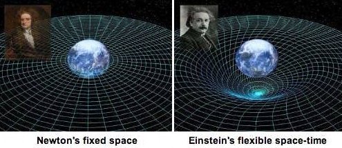
In everyday language, “theory” means something different than it does to scientists. For scientists, the word refers to a system of ideas that explains observations and experimental results through independent general principles. Isaac Newton's theory of gravity has limitations we can measure by, say, long-term observations of the motion of the planet Mercury. Einstein's relativity theory explains these and other measurements. We recognize that Newton's theory is incomplete when we make sufficiently sensitive measurements. This is likely also true for relativity, and gravitational waves may help us understand where it becomes incomplete.
Make sure to follow us on Tumblr for your regular dose of space: http://nasa.tumblr.com
Tournament Earth: The Earthly Eight
To celebrate Earth Observatory’s 20th anniversary and the 50th anniversary of Earth Day, we asked readers to pick our all-time best image. We have already completed two rounds of voting, which led to two rounds of stunning upsets. As we head into round 3, only two of the top eight seeds (#1s and #2s) remain. It is time now to cast your votes for the best of the Earthly 8. Voting ends on April 13 at 9 a.m. U.S. Eastern Time.
The nominees are separated into four groups: Past Winners, Home Planet, Land & Ice, and Sea & Sky. Check out the contenders still in the game:
Past Winners: Ocean Sand, Bahamas (#5 seed) vs. A View from Saturn (#2 seed)
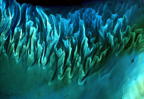
Though the above image may resemble a new age painting straight out of an art gallery in Venice Beach, California, it is in fact a satellite image of the sands and seaweed in the Bahamas. The image was taken by the Enhanced Thematic Mapper plus (ETM+) instrument aboard the Landsat 7 satellite. Tides and ocean currents in the Bahamas sculpted the sand and seaweed beds into these multicolored, fluted patterns in much the same way that winds sculpted the vast sand dunes in the Sahara Desert.

This beautiful image of Saturn and its rings looks more like an artist’s creation than a real image, but in fact, the image is a composite (layered image) made from 165 images taken by the wide-angle camera on the Cassini spacecraft over nearly three hours on September 15, 2006. Scientists created the color in the image by digitally compositing ultraviolet, infrared, and clear-filter images and then adjusting the final image to resemble natural color. (A clear filter is one that allows in all the wavelengths of light the sensor is capable of detecting.) This image is a closeup view of the upper left quadrant of the rings, through which Earth is visible in the far, far distance. The full image can be seen here.
Home Planet: Twin Marbles (#1 seed) vs. Fire in the Sky and on the Ground (#7 seed)

A day’s clouds. The shape and texture of the land. The living ocean. City lights as a beacon of human presence across the globe. This amazingly beautiful view of Earth from space is a fusion of science and art, a showcase for the remote-sensing technology that makes such views possible, and a testament to the passion and creativity of the scientists who devote their careers to understanding how land, ocean, and atmosphere—even life itself—interact to generate Earth’s unique (as far as we know!) life-sustaining environment.

Astronauts on the International Space Station (ISS) used a digital camera to capture several hundred photographs of the aurora australis, or “southern lights,” while passing over the Indian Ocean on September 17, 2011. If you click on this movie, you can see the flowing ribbons and rays below as the ISS passed from south of Madagascar to just north of Australia between 17:22 and 17:45 Universal Time. Solar panels and other sections of the ISS fill some of the upper right side of the photograph.
Auroras are a spectacular sign that our planet is electrically and magnetically connected to the Sun. These light shows are provoked by energy from the Sun and fueled by electrically charged particles trapped in Earth’s magnetic field, or magnetosphere. In this case, the space around Earth was stirred up by an explosion of hot, ionized gas from the Sun—a coronal mass ejection—that left the Sun on September 14, 2011.
Ice and Land: Sand Dunes (#8 seed) vs. Retreat of Columbia Glacier (#6 seed)

Mountains of sand, some as tall as 300 meters (1000 feet), reach from the floor of Africa’s Namib Desert toward the sky. Driven by wind, these dunes march across the desert, bordered to the west by the Atlantic Ocean and in other directions by solid, rocky land.
The abrupt transition from sand to land is visible in this image, acquired on November 13, 2019, by the Operational Land Imager (OLI) on Landsat 8. They show the northern extent of the Namib Sand Sea—a field of sand dunes spanning more than 3 million hectares (more than 10,000 square miles) within the Namib-Naukluft Park, which was named a UNESCO World Heritage site in 2013. Sand appears red, painted by a layer of iron oxide.


Scientists have long studied Alaska's fast-moving Columbia Glacier, a tidewater glacier that descends through the Chugach Mountains into Prince William Sound. Yet the river of ice continues to deliver new surprises.
The image series begins in July 1986 (bottom image) with a false-color image captured by the Thematic Mapper (TM) sensor on the Landsat 5 satellite. The false-color image from July 2014 (top image), acquired by the Operational Land Imager on the Landsat 8 satellite, shows the extent of retreat after 28 years. Use the image comparison tool to better see the details.
Sea and Sky: Atafu Atoll, Tokelau (#8 seed) vs. Raikoke Erupts (#6 seed)

At roughly eight kilometers wide, Atafu Atoll is the smallest of three atolls and one island (Nukunonu and Fakaofo Atolls to the southeast and Swains Island to the south are not shown) comprising the Tokelau Islands group located in the southern Pacific Ocean. The primary settlement on Atafu is a village located at the northwestern corner of the atoll. The typical ring shape of the atoll is the result of coral reefs building up around a former volcanic island.
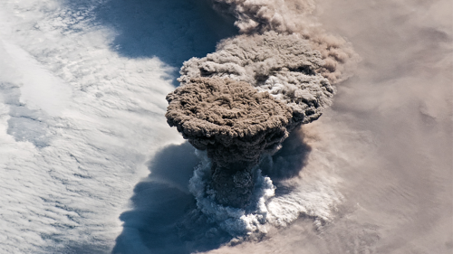
Unlike some of its perpetually active neighbors on the Kamchatka Peninsula, Raikoke Volcano on the Kuril Islands rarely erupts. The small, oval-shaped island most recently exploded in 1924 and in 1778.
The dormant period ended around 4:00 a.m. local time on June 22, 2019, when a vast plume of ash and volcanic gases shot up from its 700-meter-wide crater. Several satellites—as well as astronauts on the International Space Station—observed as a thick plume rose and then streamed east as it was pulled into the circulation of a storm in the North Pacific.
On the morning of June 22, astronauts shot this photograph of the volcanic plume rising in a narrow column and then spreading out in a part of the plume known as the umbrella region. That is the area where the density of the plume and the surrounding air equalize and the plume stops rising. The ring of clouds at the base of the column appears to be water vapor.
See all of the images and vote now HERE.
Make sure to follow us on Tumblr for your regular dose of space: http://nasa.tumblr.com.
Pluto the Small Dwarf Planet
Tired of singing the same holiday songs? Here’s a celestial take on the classic Rudolph the Red Nose Reindeer that you can introduce to your friends and family.

(Three infrared wavelength ranges were placed into the three color channels (red, green and blue, respectively) to create this false color Christmas portrait.)
Sung to the tune of Rudolph the Red Nosed Reindeer
Intro You know Mercury, Venus and Earth and Mars, too Jupiter, Saturn, Uranus, and Neptune But do you recall the most famous Solar System body of all
Verse 1 Pluto the small dwarf planet Has a very shiny glow And if you had discovered it Your name might be Clyde Tombaugh
Verse 2 All of the other planets used to laugh and call him names They never let poor Pluto join in planetary games
Verse 3 Then one fateful summer eve New Horizons came to say “Pluto with your heart so bright Won’t you let me flyby tonight?”
Verse 4 Then all the planets loved him and they shouted out with glee, “NASA!” Pluto the small dwarf planet You’ll go down in history!
(repeat V3 and V4)
This song was written by Andres Almeida, a NASA employee, for a holiday office party. It’s a fun take on the classic Rudolph the Red Nosed Reindeer, with a NASA spin. Enjoy!
Make sure to follow us on Tumblr for your regular dose of space: http://nasa.tumblr.com
What are CubeSats?
CubeSats are a class of research spacecraft called nanosatellites. They provide low-cost opportunities for small satellite payloads to fly on rockets planned for upcoming launches. Small satellites, including CubeSats, are playing an increasingly larger role in exploration, technology demonstration, scientific research and educational investigations here at NASA.

Fourteen miniature satellites were deployed from the International Space Station earlier this week. Two of the CubeSats were Danish and have communication and ship signal tracking capabilities. The remaining are Dove satellites from Planet Labs and will take images of Earth from space.
On Thursday, Oct. 8, thirteen CubeSats are scheduled to launch aboard a United Launch Alliance Atlas V rocket at 8:49 a.m. EDT. Watch live on NASA TV starting at 8:29 a.m. http://www.nasa.gov/nasatv
To learn more about tomorrow’s launch, watch NASA Television today, Oct. 7 at 1 p.m. and 2 p.m. EDT. The briefings will highlight the growing importance of CubeSats in space exploration.
Make sure to follow us on Tumblr for your regular dose of space: http://nasa.tumblr.com
@tinyscoop: What's the strangest experiment you've ever had to carry out up there?
We Just Took a Major Step Forward in our Moon Landing Program
As part of the Commercial Lunar Payload Services (CLPS) initiative, we’ve selected the first American companies that will deliver our science and technology payloads to the Moon.

Seen above from left to right are lander prototypes from:
Astrobotic of Pittsburgh, Pennsylvania
Intuitive Machines of Houston, Texas
Orbit Beyond of Edison, New Jersey

Astrobotic of Pittsburgh has proposed to fly as many as 14 payloads to a large crater on the near side of the Moon.

Intuitive Machines of Houston has proposed to fly as many as five payloads to a scientifically intriguing dark spot on the Moon.

Orbit Beyond of Edison, New Jersey, has proposed to fly as many as four payloads to a lava plain in one of the Moon’s craters.
Each company is charged with demonstrating technology that will shape the development of future landers and other exploration systems needed for humans to return to the Moon’s surface under the new Artemis program. Artemis is the program that will send the first woman and the next man to the Moon by 2024 and develop a sustainable human presence on the Moon by 2028. The program takes its name from the twin sister of Apollo and goddess of the Moon in Greek mythology.

Together we are going to the Moon—to stay.
Watch the CLPS announcement on our YouTube channel to learn about how each company will prepare us for human missions to the Moon: https://www.youtube.com/watch?v=qODDdqK9rL4
Make sure to follow us on Tumblr for your regular dose of space: http://nasa.tumblr.com.
-
 sweetrascalbasketballturkey-blog liked this · 5 years ago
 -
 myspacedeathposts-blog reblogged this · 7 years ago
 -
 satansbrunchbuddy liked this · 7 years ago
 -
 liviamarly liked this · 7 years ago
 -
 sweatypizzatimetravel reblogged this · 7 years ago
 -
 chelsology liked this · 7 years ago
 -
 blueackles liked this · 7 years ago
 -
 enabigfoot liked this · 7 years ago
 -
 deutsches-requiem reblogged this · 7 years ago
 -
 koukrisity reblogged this · 7 years ago
 -
 kkeiraknightley reblogged this · 7 years ago
 -
 apollosnote-blog liked this · 7 years ago
 -
 jchapa13 liked this · 7 years ago
 -
 mentaliongmai liked this · 7 years ago
 -
 us2626-blog liked this · 7 years ago
 -
 invisibleninjataco liked this · 7 years ago
 -
 busserdinda reblogged this · 7 years ago
 -
 dindabusser liked this · 7 years ago
 -
 babamjan liked this · 7 years ago
 -
 teaminvisible reblogged this · 7 years ago
 -
nakiyamesinsuke-blog liked this · 7 years ago
-
 magicaltear liked this · 7 years ago
 -
 purple-beans reblogged this · 7 years ago
 -
purple-beans liked this · 7 years ago
-
 thugmansion reblogged this · 7 years ago
 -
 that-little-witchy-bitch liked this · 7 years ago
 -
 kaaahn8 liked this · 7 years ago
 -
 radgivercrown liked this · 7 years ago
 -
 lunar-court liked this · 7 years ago
 -
 srandreia liked this · 7 years ago
 -
 iandallamba liked this · 7 years ago
 -
 avoanoikxd-blog liked this · 7 years ago
 -
 naturenestd-blog liked this · 7 years ago
Explore the universe and discover our home planet with the official NASA Tumblr account
1K posts