Solar System: 10 Things To Know
Solar System: 10 Things to Know
All About Ice
1. Earth's Changing Cryosphere

This year, we will launch two satellite missions that will increase our understanding of Earth's frozen reaches. Snow, ice sheets, glaciers, sea ice and permafrost, known as the cryosphere, act as Earth's thermostat and deep freeze, regulating temperatures by reflecting heat from the Sun and storing most of our fresh water.
2. GRACE-FO: Building on a Legacy and Forging Ahead

The next Earth science satellites set to launch are twins! The identical satellites of the GRACE Follow-On mission will build on the legacy of their predecessor GRACE by also tracking the ever-changing movement of water around our planet, including Earth's frozen regions. GRACE-FO, a partnership between us and the German Research Center for Geosciences (GFZ), will provide critical information about how the Greenland and Antarctic ice sheets are changing. GRACE-FO, working together, will measure the distance between the two satellites to within 1 micron (much less than the width of a human hair) to determine the mass below.

Greenland has been losing about 280 gigatons of ice per year on average, and Antarctica has lost almost 120 gigatons a year with indications that both melt rates are increasing. A single gigaton of water would fill about 400,000 Olympic-sized swimming pools; each gigaton represents a billion tons of water.
3. ICESat-2: 10,000 Laser Pulses a Second

In September, we will launch ICESat-2, which uses a laser instrument to precisely measure the changing elevation of ice around the world, allowing scientists to see whether ice sheets and glaciers are accumulating snow and ice or getting thinner over time. ICESat-2 will also make critical measurements of the thickness of sea ice from space. Its laser instrument sends 10,000 pulses per second to the surface and will measure the photons' return trip to satellite. The trip from ICESat-2 to Earth and back takes about 3.3 milliseconds.
4. Seeing Less Sea Ice

Summertime sea ice in the Arctic Ocean now routinely covers about 40% less area than it did in the late 1970s, when continuous satellite observations began. This kind of significant change could increase the rate of warming already in progress and affect global weather patterns.
5. The Snow We Drink

In the western United States, 1 in 6 people rely on snowpack for water. Our field campaigns such as the Airborne Snow Observatory and SnowEx seek to better understand how much water is held in Earth's snow cover, and how we could ultimately measure this comprehensively from space.
6. Hidden in the Ground

Permafrost - permanently frozen ground in the Arctic that contains stores of heat-trapping gases such as methane and carbon dioxide - is thawing at faster rates than previously observed. Recent studies suggest that within three to four decades, this thawing could be releasing enough greenhouse gases to make Arctic permafrost a net source of carbon dioxide rather than a sink. Through airborne and field research on missions such as CARVE and ABoVE - the latter of which will put scientists back in the field in Alaska and Canada this summer - our scientists are trying to improve measurements of this trend in order to better predict global impact.
7. Breaking Records Over Cracking Ice

Last year was a record-breaking one for Operation IceBridge, our aerial survey of polar ice. For the first time in its nine-year history, the mission carried out seven field campaigns in the Arctic and Antarctic in a single year. In total, the IceBridge scientists and instruments flew over 214,000 miles, the equivalent of orbiting the Earth 8.6 times at the equator.

On March 22, we completed the first IceBridge flight of its spring Arctic campaign with a survey of sea ice north of Greenland. This year marks the 10th Arctic spring campaign for IceBridge. The flights continue until April 27 extending the mission's decade-long mapping of the fastest-changing areas of the Greenland Ice Sheet and measuring sea ice thickness across the western Arctic basin.
8. OMG

Researchers were back in the field this month in Greenland with our Oceans Melting Greenland survey. The airborne and ship-based mission studies the ocean's role in melting Greenland's ice. Researchers examine temperatures, salinity and other properties of North Atlantic waters along the more than 27,000 miles (44,000 km) of jagged coastline.
9. DIY Glacier Modeling

Computer models are critical tools for understanding the future of a changing planet, including melting ice and rising seas. Our new sea level simulator lets you bury Alaska's Columbia glacier in snow, and, year by year, watch how it responds. Or you can melt the Greenland and Antarctic ice sheets and trace rising seas as they inundate the Florida coast.
10. Ice Beyond Earth

Ice is common in our solar system. From ice packed into comets that cruise the solar system to polar ice caps on Mars to Europa and Enceladus-the icy ocean moons of Jupiter and Saturn-water ice is a crucial ingredient in the search for life was we know it beyond Earth.
Read the full version of this week’s 10 Things to Know HERE.
Make sure to follow us on Tumblr for your regular dose of space: http://nasa.tumblr.com.
More Posts from Nasa and Others
Moon Mountain Named After Melba Roy Mouton, NASA Mathematician

Award-winning NASA mathematician and computer programmer Melba Mouton is being honored with the naming of a mountain at the Moon’s South Pole. Mouton joined NASA in 1959, just a year after the space agency was established. She was the leader of a team that coded computer programs to calculate spacecraft trajectories and locations. Her contributions were instrumental to landing the first humans on the Moon.
She also led the group of "human computers," who tracked the Echo satellites. Roy and her team's computations helped produce the orbital element timetables by which millions could view the satellite from Earth as it passed overhead.
The towering lunar landmark now known as “Mons Mouton” stands at a height greater than 19,000 feet. The mountain was created over billions of years by lunar impacts. Huge craters lie around its base—some with cliff-like edges that descend into areas of permanent darkness. Mons Mouton is the future landing site of VIPER, our first robotic Moon rover. The rover will explore the Moon’s surface to help gain a better understanding of the origin of lunar water. Here are things to know:
Mons Mouton is a wide, relatively flat-topped mountain that stretches roughly 2,700 square miles

The mountain is the highest spot at the Moon’s South Pole and can be seen from Earth with a telescope

Our VIPER Moon rover will explore Mons Mouton over the course of its 100-day mission

VIPER will map potential resources which will help inform future landing sites under our Artemis program

The VIPER mission is managed by our Ames Research Center in California’s Silicon Valley. The approximately 1,000-pound rover will be delivered to the Moon by a commercial vendor as part of our Commercial Lunar Payload Services initiative, delivering science and technology payloads to and near the Moon.
Make sure to follow us on Tumblr for your regular dose of space!
New Science from our Mission to Touch the Sun

In August 2018, our Parker Solar Probe mission launched to space, soon becoming the closest-ever spacecraft from the Sun. Now, scientists have announced their first discoveries from this exploration of our star!
The Sun may look calm to us here on Earth, but it's an active star, unleashing powerful bursts of light, deluges of particles moving near the speed of light and billion-ton clouds of magnetized material. All of this activity can affect our technology here on Earth and in space.
Parker Solar Probe's main science goals are to understand the physics that drive this activity — and its up-close look has given us a brand-new perspective. Here are a few highlights from what we've learned so far.
1. Surprising events in the solar wind
The Sun releases a continual outflow of magnetized material called the solar wind, which shapes space weather near Earth. Observed near Earth, the solar wind is a relatively uniform flow of plasma, with occasional turbulent tumbles. Closer to the solar wind's source, Parker Solar Probe saw a much different picture: a complicated, active system.
One type of event in particular drew the eye of the science teams: flips in the direction of the magnetic field, which flows out from the Sun, embedded in the solar wind. These reversals — dubbed "switchbacks" — last anywhere from a few seconds to several minutes as they flow over Parker Solar Probe. During a switchback, the magnetic field whips back on itself until it is pointed almost directly back at the Sun.

The exact source of the switchbacks isn't yet understood, but Parker Solar Probe's measurements have allowed scientists to narrow down the possibilities — and observations from the mission's 21 remaining solar flybys should help scientists better understand these events.
2. Seeing tiny particle events
The Sun can accelerate tiny electrons and ions into storms of energetic particles that rocket through the solar system at nearly the speed of light. These particles carry a lot of energy, so they can damage spacecraft electronics and even endanger astronauts, especially those in deep space, outside the protection of Earth's magnetic field — and the short warning time for such particles makes them difficult to avoid.

Energetic particles from the Sun impact a detector on ESA & NASA's SOHO satellite.
Parker Solar Probe's energetic particle instruments have measured several never-before-seen events so small that all trace of them is lost before they reach Earth. These instruments have also measured a rare type of particle burst with a particularly high number of heavier elements — suggesting that both types of events may be more common than scientists previously thought.
3. Rotation of the solar wind
Near Earth, we see the solar wind flowing almost straight out from the Sun in all directions. But the Sun rotates as it releases the solar wind, and before it breaks free, the wind spins along in sync with the Sun's surface. For the first time, Parker was able to observe the solar wind while it was still rotating – starting more than 20 million miles from the Sun.

The strength of the circulation was stronger than many scientists had predicted, but it also transitioned more quickly than predicted to an outward flow, which helps mask the effects of that fast rotation from the vantage point where we usually see them from, near Earth, about 93 million miles away. Understanding this transition point in the solar wind is key to helping us understand how the Sun sheds energy, with implications for the lifecycles of stars and the formation of protoplanetary disks.
4. Hints of a dust-free zone
Parker also saw the first direct evidence of dust starting to thin out near the Sun – an effect that has been theorized for nearly a century, but has been impossible to measure until now. Space is awash in dust, the cosmic crumbs of collisions that formed planets, asteroids, comets and other celestial bodies billions of years ago. Scientists have long suspected that, close to the Sun, this dust would be heated to high temperatures by powerful sunlight, turning it into a gas and creating a dust-free region around the Sun.

For the first time, Parker's imagers saw the cosmic dust begin to thin out a little over 7 million miles from the Sun. This decrease in dust continues steadily to the current limits of Parker Solar Probe's instruments, measurements at a little over 4 million miles from the Sun. At that rate of thinning, scientists expect to see a truly dust-free zone starting a little more than 2-3 million miles from the Sun — meaning the spacecraft could observe the dust-free zone as early as 2020, when its sixth flyby of the Sun will carry it closer to our star than ever before.
These are just a few of Parker Solar Probe's first discoveries, and there's plenty more science to come throughout the mission! For the latest on our Sun, follow @NASASun on Twitter and NASA Sun Science on Facebook.
6 Ways You Are Safer Thanks to NASA Technology
By now everyone knows that we are to thank for the memory foam in your mattress and the camera in your cell phone. (Right? Right.)
But our technology is often also involved behind the scenes—in ways that make the products we use daily safer and stronger, and in some cases, that can even save lives.
Here are some examples from this year’s edition of Spinoff, our yearly roundup of “space in your life”:
Impact Testing

What happens to your car bumper in an accident? When does it crumple and when does it crack? And are all bumpers coming off the assembly line created equal?
These types of questions are incredibly important when designing a safe car, and one technology that helps almost every U.S. automobile manufacturer find answers is something we helped develop when we had similar questions about the Space Shuttle.
Before flying again after the Columbia disaster in 2003, we had to be sure we understood what went wrong and how to prevent it from ever happening again. We worked with Trilion, Inc. to develop a system using high-speed cameras and software to analyze every impact—from the one that actually happened on the Shuttle to any others we could imagine—and design fixes.
Finding Survivors

We’re pretty good at finding things you can’t see with the naked eye—from distant exoplanets to water on Mars.
But there are also plenty of uses for that know-how on Earth.
One example that has already saved lives: locating heartbeats under debris.
Engineers at our Jet Propulsion Laboratory adapted technology first devised to look for gravity fluctuations to create FINDER, which stands for Finding Individuals for Disaster and Emergency Response and can detect survivors through dense rubble.
We have licensed the technology to two companies, including R4, and it has already been used in natural disaster responses, including after earthquakes in Nepal, Mexico City, Ecuador, and after Hurricane Maria in Puerto Rico.
Fighting Forest Fires

As we have seen this year with devastating wildfires in California, forest fires can spread incredibly quickly.
Knowing when to order an evacuation, where to send firefighters, and how to make every other decision—all amid a raging inferno—depends on having the most up-to-date information as quickly as possible.
Using our expertise in remote sensing and communicating from space, we helped the U.S. Forest Service make its process faster and more reliable, so the data from airborne sensors gets to decision makers on the front line and at the command center in the blink of an eye.
Safer, Germ-Free Ambulances

When paramedics come racing into a home, the last thing anybody is worrying about is where the ambulance was earlier that morning. A device we helped create ensures you won’t have to.
AMBUstat creates a fog that sterilizes every surface in an ambulance in minutes, so any bacteria, viruses or other contaminants won’t linger on to infect the next patient.
This technology works its magic through the power of atomic oxygen—the unpaired oxygen atoms that are common in the upper reaches of Earth’s atmosphere. We’ve had to learn about these atoms to devise ways to ensure they won’t destroy our spacecraft or harm astronauts, but here, we were able to use that knowledge to direct that destructive power at germs.
Air Filters

Did you know the air we breathe inside buildings is often up to 10 times more polluted than the air outdoors?
Put the air under a microscope and it’s not pretty, but a discovery we made in the 1990s can make a big impact.
We were working on a way to clear a harmful chemical that accumulates around plants growing on a spacecraft, and it turned out to also neutralize bacteria, viruses, and mold and eliminate volatile organic compounds.
Now air purifiers using this technology are deployed in hospital operating rooms, restaurant kitchens, and even major baseball stadiums to improve air quality and keep everyone healthier. Oh, and you can buy one for your house, too.
Driverless Cars

Car companies are moving full-speed ahead to build the driverless cars of the not-so-distant future. Software first created to help self-learning robots navigate on Mars may help keep passengers and pedestrians safer once those cars hit the road. The software creates an artificially intelligent “brain” for a car (or drone, for that matter) that can automatically identify and differentiate between cars, trucks, pedestrians, cyclists, and more, helping ensure the car doesn’t endanger any of them.
So, now that you know a few of the spinoff technologies that we helped develop, you can look for them throughout your day. Visit our page to learn about more spinoff technologies: https://spinoff.nasa.gov Make sure to follow us on Tumblr for your regular dose of space: http://nasa.tumblr.com.
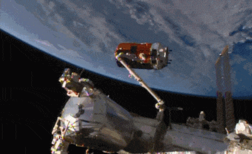
Aboard the International Space Station this morning, Astronaut Kimiya Yui of the Japan Aerospace Exploration Agency (JAXA) successfully captured JAXA's Kounotori 5 H-II Transfer Vehicle (HTV-5) at 6:28 a.m. EDT.
Yui commanded the station's robotic arm, Canadarm2, to reach out and grapple the HTV-5, while NASA astronauts Kjell Lindgren provided assistance and Scott Kelly monitored HTV-5 systems. The HTV-5 launched aboard an H-IIB rocket at 7:50 a.m. Wednesday, Aug. 19, from the Tanegashima Space Center in southern Japan. Since then, the spacecraft has performed a series of engine burns to fine-tune its course for arrival at the station.
The HTV-5 is delivering more than 8,000 pounds of equipment, supplies and experiments in a pressurized cargo compartment. The unpressurized compartment will deliver the 1,400-pound CALorimetric Electron Telescope (CALET) investigation, an astrophysics mission that will search for signatures of dark matter and provide the highest energy direct measurements of the cosmic ray electron spectrum.
Below is a breathtaking image shared by Astronaut Scott Kelly of the HTV-5 and Canadarm2, which reached out and grappled the cargo spacecraft.

Which Landsat Image Do You Love?
Feeling competitive? We’ve got a game for you to play in! Tournament Earth: The Landsat Games is happening right now, and as we get to the final entries, the competition is heating up.

You can help us pick the winner by voting for one of the remaining four Landsat images of our home planet! Our competition started with 32 images, divided into categories by what they show: land, water, ice & snow, and human impact.
So, what do you think? Which one of these images is going for gold?
Land
First up, we have an image of the Markha River and surrounding Central Siberian Plateau, acquired in 2020 by Landsat 8. The hypnotic undulations of striping across the landscape carried this image to victory over the rest of the Land images -- a particularly tough category, given that these images all come from Landsat.

Water
It’s not all land, though! The bright blues and greens of this false-color image of the Atchafalaya Delta in Louisiana helped carry it to victory in the Water category. The image, taken in 2020 by Landsat 8, shows a region that’s subject to erosion of land by wind and rising sea levels.

Ice & Snow
Brrr! Did it get cold in here? That’s the finalist from the Ice and Snow category, an image of sea ice around Russia’s New Siberian Islands. The image, collected by Landsat 8 in June 2016, shows sea ice during its annual seasonal breakup.

Human Impact
Humans have been shaping the planet around us for hundreds of years. Some changes, like rice fields in the Sacramento Valley, are visible from space. Landsat 8 collected this false-color image of flooded rice fields in December 2018.

So, now it’s up to you! Which image is your favorite? There can only be one winner of Tournament Earth: The Landsat Games. Get your vote in, and then get ready to watch as we launch the next Landsat satellite, Landsat 9, in September.

The Landsat mission is a partnership between us at NASA and the U.S. Geological Survey. Together, we’ve been using Landsat satellites to collect nearly 50 years of images of our home planet.
Make sure to follow us on Tumblr for your regular dose of space.
Solar System: 10 Things to Know This Week
Need some space?
Here are 10 perspective-building images for your computer desktop and mobile device wallpaper.
These are all real images, sent very recently by our planetary missions throughout the solar system.
1. Our Sun

Warm up with this view from our Solar Dynamics Observatory showing active regions on the Sun in October 2017. They were observed in a wavelength of extreme ultraviolet light that reveals plasma heated to over a million degrees.
Downloads Desktop: 1280 x 800 | 1600 x 1200 | 1920 x 1200 Mobile: 1440 x 2560 | 1080 x 1920 | 750 x 1334
2. Jupiter Up-Close

This series of enhanced-color images shows Jupiter up close and personal, as our Juno spacecraft performed its eighth flyby of the gas giant planet on Sept. 1, 2017.
Downloads Desktop: 1280 x 800 | 1600 x 1200 | 1920 x 1200 Mobile: 1440 x 2560 | 1080 x 1920 | 750 x 1334
3. Saturn’s and Its Rings

With this mosaic from Oct. 28, 2016, our Cassini spacecraft captured one of its last looks at Saturn and its main rings from a distance.
Downloads Desktop: 1280 x 800 | 1600 x 1200 | 1920 x 1200 Mobile: 1440 x 2560 | 1080 x 1920 | 750 x 1334
4. Gale Crater on Mars

This look from our Curiosity Mars rover includes several geological layers in Gale crater to be examined by the mission, as well as the higher reaches of Mount Sharp beyond. The redder rocks of the foreground are part of the Murray formation. Pale gray rocks in the middle distance of the right half of the image are in the Clay Unit. A band between those terrains is "Vera Rubin Ridge," where the rover is working currently. The view combines six images taken with the rover's Mast Camera (Mastcam) on Jan. 24, 2017.
Downloads Desktop: 1280 x 800 | 1600 x 1200 | 1920 x 1200 Mobile: 1440 x 2560 | 1080 x 1920 | 750 x 1334
5. Sliver of Saturn

Cassini peers toward a sliver of Saturn's sunlit atmosphere while the icy rings stretch across the foreground as a dark band on March 31, 2017. This view looks toward the unilluminated side of the rings from about 7 degrees below the ring plane.
Downloads Desktop: 1280 x 800 | 1600 x 1200 | 1920 x 1200 Mobile: 1440 x 2560 | 1080 x 1920 | 750 x 1334
6. Dwarf Planet Ceres

This image of the limb of dwarf planet Ceres shows a section of the northern hemisphere, as seen by our Dawn mission. Prominently featured is Occator Crater, home of Ceres' intriguing "bright spots." The latest research suggests that the bright material in this crater is comprised of salts left behind after a briny liquid emerged from below.
Downloads Desktop: 1280 x 800 | 1600 x 1200 | 1920 x 1200 Mobile: 1440 x 2560 | 1080 x 1920 | 750 x 1334
7. Martian Crater

This image from our Mars Reconnaissance Orbiter (MRO) shows a crater in the region with the most impressive known gully activity in Mars' northern hemisphere. Gullies are active in the winter due to carbon dioxide frost, but northern winters are shorter and warmer than southern winters, so there is less frost and less gully activity.
Downloads Desktop: 1280 x 800 | 1600 x 1200 | 1920 x 1200 Mobile: 1440 x 2560 | 1080 x 1920 | 750 x 1334
8. Dynamic Storm on Jupiter

A dynamic storm at the southern edge of Jupiter's northern polar region dominates this Jovian cloudscape, courtesy of Juno. This storm is a long-lived anticyclonic oval named North North Temperate Little Red Spot 1. Citizen scientists Gerald Eichstädt and Seán Doran processed this image using data from the JunoCam imager.
Downloads Desktop: 1280 x 800 | 1600 x 1200 | 1920 x 1200 Mobile: 1440 x 2560 | 1080 x 1920 | 750 x 1334
9. Rings Beyond Saturn’s Sunlit Horizon

This false-color view from the Cassini spacecraft gazes toward the rings beyond Saturn's sunlit horizon. Along the limb (the planet's edge) at left can be seen a thin, detached haze.
Downloads Desktop: 1280 x 800 | 1600 x 1200 | 1920 x 1200 Mobile: 1440 x 2560 | 1080 x 1920 | 750 x 1334
10. Saturn’s Ocean-Bearing Moon Enceladus

Saturn's active, ocean-bearing moon Enceladus sinks behind the giant planet in a farewell portrait from Cassini. This view of Enceladus was taken by NASA's Cassini spacecraft on Sept. 13, 2017. It is among the last images Cassini sent back before its mission came to an end on Sept. 15, after nearly 20 years in space.
Downloads Desktop: 1280 x 800 | 1600 x 1200 | 1920 x 1200 Mobile: 1440 x 2560 | 1080 x 1920 | 750 x 1334
Applying Wallpaper: 1. Click on the screen resolution you would like to use. 2. Right-click on the image (control-click on a Mac) and select the option 'Set the Background' or 'Set as Wallpaper' (or similar).
Places to look for more of our pictures include solarsystem.nasa.gov/galleries, images.nasa.gov and www.jpl.nasa.gov/spaceimages.
Make sure to follow us on Tumblr for your regular dose of space: http://nasa.tumblr.com
Small Businesses Help Us Explore Space!
Earlier this month, Congress introduced a resolution officially recognizing Nov. 24, 2018 as Small Business Saturday “to increase awareness of the value of locally owned small businesses and the impact of locally owned small businesses on the economy of the United States.”
This annual American Express campaign began on the Saturday after Thanksgiving in 2010 to support “local places that make our communities strong.”

For 60 years, we have supported and partnered with small businesses across the country to pioneer the future of space exploration, scientific discovery and aeronautics research.
Our Small Business Innovative Research (SBIR) and Small Business Technology Transfer (STTR) program funds the research, development and demonstration of innovative technologies that help address space exploration challenges and have significant potential for commercialization. In 2018, our program awarded 555 contracts to small businesses for a total of $180.1 million.

NASA works with small business Nanocomp Technologies Inc. of Merrimack, New Hampshire, to advance manufacturing of carbon nanotube composite materials.
Our investments in small businesses help equip future missions to the Moon, Mars and beyond by advancing our science and technology capabilities. They also benefit the U.S. economy. The SBIR/STTR program’s 2017 Economic Impact Report indicated a $2.74 return for every dollar spent on awards—money well spent!
Small businesses also contribute to scientific advances for the International Space Station as well as here on Earth. Pancopia, Inc. in Hampton, Virginia, developed an innovative, high-performance water recycling system to remove high levels of organic carbon and nitrogen in wastewater. Recycling water in space saves money on resupply and enables more Earth-independence and self-reliance. With the help of an SBIR award, Pancopia is also working on a similar system for public wastewater that has the potential to cut treatment expenses to less than half the current costs.

Small businesses also contribute to scientific advances for the International Space Station as well as here on Earth. Pancopia, Inc. in Hampton, Virginia, developed an innovative, high-performance water recycling system to remove high levels of organic carbon and nitrogen in wastewater. Recycling water in space saves money on resupply and enables more Earth-independence and self-reliance. With the help of an SBIR award, Pancopia is also working on a similar system for public wastewater that has the potential to cut treatment expenses to less than half the current costs.

When NASA went to the private sector to develop deformable mirror technology—a key component of starlight-blocking instruments—a small business in Berkeley, California, applied for research and development funding through SBIR to design extra-precision, segmented mirrors. This innovative approach for a small deformable mirror made up of many tiny hexagonal segments enables advanced control when paired with other optics.

Data collected by a telescope using the Iris AO deformable mirror can be used to determine if the target investigated in space is an exoplanet based on its orbit, and if the exoplanet has atmosphere using color spectrum imaging analysis. The Iris AO technology is currently being refined and prepared for inclusion in a future exoplanet mission.
Does your small business have a big idea? Your next opportunity to join our SBIR/STTR program starts on Jan. 7, 2019, when our next solicitation opens. We’ll be seeking new innovative ideas from small businesses and research institutions for research, development and demonstration of innovative technologies. Go to https://www.nasa.sbir.gov/ to learn more.
Make sure to follow us on Tumblr for your regular dose of space: http://nasa.tumblr.com
Other than joy, why do you do the things you do?
Send Your Name to Jupiter
You’re invited to sign your name to a poem written by the U.S. Poet Laureate, Ada Limón. The poem connects two water worlds — Earth, yearning to reach out and understand what makes a world habitable, and Europa, waiting with secrets yet to be explored.
The poem will be engraved on Europa Clipper, along with participants' names that will be physically etched onto microchips mounted on the spacecraft. Together, the poem and names will travel 1.8 billion miles to the Jupiter system.

Signing up is easy! Just go to this site to sign your name to the poem and get on board. We also have a Spanish-language site where you can send your name en español: Envía tu nombre aquí.
The Europa Clipper launch window opens in October 2024, but don’t wait – everyone’s names need to be received by December 31 this year so they can be loaded onto the spacecraft in time. We hope you’ll be riding along with us! Follow the mission at europa.nasa.gov.
Make sure to follow us on Tumblr for your regular dose of space!
Pioneering with Perseverance: More Technology Firsts
From launching the largest, heaviest, most sophisticated vehicle we have ever sent to Mars, to its elegant landing at Jezero Crater – a treacherous yet promising location for finding signs of ancient life – the journey of our Perseverance rover has already been and continues to be a bold one.

But let’s not forget, building new tools and instruments or designing ways to study other worlds is not easy. Before engineers even dreamt of sending their hardware for a spin on Mars, they spent years doing all they could to validate tech on Earth – modeling in labs, flying experiments on suborbital rockets or high-altitude balloons, or testing in various facilities to simulate the harsh conditions of space.

We know that technology demonstrations – that test a new capability in space – can be risky, but trying new things is how we forge ahead, learn for future missions, and reach new heights in space.
Perseverance has already accomplished some amazing “firsts” but there are more to come. Here are four more trailblazing technologies on the Mars 2020 mission.
1. First Powered Flight on Another World
This week, the Ingenuity Mars Helicopter, a small, autonomous rotorcraft originally stowed beneath the rover, will make the first-ever attempt at powered, controlled flight of an aircraft on another planet.
In the last few weeks, Ingenuity safely deployed from Perseverance, charged up its solar panel, survived its first bone-chilling Martian night and firmly planted four legs on the ground. Once the team on Earth confirms that the rover drove about 16 feet (about 5 meters) away, and that both helicopter and rover are communicating via their onboard radios, preflight checks will begin, and Ingenuity will be on its way skyward.

Perseverance will receive and relay the final flight instructions from mission controllers at our Jet Propulsion Laboratory to Ingenuity. Ingenuity will run its rotors to 2,537 rpm and, if all final self-checks look good, lift off. After climbing at a rate of about 3 feet per second (1 meter per second), the helicopter will hover at 10 feet (3 meters) above the surface for up to 30 seconds. Then, the Mars Helicopter will descend and touch back down on the Martian surface. With a smooth landing and continued operability, up to four more flights could be attempted, each one building on the success of the last.
Ingenuity could pave the way for other advanced robotic flying vehicles. Possible uses of next-generation rotorcraft on Mars include:
A unique viewpoint not provided by current orbiters, rovers or landers
High-definition images and reconnaissance for robots or humans
Access to terrain that is difficult for rovers to reach
Could even carry light but vital payloads from one site to another
Here’s how to follow along as this flight makes history.
2. First Production of Oxygen from Martian Atmosphere
The Mars Oxygen In-Situ Resource Utilization Experiment, better known as MOXIE, is preparing us for human exploration of Mars by demonstrating a way to extract oxygen directly from the Martian atmosphere. That could mean access to air for breathing, but also the ability to produce vast quantities of rocket fuel to return astronauts to Earth.

Located inside the body of Perseverance, the car battery-sized instrument works like a miniature electronic tree on the rover, inhaling carbon dioxide, separating the molecule, and exhaling carbon monoxide and oxygen.

MOXIE is the first demonstration of its kind on another planet – the first test of an in-situ resource utilization technology, meaning it generates a usable product from local materials. The farther humans go into deep space, the more important this will be, due to the limited immediate access to supplies.
MOXIE will give a go at its first operations soon, a huge first step in proving it’s feasible to make oxygen, in situ, on Mars. Future, larger versions of MOXIE (something about the size of a washing machine) could produce oxygen 200 times faster by operating continuously.
3. First Weather Reporter at Jezero Crater
The Mars Environmental Dynamics Analyzer (MEDA) system makes weather measurements including wind speed and direction, temperature and humidity, and also measures the amount and size of dust particles in the Martian atmosphere.
Using MEDA data, engineers on Earth recently pieced together the first weather report from Jezero Crater. Measurements from MEDA sensors are even helping to determine the optimal time for Ingenuity’s first flight.

The weather instrument aboard the Curiosity rover – currently located a good 2,300 miles away from Perseverance on Mars – provides similar daily weather and atmospheric data. But MEDA can record the temperature at three atmospheric heights in addition to the surface temperature. It also records the radiation budget near the surface, which will help prepare for future human exploration missions on Mars.
MEDA’s weather reports, coupled with data gathered by Curiosity and NASA’s Insight lander, will enable a deeper understanding of Martian weather patterns, events, and atmospheric turbulence that could influence planning for future endeavors like the landing or launch of the proposed Mars Sample Return mission.
4. First Radar Tool to Probe Under the Martian Surface
On Earth, scientists use radar to look for things under the ground. They use it to study Mars-like glacial regions in the Arctic and Antarctic. Ground-penetrating radar helps us locate land mines; spot underground cables, wires, and pipes; or reveal ancient human artifacts and even buried treasure! On Mars, the "buried treasure" may be ice, which helps scientists understand the possibilities for Martian life and also identifies natural resources for future human explorers.
Perseverance's Radar Imager for Mars' Subsurface Experiment (RIMFAX) uses radar waves to probe the ground and reveal the unexplored world that lies beneath the Martian surface.

It’s the first ground-penetrating radar on the surface of Mars. RIMFAX will provide a highly detailed view of subsurface structures down to at least 30 feet (10 meters). With those measurements, the instrument will reveal hidden layers of geology and help find clues to past environments on Mars, especially those with conditions necessary for supporting life.
Stay tuned in to the latest Perseverance updates on the mission website and follow NASA Technology on Twitter and Facebook.
Make sure to follow us on Tumblr for your regular dose of space: http://nasa.tumblr.com
-
 purple-swanqueen98 liked this · 4 months ago
 -
 unmasdegagood liked this · 1 year ago
 -
 onkabano liked this · 1 year ago
 -
 lotlod reblogged this · 3 years ago
 -
lotlod liked this · 3 years ago
-
 syrupy-mushroom liked this · 3 years ago
 -
 alexanderboleyn18 liked this · 4 years ago
 -
 scrumptioushairdoghostoperator liked this · 4 years ago
 -
 tapiwamugabe liked this · 4 years ago
 -
 bodhishadow reblogged this · 4 years ago
 -
 masudranablog liked this · 4 years ago
 -
 kidzastri-hein liked this · 4 years ago
 -
 mystarryeyesareblinding liked this · 4 years ago
 -
 acalarakta liked this · 4 years ago
 -
 plotinuslovemachine liked this · 4 years ago
 -
 omnicogni liked this · 4 years ago
 -
 drawingwizardapprentice reblogged this · 4 years ago
 -
 lightmatters liked this · 4 years ago
 -
 lostrosegarden liked this · 4 years ago
 -
 anoukkino reblogged this · 4 years ago
 -
 wheniwishingreen liked this · 4 years ago
 -
 mwebazamaliza liked this · 4 years ago
 -
 sam260285-blog liked this · 4 years ago
 -
 tomorrowillbeyou liked this · 5 years ago
 -
 shiggyflip liked this · 5 years ago
 -
 dimens1ons liked this · 5 years ago
Explore the universe and discover our home planet with the official NASA Tumblr account
1K posts