What Space Weather Means For You
What Space Weather Means for You
In space, invisible, fast-moving particles from the Sun and other sources in deep space zip around, their behavior shaped by dynamic electric and magnetic fields. There are so few of these particles that space is considered a vacuum, but what’s there packs a punch. Together, we call all of this invisible activity space weather — and it affects our technology both in space and here on Earth.

This month, two new missions are launching to explore two different kinds of space weather.
Scrambled signals
Many of our communications and navigation systems — like GPS and radio — rely on satellites to transmit their signals. When signals are sent from satellites down to Earth, they pass through a dynamic zone on the upper edge of Earth's atmosphere called the ionosphere.

Gases in the ionosphere have been cooked into a sea of positive- and negative-charged particles by solar radiation. These electrically charged particles are also mixed in with neutral gases, like the air we breathe. The charged particles respond to electric and magnetic fields, meaning they react to space weather. Regular weather can also affect this part of the atmosphere.

Influenced by this complicated web of factors, structured bubbles of charged gas sometimes form in this part of the atmosphere, particularly near the equator. When signals pass through these bubbles, they can get distorted, causing failed communications or inaccurate GPS fixes.
Right now, it's hard to predict just when these bubbles will form or how they'll mess with signals. The two tiny satellites of the E-TBEx mission will try to shed some light on this question.

As these CubeSats fly around Earth, they'll send radio signals to receiving stations on the ground. Scientists will examine the signals received in order to see whether — and if so, how much — they were jumbled as they traveled through the upper atmosphere and down to Earth.
All together, this information will give scientists a better idea of how these bubbles form and change and how much they disrupt signals — information that could help develop strategies for mitigating these bubbles' disruptive effects.
Damaged satellites
The high-energy, fast-moving particles that fill space are called radiation. Every single spacecraft — from scientific satellites sprinkled throughout the solar system to the communications satellites responsible for relaying the GPS signals we use every day — must weather the harsh radiation of space.

Strikes from tiny, charged particles can spark memory damage or computer upsets on spacecraft, and over time, degrade hardware. The effects are wide-ranging, but ultimately, radiation can impact important scientific data, or prevent people from getting the proper navigation signals they need.
Space Environment Testbeds — or SET, for short — is our mission to study how to better protect satellites from space radiation.

SET aims its sights on a particular neighborhood of near-Earth space called the slot region: the gap between two of Earth’s vast, doughnut-shaped radiation belts, also known as the Van Allen Belts. The slot region is thought to be calmer than the belts, but known to vary during extreme space weather storms driven by the Sun. How much it changes exactly, and how quickly, remains uncertain.
The slot region is an attractive one for satellites — especially commercial navigation and communications satellites that we use every day — because from about 12,000 miles up, it offers not only a relatively friendly radiation environment, but also a wide view of Earth. During intense magnetic storms, however, energetic particles from the outer belt can surge into the slot region.

SET will survey the slot region, providing some of the first day-to-day weather measurements of this particular neighborhood in near-Earth space. The mission also studies the fine details of how radiation damages instruments and tests different methods to protect them, helping engineers build parts better suited for spaceflight. Ultimately, SET will help other missions improve their design, engineering and operations to avoid future problems, keeping our space technology running smoothly as possible.
For more on our space weather research, follow @NASASun on Twitter and NASA Sun Science on Facebook.
Meet the other NASA missions launching on the Department of Defense's STP-2 mission and get the latest updates at nasa.gov/spacex.
Make sure to follow us on Tumblr for your regular dose of space: http://nasa.tumblr.com.
More Posts from Nasa and Others
Distance: Hazard Far From Home
A human journey to Mars, at first glance, offers an inexhaustible amount of complexities. To bring a mission to the Red Planet from fiction to fact, our Human Research Program has organized some of the hazards astronauts will encounter on a continual basis into five classifications.

The third and perhaps most apparent hazard is, quite simply, the distance.


Rather than a three-day lunar trip, astronauts would be leaving our planet for roughly three years. Facing a communication delay of up to 20 minutes one way and the possibility of equipment failures or a medical emergency, astronauts must be capable of confronting an array of situations without support from their fellow team on Earth.

Once you burn your engines for Mars, there is no turning back so planning and self-sufficiency are essential keys to a successful Martian mission. The Human Research Program is studying and improving food formulation, processing, packaging and preservation systems.


While International Space Station expeditions serve as a rough foundation for the expected impact on planning logistics for such a trip, the data isn’t always comparable, but it is a key to the solution.

Exploration to the Moon and Mars will expose astronauts to five known hazards of spaceflight, including distance from Earth. To learn more, and find out what our Human Research Program is doing to protect humans in space, check out the "Hazards of Human Spaceflight" website. Or, check out this week’s episode of “Houston We Have a Podcast,” in which host Gary Jordan further dives into the threat of distance with Erik Antonsen, the Assistant Director for Human Systems Risk Management at the Johnson Space Center.

Make sure to follow us on Tumblr for your regular dose of space: http://nasa.tumblr.com.

Check out tiny-house-looking satellite Sentinel-6 Michael Freilich
It might look like something you’d find on Earth, but this piece of technology has a serious job to do: track global sea level rise with unprecedented accuracy. It’s #SeeingTheSeas mission will:
Provide information that will help researchers understand how climate change is reshaping Earth's coastlines – and how fast this is happenin.
Help researchers better understand how Earth's climate is changing by expanding the global atmospheric temperature data record
Help to improve weather forecasts by providing meteorologists information on atmospheric temperature and humidity.
Tune in tomorrow, Nov. 21 at 11:45 a.m. EST to watch this U.S.-European satellite launch to space! Liftoff is targeted for 12:17 p.m. EST. Watch HERE.
Make sure to follow us on Tumblr for your regular dose of space: http://nasa.tumblr.com.
What’s Up for September 2016

We won’t have a solar eclipse until Aug. 21, 2017, but observers in central Africa will see an annular eclipse, where the moon covers most but not all of the sun, on Sept. 1. Observers always need to use safe solar eclipse glasses or filters on telescopes, binoculars and cameras.

Also this month, there are two minor meteor showers, both with about 5 swift and bright meteors per hour at their peak, which will be near dawn. The first is the Aurigid shower on Sept. 1. The new moon on the first means the sky will be nice and dark for the Aurigids.

The second shower is the Epsilon Perseids on Sept. 9. The first quarter moon sets on the 9th at midnight, just in time for the best viewing of the Perseids.

There are many nice pair-ups between the moon and planets this month. You can see the moon between Venus and Jupiter on Sept. 2, and above Venus on the 3rd, right after sunset low on the West-Southwest horizon. On the 15th the nearly full moon pairs up with Neptune, two weeks after its opposition, when the 8th planet is closest to Earth in its orbit around the sun.
Watch the full September “What’s Up” video for more:
Make sure to follow us on Tumblr for your regular dose of space: http://nasa.tumblr.com.

Sharpening Our View of Climate Change with the Plankton, Aerosol, Cloud, ocean Ecosystem Satellite
As our planet warms, Earth’s ocean and atmosphere are changing.
Climate change has a lot of impact on the ocean, from sea level rise to marine heat waves to a loss of biodiversity. Meanwhile, greenhouse gases like carbon dioxide continue to warm our atmosphere.
NASA’s upcoming satellite, PACE, is soon to be on the case!
Set to launch on Feb. 6, 2024, the Plankton, Aerosol, Cloud, ocean Ecosystem (PACE) mission will help us better understand the complex systems driving the global changes that come with a warming climate.

Earth’s ocean is becoming greener due to climate change. PACE will see the ocean in more hues than ever before.
While a single phytoplankton typically can’t be seen with the naked eye, communities of trillions of phytoplankton, called blooms, can be seen from space. Blooms often take on a greenish tinge due to the pigments that phytoplankton (similar to plants on land) use to make energy through photosynthesis.
In a 2023 study, scientists found that portions of the ocean had turned greener because there were more chlorophyll-carrying phytoplankton. PACE has a hyperspectral sensor, the Ocean Color Instrument (OCI), that will be able to discern subtle shifts in hue. This will allow scientists to monitor changes in phytoplankton communities and ocean health overall due to climate change.

Phytoplankton play a key role in helping the ocean absorb carbon from the atmosphere. PACE will identify different phytoplankton species from space.
With PACE, scientists will be able to tell what phytoplankton communities are present – from space! Before, this could only be done by analyzing a sample of seawater.
Telling “who’s who” in a phytoplankton bloom is key because different phytoplankton play vastly different roles in aquatic ecosystems. They can fuel the food chain and draw down carbon dioxide from the atmosphere to photosynthesize. Some phytoplankton populations capture carbon as they die and sink to the deep ocean; others release the gas back into the atmosphere as they decay near the surface.
Studying these teeny tiny critters from space will help scientists learn how and where phytoplankton are affected by climate change, and how changes in these communities may affect other creatures and ocean ecosystems.

Climate models are one of our most powerful tools to understand how Earth is changing. PACE data will improve the data these models rely on.
The PACE mission will offer important insights on airborne particles of sea salt, smoke, human-made pollutants, and dust – collectively called aerosols – by observing how they interact with light.
With two instruments called polarimeters, SPEXone and HARP2, PACE will allow scientists to measure the size, composition, and abundance of these microscopic particles in our atmosphere. This information is crucial to figuring out how climate and air quality are changing.
PACE data will help scientists answer key climate questions, like how aerosols affect cloud formation or how ice clouds and liquid clouds differ.
It will also enable scientists to examine one of the trickiest components of climate change to model: how clouds and aerosols interact. Once PACE is operational, scientists can replace the estimates currently used to fill data gaps in climate models with measurements from the new satellite.

With a view of the whole planet every two days, PACE will track both microscopic organisms in the ocean and microscopic particles in the atmosphere. PACE’s unique view will help us learn more about the ways climate change is impacting our planet’s ocean and atmosphere.
Stay up to date on the NASA PACE blog, and make sure to follow us on Tumblr for your regular dose of sPACE!
Our Roman Space Telescope’s Dish is Complete!

NASA engineers recently completed tests of the high-gain antenna for our Nancy Grace Roman Space Telescope. This observatory has some truly stellar plans once it launches by May 2027. Roman will help unravel the secrets of dark energy and dark matter – two invisible components that helped shape our universe and may determine its ultimate fate. The mission will also search for and image planets outside our solar system and explore all kinds of other cosmic topics.
However, it wouldn’t be able to send any of the data it will gather back to Earth without its antenna. Pictured above in a test chamber, this dish will provide the primary communication link between the Roman spacecraft and the ground. It will downlink the highest data volume of any NASA astrophysics mission so far.

The antenna reflector is made of a carbon composite material that weighs very little but will still withstand wide temperature fluctuations. It’s very hot and cold in space – Roman will experience a temperature range of minus 26 to 284 degrees Fahrenheit (minus 32 to 140 degrees Celsius)!
The dish spans 5.6 feet (1.7 meters) in diameter, standing about as tall as a refrigerator, yet only weighs 24 pounds (10.9 kilograms) – about as much as a dachshund. Its large size will help Roman send radio signals across a million miles of intervening space to Earth.
At one frequency, the dual-band antenna will receive commands and send back information about the spacecraft’s health and location. It will use another frequency to transmit a flood of data at up to 500 megabits per second to ground stations on Earth. The dish is designed to point extremely accurately at Earth, all while both Earth and the spacecraft are moving through space.

Engineers tested the antenna to make sure it will withstand the spacecraft’s launch and operate as expected in the extreme environment of space. The team also measured the antenna’s performance in a radio-frequency anechoic test chamber. Every surface in the test chamber is covered in pyramidal foam pieces that minimize interfering reflections during testing. Next, the team will attach the antenna to the articulating boom assembly, and then electrically integrate it with Roman’s Radio Frequency Communications System.
Learn more about the exciting science this mission will investigate on Twitter and Facebook.
Make sure to follow us on Tumblr for your regular dose of space!
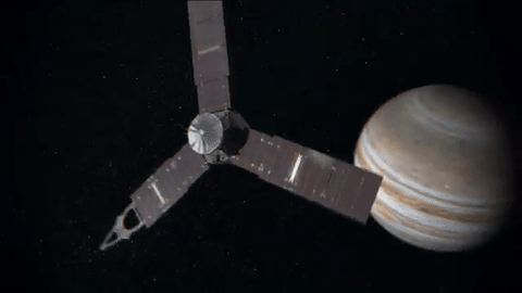
Let Us See Jupiter Through Your Eyes

Our Juno spacecraft will fly over Jupiter’s Great Red Spot on July 10 at 10:06 p.m. EDT. This will be humanity’s first up-close and personal view of the gas giant’s iconic 10,000-mile-wide storm, which has been monitored since 1830 and possibly existing for more than 350 years.

The data collection of the Great Red Spot is part of Juno’s sixth science flyby over Jupiter’s mysterious cloud tops. Perijove (the point at which an orbit comes closest to Jupiter’s center) will be July 10 at 9:55 p.m. EDT.

At the time of perijove, Juno will be about 2,200 miles above the planet’s cloud tops. Eleven minutes and 33 seconds later…Juno will have covered another 24,713 miles and will be directly above the coiling crimson cloud tops of the Great Red Spot. The spacecraft will pass about 5,600 miles above its clouds.
When will we see images from this flyby?
During the flyby, all eight of the spacecraft’s instruments will be turned on, as well as its imager, JunoCam. Because the spacecraft will be collecting data with its Microwave Radiometer (MWR), which measures radio waves from Jupiter’s deep atmosphere, we cannot downlink information during the pass. The MWR can tell us how much water there is and how material is moving far below the cloud tops.
During the pass, all data will be stored on-board…with a downlink planned afterwards. Once the downlink begins, engineering data from the spacecraft’s instruments will come to Earth first, followed by images from JunoCam.
The unprocessed, raw images will be located HERE, on approximately July 14. Follow @NASAJuno on Twitter for updates.
Did you know you can download and process these raw images?
We invite the public to act as a virtual imaging team…participating in key steps of the process, from identifying features of interest to sharing the finished images online. After JunoCam data arrives on Earth, members of the public can process the images to create color pictures. The public also helps determine which points on the planet will be photographed. Learn more about voting on JunoCam’s next target HERE.

JunoCam has four filters: red, green, blue and near-infrared. We get red, green and blue strips on one spacecraft rotation (the spacecraft rotation rate is 2 revolutions per minute) and the near-infrared strips on the second rotation. To get the final image product, the strips must be stitched together and the colors lined up.
Anything from cropping to color enhancing to collaging is fair game. Be creative!
Submit your images to Juno_outreach@jpl.nasa.gov to be featured on the Mission Juno website!
Check out some of these citizen-scientist processed images from previous Juno orbits:

Credit: Sean Doran (More)

Credit: Amelia Carolina (More)

Credit: Michael Ranger (More)

Credit: Jason Major (More)
Make sure to follow us on Tumblr for your regular dose of space: http://nasa.tumblr.com

This is no Westeros. On April 8, 2019, the Landsat 8 satellite acquired a scene of contrasts in Russia: a fire surrounded by ice.
Between chunks of frozen land and lakes in the Magadan Oblast district of Siberia, a fire burned and billowed smoke plumes that were visible from space.
Not much is known about the cause of the fire, east of the town of Evensk. Forest fires are common in this heavily forested region, and the season usually starts in April or May. Farmers also burn old crops to clear fields and replenish the soil with nutrients, also known as ‘slash and burn agriculture’; such fires occasionally burn out of control. Land cover maps, however, show that this fire region is mainly comprised of shrublands, not croplands.
Make sure to follow us on Tumblr for your regular dose of space: http://nasa.tumblr.com

Hi! The Sun is so bright I need shades... that are ISO 12312-2 compliant! So glad that you are all here and excited about the eclipse. I’m Alexa Halford and ready to answer your questions.
Stretched Loops: When an active region rotated over to the edge of the sun, it presented us with a nice profile view of its elongated loops stretching and swaying above it (March 8/9, 2017). These loops are actually charged particles (made visible in extreme ultraviolet light) swirling along the magnetic field lines of the active region. The video covers about 30 hours of activity. Also of note is a darker twisting mass of plasma to the left of the active region being pulled and spun about by magnetic forces.
Credit: Solar Dynamics Observatory, NASA
-
 running-with-bad-skeleton-hats reblogged this · 5 years ago
 -
 likaboss1902 liked this · 5 years ago
 -
 stairwell-flowers reblogged this · 5 years ago
 -
stairwell-flowers liked this · 5 years ago
-
 techsocialnetwork liked this · 5 years ago
 -
 kerbibore liked this · 5 years ago
 -
 nyxxielove liked this · 5 years ago
 -
 jupiterprincesshouou liked this · 5 years ago
 -
 kinokochouchou liked this · 5 years ago
 -
 slytherin-trash liked this · 5 years ago
 -
 randomsquirrel liked this · 5 years ago
 -
 traderjoesbian liked this · 5 years ago
 -
 gnostix1 liked this · 5 years ago
 -
 see-the-space-ace liked this · 5 years ago
 -
 travellerfufi-blog liked this · 5 years ago
 -
 thedivinemissema reblogged this · 5 years ago
 -
 growingstarseeds liked this · 5 years ago
 -
 pinkiepieaddict reblogged this · 5 years ago
 -
 letssnowstreamwings liked this · 5 years ago
 -
 thirdstrings reblogged this · 5 years ago
 -
 varmandos reblogged this · 5 years ago
 -
 stake-this-heart liked this · 5 years ago
 -
 asleepygay reblogged this · 5 years ago
 -
 talk-nerdy-to-me-thyla reblogged this · 5 years ago
 -
 lljramirez liked this · 5 years ago
 -
 kimbermcleod reblogged this · 5 years ago
 -
 adt-space reblogged this · 5 years ago
 -
 gvnjhnsn liked this · 5 years ago
 -
 serendipitynote reblogged this · 5 years ago
 -
 urbanoceanix reblogged this · 5 years ago
 -
byronew liked this · 5 years ago
-
 1deus-nobiscum-blog liked this · 5 years ago
 -
 theseatree0 liked this · 5 years ago
Explore the universe and discover our home planet with the official NASA Tumblr account
1K posts