When The Moon's Shadow Falls On Earth
When the Moon's Shadow Falls on Earth
On July 2, 2019, a total solar eclipse will pass over parts of Argentina and Chile.

Solar eclipses happen when the Moon passes directly between the Sun and Earth, casting its shadow onto Earth's surface. Because the Moon’s orbit isn't perfectly in line with the Sun and Earth, its shadow usually passes above or below Earth. But when it lines up just right, we get a solar eclipse!

People in the inner part of the Moon's shadow — the umbra — have the chance to witness a total solar eclipse, while those in the outer part of the shadow — the penumbra — experience a partial solar eclipse.

The path of the total solar eclipse stretches across parts of Chile and Argentina. People outside this path may see a partial eclipse or no eclipse at all.
During a total solar eclipse, the Moon blocks out the Sun's bright face, revealing its comparatively faint outer atmosphere, the corona. The corona is a dynamic region that is thought to hold the answers to questions about the fundamental physics of the Sun — like why the corona is so much hotter than the Sun's surface and how the Sun's constant outflow of material, the solar wind, is accelerated to such high speeds.

Image Credit: Miloslav Druckmüller, Peter Aniol, Shadia Habbal
Our Parker Solar Probe and the upcoming Solar Orbiter mission from the European Space Agency are exploring these questions by flying through the corona itself and taking unprecedented measurements of the conditions there. Plus, our newly-chosen PUNCH mission will create tiny, artificial eclipses in front of its cameras — using an instrument called a coronagraph — to study structures in the Sun's corona and examine how it generates the solar wind.
Watching the eclipse
It’s never safe to look directly at the uneclipsed or partially eclipsed Sun – so you’ll need special solar viewing glasses or an indirect viewing method, like pinhole projection, to watch the eclipse.

For people in the path of totality, there will be a few brief moments when it is safe to look directly at the eclipse. Only once the Moon has completely covered the Sun and there is no sunlight shining is it safe to look at the eclipse. Make sure you put your eclipse glasses back on or return to indirect viewing before the first flash of sunlight appears around the Moon’s edge.
No matter where you are, you can watch the eclipse online! The Exploratorium will be streaming live views of the eclipse with commentary in both English and Spanish starting at 4 p.m. EDT / 1 p.m. PDT on July 2. Watch with us at nasa.gov/live!
Para más información e actualizaciones en español acerca del eclipse, sigue a @NASA_es en Twitter o vea esta hoja de hechos.
Make sure to follow us on Tumblr for your regular dose of space: http://nasa.tumblr.com.
More Posts from Nasa and Others
Astronaut Training: 5 Things You Need to Know

NASA honored the first class of astronaut candidates to graduate under the Artemis program on Friday, Jan. 10, at our Johnson Space Center in Houston.
Out of a record 18,000 applicants, the 11 new astronauts, alongside two from the Canadian Space Agency, have completed two years of training and are now eligible for spaceflight. One day they could embark on missions to the International Space Station, the Moon and even Mars.
Here are five of the training criteria they had to check off to graduate from astronaut candidate to astronaut:
1. Piloting T-38 Jets

Astronauts have been training in T-38 jets since 1957 because the sleek, white jets require crew members to think quickly in dynamic situations and to make decisions that have real consequences. This type of mental experience is critical to preparing for the rigors of spaceflight. It also familiarizes astronaut candidates with checklists and procedures. To check off this training criteria, candidates must be able to safely operate in the T-38 as either a pilot or back seater.
2. Knowing International Space Station Systems

We are currently flying astronauts to the International Space Station every few months. Astronauts aboard the space station are conducting experiments benefiting humanity on Earth and teaching us how to live longer in space. Astronaut candidates learn to operate and maintain the complex systems aboard the space station as part of their basic training.
3. Conducting Spacewalks

Spacewalks are the hardest thing, physically and mentally, that astronauts do. Astronaut candidates must demonstrate the skills to complete complex spacewalks in our Neutral Buoyancy Laboratory (giant pool used to simulate weightlessness). In order to do so, they will train on the life support systems within the spacesuit, how to handle emergency situations that can arise and how to work effectively as a team to repair the many critical systems aboard the International Space Station to keep it functioning as our science laboratory in space.
4. Operating Robotics

Astronaut candidates learn the coordinate systems, terminology and how to operate the space station’s two robotic arms called Canadarm2 and Dextre. They train in Canada for a two-week session where they develop more complex robotics skills including capturing visiting cargo vehicles with the arm. The arm, built by the Canadian Space Agency, is capable of handling large cargo and hardware and it helped build the entire space station. It has latches on either end, allowing it to be moved by both flight controllers on the ground and astronauts in space to various parts of the station.
5. Learning Russian Language

The official languages of the International Space Station are English and Russian. All crew members – regardless of what country they come from – are required to know both. NASA astronauts train with their Russian crew mates so it makes sense that they should be able to speak Russian. Astronaut candidates start learning the language at the beginning of their training and train every week, as their schedule allows.
Now, they are ready for their astronaut pin!

After completing this general training, the new astronauts could be assigned to missions performing research on the International Space Station, launching from American soil on spacecraft built by commercial companies, and launching on deep space missions on our new Orion spacecraft and Space Launch System rocket.
Watch the Astronaut Candidate Graduation Ceremony
Watch a recording of the astronaut candidate graduation ceremony on our YouTube channel.
So You Want to Be an Astronaut?

This spring, we’ll once again be accepting applications for the next class of astronauts! Stay tuned to www.nasa.gov/newastronauts for upcoming information on how you can explore places like the Moon and Mars.
Make sure to follow us on Tumblr for your regular dose of space: http://nasa.tumblr.com.
Using a fleet of research aircraft, our Operation IceBridge images Earth's polar ice to better understand connections between polar regions and the global climate system. IceBridge studies annual changes in thickness of sea ice, glaciers and ice sheets. IceBridge bridges the gap between the ICESat missions.
Seen here is a time-lapse view of a glacier-run from the cockpit of our P-3 Orion aircraft taken during a May 8, 2017 flight over Greenland's Southeast glaciers.
Video credit: NASA/Gerrit Everson
Take a look back at this season’s Arctic ice survey HERE.
Make sure to follow us on Tumblr for your regular dose of space: http://nasa.tumblr.com
Warm yourself by the fire, NASA style!
Look no further than this cozy and relaxing fireplace – complete with four RS-25 rocket engines to fill your hearth with light. (And 8.8 million pounds of thrust to power your party to the Moon.)
“It’s Summer Camp for Aviation Geeks”: NASA Returns to EAA AirVenture Oshkosh
As a child fascinated with aviation, Michael Jorgensen, Public Affairs Specialist for the Electrified Powertrain Flight Demonstration project, attended EAA AirVenture Oshkosh (“Oshkosh” for short) multiple times. Now, he represents us there, sharing what we’ve been working on. Read on to see what going to Oshkosh is like as Michael takes us on a tour—and join us next time!
MICHAEL:
Every year, Wittman Regional Airport in the town of Oshkosh, Wisconsin, swells from 67,000 to 600,000 people, becoming a hotspot for aviation in the United States. The Experimental Aircraft Association (EAA) began AirVenture in 1953 and is a ‘Must Do’ for any aviation geek.
My story with EAA AirVenture began in the late 1990s. As a fan of everything aviation, and having grown up near Chicago, Oshkosh was always on my radar – and I attended several times while I was growing up.


Michael recreates a childhood image from EAA AirVenture 1998 at EAA AirVenture 2022. Credit: Michael Jorgensen
Coming back to the airport grounds this week, all my childhood memories came flooding back: the noises, the planes, the smells, and the pure excitement. As a kid, I could only dream of working for NASA, never imagining it would come true almost 25 years later.

The airport traffic control tower at Wittman Regional Airport at EAA AirVenture 2022 in Oshkosh, WI. Credit: Michael Jorgensen
When driving in, you first see a lot of air traffic – ranging from hang gliders, to old warbirds, to stunt planes, to the newest military jets rumbling skyward. During the last full week in July, the airport control tower becomes the busiest one in the world, coordinating approximately 116 takeoffs/landings per hour throughout each day – almost 2 every minute! Last year saw more than 10,000 aircraft arrive at the airport. The excitement grows as you pull off the highway and are greeted by rows and rows of general aviation aircraft as far as the eye can see.

The airport field at Wittman Regional Airport, featuring general aviation aircraft and camping tents, at EAA AirVenture 2022 in Oshkosh, WI. Credit: Michael Jorgensen
The constant propeller buzz in the background and crackling of fighter jets overhead is noticeable as you walk through the airport grounds. What makes this sight even more unique is camping tents under the wings of each aircraft, stretching along the entire grounds of the airport. AirVenture truly is a summer camp for #AvGeeks.

Boeing Plaza, the central display area at AirVenture, featuring a C-5 Galaxy transport with its nose open, and a C-17 Globemaster III, at EAA AirVenture 2022 in Oshkosh, WI. Credit: Michael Jorgensen
The main tarmac at the airport is converted into Boeing Plaza, the central display area featuring the biggest and most exciting aircraft: C-17 Globetrotter III, SR-71 Blackbird, F-117 Nighthawk, DC-3, and many, many more. One year, I even got to see the Concorde fly into and out of this teeny regional airport in the middle of Wisconsin.
There are countless opportunities to interact with the pilots and other aviation enthusiasts including sitting in cockpits, checking out the interiors and exteriors of various airplanes, and chances to fly in vintage aircraft including an original 1929 Ford Trimotor and a B-17 Flying Fortress from 1945. And, of course, no matter my age, I posed with anything and everything I found interesting, including a T-38 Talon stationed in front of the NASA pavilion and the inside of an ecoDemonstrator.

Michael sitting in the cockpit of Boeing’s 777-200ER ecoDemonstrator at EAA AirVenture 2022 in Oshkosh, WI. Credit: Michael Jorgensen
Inside the various hangars are hundreds of aviation vendors, exhibitors, and storefronts, ranging from avionics manufacturers to social clubs/societies, wooden model companies, and all the pilot accessories imaginable.

Michael standing in front of NASA’s SR22 aircraft at the NASA pavilion at EAA AirVenture 2022 in Oshkosh, WI. Credit: Michael Jorgensen
This year’s theme for the NASA pavilion was “Faces of Flight”. Throughout the week, we had meet-and-greets with leaders, researchers, engineers, and even an astronaut or two, hands-on educational experiences for guests of all ages, giveaways, and models of our aircraft, spacecraft, and more, including a model of the Ingenuity Mars Helicopter and the Space Launch System rocket.
Aside from the events in the NASA pavilion, we participated in a number of panels like Women@NASA, where women leaders from the Aeronautics Research Mission Directorate talked about NASA’s aviation research portfolio, activities taking places at NASA centers, and their personal experiences as leaders.
If you’re interested in the future of aviation—supersonic flight, advanced air mobility, and so much more—come see us at Oshkosh!
Make sure to follow us on Tumblr for your regular dose of space!
TweetChat from Space!
Astronaut Scott Kelly, who is currently in the middle of his #YearInSpace mission, hosted his second TweetChat Saturday, Sept. 19, from the International Space Station. He received tons of great questions about his life in orbit, and we’ve selected a few to highlight below:


For regular updates on Kelly’s one-year mission aboard the space station, follow him on social media: Facebook, Twitter, Instagram.
Make sure to follow us on Tumblr for your regular dose of space:http://nasa.tumblr.com
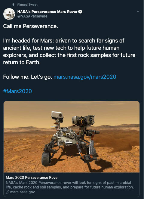
Allow us to reintroduce someone ... the name’s Perseverance.
With this new name, our Mars 2020 rover has now come to life! Chosen by middle school student Alex Mather, Perseverance helps to remind ourselves that no matter what obstacles we face, whether it's on the way to reaching our goals or on the way to Mars, we will push through. In Alex’s own words,
“We are a species of explorers, and we will meet many setbacks on the way to Mars. However, we can persevere. We, not as a nation but as humans, will not give up. The human race will always persevere into the future.”
Welcome to the family. ❤️
Make sure to follow us on Tumblr for your regular dose of space: http://nasa.tumblr.com.
Forecasting D-Day From Above

Image Credit: Department of Transportation. U.S. Coast Guard. Office of Public and International Affairs
It was the raw courage of the more than 160,000 Allied troops who stormed an 80-kilometer (50-mile) stretch of heavily fortified beaches in Normandy, France, that made victory on D-Day possible. But without the sound advice of meteorologists and geologists working behind the scenes, one of the most consequential battles in human history could have gone quite differently.
As D-Day neared, the American meteorologists predicted fair weather on June 5 and pushed for invasion, based on a forecasting method that gave great weight to historical weather conditions for a given date and location. The British forecasters took a different approach, focusing instead on analyzing measurements of temperature, pressure, and humidity to try to map out weather fronts. Unlike the Americans, the British teams predicted low clouds and stormy weather on June 5. At the last minute, Captain James Martin Stagg, the highest ranking of the meteorologists, convinced Eisenhower to postpone the invasion.

NASA Earth Observatory images by Joshua Stevens, using Landsat data from the U.S. Geological Survey
Meanwhile, on the other side of the English Channel, German meteorologists had come to the same conclusion—and then some. Their forecasters had predicted that gale-force winds would arrive on June 5 and persist until mid-June. The Germans were so confident that the Allies would not dare attack that they allowed many soldiers to leave their posts on the beaches and take part in war games in Rennes, France. Field Marshal Erwin Rommel felt comfortable enough to return to Germany to deliver a pair of shoes to his wife as a birthday present.

Image Credit: Department of Defense. Department of the Army. Office of the Deputy Chief of Staff for Operations. U.S. Army Audiovisual Center. ca. 1974-5/15/1984
When the first paratroopers were dropped behind enemy lines around midnight and the first wave of Allied boats began to swarm the beaches at dawn on June 6, the weather was still far from ideal. Cloud cover meant many paratroopers ended up in the wrong locations, and rough seas and high winds made the task of landing boats and unloading tanks a terrible challenge. But by noon the skies cleared, just as the Allied meteorologists had predicted. The Germans, meanwhile, had been caught off guard. That day the Allies endured thousands of causalities, but they established a toehold in France that they would never give up.

NASA Earth Observatory images by Joshua Stevens, using Landsat data from the U.S. Geological Survey
An enormous amount of scientific expertise went into even the most unscientific of tasks, like rolling a tank up the Normandy beaches. Prior to the invasion, Allied military planners studied nearly one million aerial photographs of the shores of Normandy to find the best landing sites. The aerial photographs would have looked something like the Landsat 8 images shown above. Acquired by the Operational Land Imager (OLI) on July 15, 2018, these image offer a top-down view of the sandy Normandy beaches that were center stage on D-Day.
Read the full story: https://earthobservatory.nasa.gov/images/145143/forecasting-d-day
Make sure to follow us on Tumblr for your regular dose of space: http://nasa.tumblr.com.
Ion Propulsion…What Is It?
Ion thrusters are being designed for a wide variety of missions – from keeping communications satellites in the proper position to propelling spacecraft throughout our solar system. But, what exactly is ion propulsion and how does an ion thruster work? Great question! Let’s take a look:

Regular rocket engines: You take a gas and you heat it up, or put it under pressure, and you push it out of the rocket nozzle, and the action of the gas going out of the nozzle causes a reaction that pushes the spacecraft in the other direction.
Ion engines: Instead of heating the gas up or putting it under pressure, we give the gas xenon a little electric charge, then they’re called ions, and we use a big voltage to accelerate the xenon ions through this metal grid and we shoot them out of the engine at up to 90,000 miles per hour.

Something interesting about ion engines is that it pushes on the spacecraft as hard as a single piece of paper pushes on your hand while holding it. In the zero gravity, frictionless, environment of space, gradually the effect of this thrust builds up. Our Dawn spacecraft uses ion engines, and is the first spacecraft to orbit two objects in the asteroid belt between Mars and Jupiter.
To give you a better idea, at full throttle, it would take our Dawn spacecraft four days to accelerate from zero to sixty miles per hour. That may sounds VERY slow, but instead of thrusting for four days, if we thrust for a week or a year as Dawn already has for almost five years, you can build up fantastically high velocity.

Why use ion engines? This type of propulsion give us the maneuverability to go into orbit and after we’ve been there for awhile, we can leave orbit and go on to another destination and do the same thing.
As the commercial applications for electric propulsion grow because of its ability to extend the operational life of satellites and to reduce launch and operation costs, we are involved in work on two different ion thrusters of the future: the NASA Evolutionary Xenon Thruster (NEXT) and the Annular Engine. These new engines will help reduce mission cost and trip time, while also traveling at higher power levels.
Learn more about ion propulsion HERE.
Make sure to follow us on Tumblr for your regular dose of space: http://nasa.tumblr.com
Hurricanes Have No Place to Hide, Thanks to Better Satellite Forecasts

If you’ve ever looked at a hurricane forecast, you’re probably familiar with “cones of uncertainty,” the funnel-shaped maps showing a hurricane’s predicted path. Thirty years ago, a hurricane forecast five days before it made landfall might have a cone of uncertainty covering most of the East Coast. The result? A great deal of uncertainty about who should evacuate, where it was safe to go, and where to station emergency responders and their equipment.

Over the years, hurricane forecasters have succeeded in shrinking the cone of uncertainty for hurricane tracks, with the help of data from satellites. Polar-orbiting satellites, which fly nearly directly above the North and South Poles, are especially important in helping cut down on forecast error.

The orbiting electronic eyeballs key to these improvements: the Joint Polar Satellite System (JPSS) fleet. A collaborative effort between NOAA and NASA, the satellites circle Earth, taking crucial measurements that inform the global, regional and specialized forecast models that have been so critical to hurricane track forecasts.

The forecast successes keep rolling in. From Hurricanes Harvey, Irma and Maria in 2017 through Hurricanes Florence and Michael in 2018, improved forecasts helped manage coastlines, which translated into countless lives and property saved. In September 2018, with the help of this data, forecasters knew a week ahead of time where and when Hurricane Florence would hit. Early warnings were precise enough that emergency planners could order evacuations in time — with minimal road clogging. The evacuations that did not have to take place, where residents remained safe from the hurricane’s fury, were equally valuable.

The satellite benefits come even after the storms make landfall. Using satellite data, scientists and forecasters monitor flooding and even power outages. Satellite imagery helped track power outages in Puerto Rico after Hurricane Maria and in the Key West area after Hurricane Irma, which gave relief workers information about where the power grid was restored – and which regions still lacked electricity.

Flood maps showed the huge extent of flooding from Hurricane Harvey and were used for weeks after the storm to monitor changes and speed up recovery decisions and the deployment of aid and relief teams.

As the 2019 Atlantic hurricane season kicks off, the JPSS satellites, NOAA-20 and Suomi-NPP, are ready to track hurricanes and tropical cyclones as they form, intensify and travel across the ocean – our eyes in the sky for severe storms.
For more about JPSS, follow @JPSSProgram on Twitter and facebook.com/JPSS.Program, or @NOAASatellites on Twitter and facebook.com/NOAASatellites.
Make sure to follow us on Tumblr for your regular dose of space: http://nasa.tumblr.com.
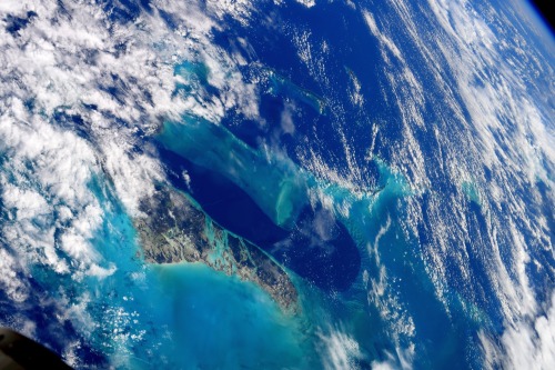
Question: would you rather be on the beach or would you rather gawk at it from space? For some, it’s a tough choice.
Astronaut Soichi Noguchi of the Japan Space Agency recently took this image of Andros Island, the largest island in the Bahamas. He and his three crew mates, NASA astronauts Victor Glover, Mike Hopkins and Shannon Walker, are currently living and working aboard the International Space Station for a six-month science mission. The crew launched on Nov. 15 from Kennedy Space Center and are conducting a number of scientific research, including Earth observation.
Every 90 minutes, the International Space Station completes one orbit around Earth. Because Earth rotates below them while they orbit, the crew get to see most of their beautiful blue marble of a planet from the unique vantage point of space. By photographing Earth from about 250 miles above the surface, astronauts can record phenomena such as storms in real time, and even provide input to ground teams. Make sure to follow us on Tumblr for your regular dose of space: http://nasa.tumblr.com.
-
 sleeping-with-adub liked this · 1 year ago
 -
 mekkyz-dubz reblogged this · 1 year ago
 -
mekkyz-dubz liked this · 1 year ago
-
 ctzenb-u liked this · 1 year ago
 -
 misssickn liked this · 1 year ago
 -
 emibertachini liked this · 1 year ago
 -
 crookedbouquetchopshop liked this · 1 year ago
 -
 maitropnani liked this · 1 year ago
 -
 valleytech09 liked this · 2 years ago
 -
 venussunsett liked this · 3 years ago
 -
 durinsbride liked this · 4 years ago
 -
 0heymoon liked this · 4 years ago
Explore the universe and discover our home planet with the official NASA Tumblr account
1K posts