NASA Does Hurricanes
NASA Does Hurricanes

When you think of NASA, you probably think of space. Which makes sense, because space is a huge part of what we do. That being said, here at NASA we are also involved in many other research areas, and even play a role in hurricane weather forecasting.
Our satellites, computer modeling, instruments, aircraft and field missions all contribute to a mix of information used by scientists to get a better understanding of these storms. Aspects of storms from rainfall rates to surface wind speed are all analyzed to help identify the potential for storm formation or intensification.

Currently, our satellites are passing overhead as Hurricane Joaquin (above) travels through the Atlantic Ocean. Our Global Precipitation Measurement, or GPM Core satellite captured images and rainfall rates of the storm. GPM showed a large area of very intense rain, which indicates that large amounts of heat are being released into the storm’s center. This fuels the circulation and provides the means for its intensification.
Maximum sustained winds have increased to near 80 mph and additional strengthening is expected. Joaquin could become a major hurricane during the next few days.

In 2016, we’re launching the Cyclone Global Navigation Satellite System (CYGNSS), which is a constellation of eight small satellites. With this launch, we will be able to better understand the rapid intensification of hurricanes, and improve hurricane intensity forecasts.
In addition to our satellite technology, we also conduct field missions to study hurricanes. In our most recent field mission, we investigated the process that underlie hurricane formation and intensity change in the Atlantic Ocean basin.
More Posts from Nasa and Others


Image Credit:NASA/JPL-Caltech
In this large celestial mosaic, our Spitzer Space Telescope captured a stellar family portrait! You can find infants, parents and grandparents of star-forming regions all in this generational photo. There’s a lot to see in this image, including multiple clusters of stars born from the same dense clumps of gas and dust – some older and more evolved than others. Dive deeper into its intricacies by visiting https://go.nasa.gov/2XpiWLf
Make sure to follow us on Tumblr for your regular dose of space: http://nasa.tumblr.com.
Exploration in Extreme Environments: Under Water and in Outer Space
Living in the depths of the sea…to prepare for travel in deep space.
Sounds strange, but that’s what our NEEMO expedition aims to do.

This 10-day NASA Extreme Environment Mission Operations (NEEMO) 22 expedition is slated to begin on June 18. NEEMO 22 will focus on both exploration spacewalks (or in this case waterwalks?) and objectives related to the International Space Station and deep space missions.
Analog (noun): is a situation on Earth that produces effects on the body similar to those experienced in space, both physical and mental/emotional. These studies help us prepare for long duration missions.

As an analog for future planetary science concepts and strategies, marine science also will be performed under the guidance of Florida International University’s marine science department.

NASA astronaut Kjell Lindgren will command the NEEMO 22 mission aboard the Aquarius laboratory, 62 feet below the ocean surface near Key Largo Florida. Lindgren was part of the space station Expeditions 44 and 45 in 2015, where he spent 141 days living and working in the extreme environment of space. He also conducted two spacewalks.
Fun Fact: These underwater explorers are referred to as “aquanauts”

Lindgren will be joined by ESA (European Space Agency) astronaut Pedro Duque, Trevor Graff, a Jacobs Engineering employee working as a planetary scientist at our Johnson Space Center; and research scientists Dom D’Agostino from the University of South Florida and the Florida Institute of Human and Machine Cognition.
While living underwater for 10 days, the crew will:
Test spaceflight countermeasure equipment
Validate technology for precisely tracking equipment in a habitat
Complete studies of body composition and sleep
Assess hardware sponsored by ESA that will help crew members evacuate someone who has been injured on a lunar spacewalk

Why do we use Analog Missions?
Analog missions prepare us for near-future exploration to asteroids, Mars and the moon. Analogs play a significant role in problem solving for spaceflight research.
Not all experiments can be done in space – there is not enough time, money, equipment and manpower
Countermeasures can be tested in analogs before trying them in space. Those that do not work in analogs will not be flown in space
Ground-based analog studies are completed more quickly and less expensively
For more information about the NEEMO mission, visit: https://www.nasa.gov/mission_pages/NEEMO/index.html
Make sure to follow us on Tumblr for your regular dose of space: http://nasa.tumblr.com
Solar System: Things to Know This Week
Our Juno mission has been exploring Jupiter since July 2016 with a special passenger on board: JunoCam, an instrument designed to take spectacular close-up color images of the largest planet in our solar system. From the raw images, citizen scientists have processed a range of beautiful photographs that highlight Jupiter's features, even turning them into works of art. Below, 10 stunning images JunoCam has given us over the past year.
1. Jovian tempest.

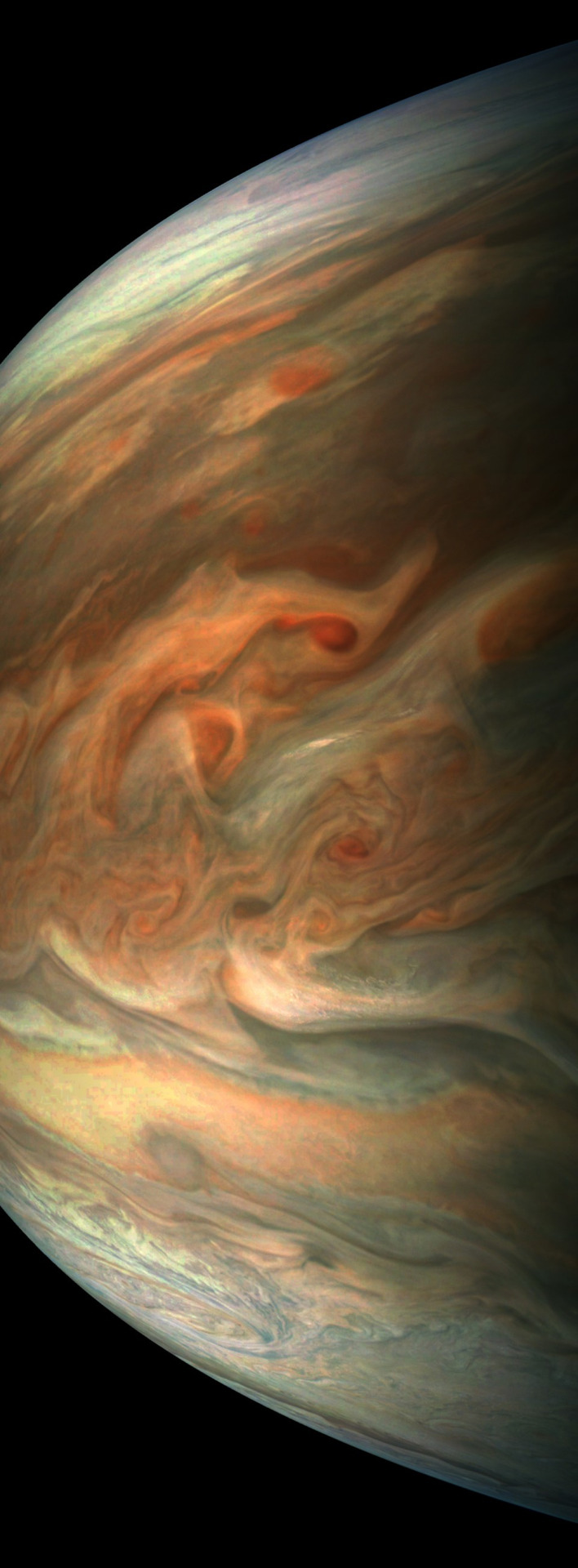
This color-enhanced image of a massive, raging storm in Jupiter's northern hemisphere was captured by our Juno spacecraft during its ninth close flyby on Oct. 24, 2017. The storm is rotating counter-clockwise with a wide range of cloud altitudes, and the darker clouds are expected to be deeper in the atmosphere than the brightest clouds.
2. A southern stunner.

Jupiter's southern hemisphere shows off in beautiful detail in this image taken on Oct. 24, 2017. The color-enhanced view captures one of the white ovals in the "String of Pearls," one of eight massive rotating storms at 40 degrees south latitude on the gas giant planet.
3. Dreaming in color.

Artist Mik Petter created this unique digital piece using data from the JunoCam. The art form, known as fractals, uses mathematical formulas to create an infinite variety of form, detail, color and light. The original JunoCam image was taken on July 10, 2017.
4. Jovian moon shadow.

Jupiter's moon Amalthea casts a shadow on the gas giant planet in this image taken on Sept. 1, 2017. The elongated shape of the shadow is a result of both the location of the moon with relation to Jupiter in this image as well as the irregular shape of the moon itself.
5. 95 minutes over Jupiter.

Once every 53 days, Juno swings close to Jupiter, speeding over its clouds. In about two hours, the spacecraft travels from a perch over Jupiter's north pole through its closest approach (perijove), then passes over the south pole on its way back out. This sequence shows 11 color-enhanced images from Perijove 8 (Sept. 1, 2017) with the south pole on the left (11th image in the sequence) and the north pole on the right (first image in the sequence).
6. Soaring high.
This striking image of Jupiter was taken on Sept. 1, 2017 as Juno performed its eighth flyby. The spacecraft was 4,707 miles (7,576 kilometers) from the tops of the clouds of the planet at a latitude of about -17.4 degrees. Noteworthy: "Whale's Tail" and "Dan's Spot."
7. In true color.
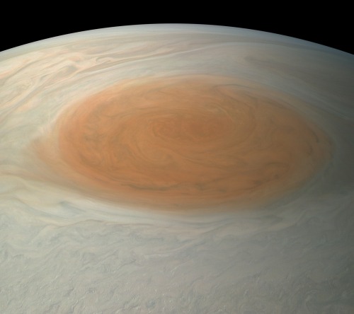
This true-color image offers a natural color rendition of what the Great Red Spot and surrounding areas would look like to human eyes from Juno's position. The image was taken on July 10, 2017 as the Juno spacecraft performed its seventh close flyby of Jupiter.
8. The 'face' of Jupiter.

JunoCam images aren't just for art and science—sometimes they're created for a good chuckle. This image, processed by citizen scientist Jason Major, is titled "Jovey McJupiterface." By rotating the image 180 degrees and orienting it from south up, two white oval storms turn into eyeballs, and the "face" of Jupiter is revealed. The original image was taken by the Juno spacecraft on May 19, 2017.
9. Bands of clouds.

This enhanced-color image of Jupiter's bands of light and dark clouds was created by citizen scientists Gerald Eichstädt and Seán Doran. Three of the white oval storms known as the "String of Pearls" are visible near the top of the image. Each of the alternating light and dark atmospheric bands in this image is wider than Earth, and each rages around Jupiter at hundreds of miles (kilometers) per hour. The lighter areas are regions where gas is rising, and the darker bands are regions where gas is sinking. Juno captured the image on May 19, 2017.
10. The edge.

This enhanced-color image of a mysterious dark spot on Jupiter seems to reveal a Jovian "galaxy" of swirling storms. Juno captured this image on Feb. 2, 2017 and citizen scientist Roman Tkachenko enhanced the color to bring out the rich detail in the storm and surrounding clouds. Just south of the dark storm is a bright, oval-shaped storm with high, bright, white clouds, reminiscent of a swirling galaxy. As a final touch, he rotated the image 90 degrees, turning the picture into a work of art.
To learn more about the Juno mission at Jupiter, visit: www.nasa.gov/juno.
Follow the Juno mission on Facebook, Instagram and Twitter.
Make sure to follow us on Tumblr for your regular dose of space: http://nasa.tumblr.com.
5 Things: How Hurricanes Have Changed Puerto Rico’s Forests
In September 2017, Hurricanes Irma and Maria hit Puerto Rico, knocking out critical infrastructure and ransacking the island’s forests. In April and May 2018, a team of our scientists took to the air to take three-dimensional images of Puerto Rico’s forests using Goddard’s Lidar, Hyperspectral, and Thermal Imager (G-LIHT), which uses light in the form of a pulsed laser. By comparing images of the same forests taken by the team before and after the storm, scientists will be able to use those data to study how hurricanes change these important ecosystems.
Here are five ways scientists say the hurricanes have changed Puerto Rico’s forests since making landfall eight months ago:
1. The Canopy Is Bare

One word defines the post-hurricane forest canopy in El Yunque National Forest: Open.
“The trees have been stripped clean,” said NASA Goddard Earth scientist and G-LiHT co-investigator Doug Morton. He was there a year ago, months before the hurricanes would ravage the area. When he returned to the forest in April 2018 to gather measurements of trees on the ground to complement the airborne campaign’s lidar work, he could now see from the mountainside downtown San Juan, which is 45-minutes away by car.
And no canopy means no shade. “Where once maybe a few flecks of sunlight reached the forest floor, now the ground is saturated in light,” Morton said, adding that such a change could have profound consequences for the overall forest ecosystem. For example, some tree seedlings that thrive on a cool forest floor may whither now that daytime temperatures are as much as 4 degrees Celsius (7 degrees Fahrenheit) hotter than they were before the hurricane. Meanwhile, as we shall see, other plants and animals stand to benefit from such changes.
“Who are the winners and losers in this post-hurricane forest ecosystem, and how will that play out in the long run? Those are two of the key questions,” said Morton.
2. Palms Are on the Rise

One species that’s basking in all that sunlight is the Sierra Palm, said Maria Uriarte, a professor of ecology at Columbia University who has researched El Yunque National Forest for 15 years. “Before, the palms were squeezed in with the other trees in the canopy and fighting for sunlight, and now they’re up there mostly by themselves,” she said. “They’re fruiting like crazy right now.”
The secret to their survival: Biomechanics.
“The palm generally doesn’t break because it’s got a flexible stem—it’s got so much play,” Uriarte said. “For the most part, during a storm it sways back and forth and loses its fronds and has a bad hair day and then it’s back to normal.” By contrast, neighboring trees with very dense, strong wood, like the Tabonuco, were snapped in half or completely uprooted by the force of the hurricane winds.
“Palm trees are going to be a major component of the canopy of this forest for the next decade or so,” added Doug Morton. “They’ll help to facilitate recovery by providing some shade and protection as well as structure for both flora and fauna.”
3. Vines Are Creeping Opportunists

Rising noticeably from the post-Hurricane forest floor of El Yunque National Forest are woody vines called lianas. Rooted in the ground, their goal, Morton says, is to climb onto host trees and compete for sunlight at the top. That, combined with the fact that their weight tends to slow tree productivity potential, means they are literally a drag on the forest canopy. As lianas can wind their way around several trees, regions with more of these vines tend to have larger groupings of trees that get pulled down together.
“There’s some indication that vines may be more competitive in a warmer, drier, and more carbon dioxide-rich world,” Morton said. “That’s a hypothesis we’re interested in exploring.”
4. Endangered Parrot Populations Have Taken a Hit

The endangered Iguaca is the last living native parrot species of Puerto Rico. The island’s two Iguaca aviaries have reported a substantial number of deaths in the wild due to the hurricanes. In the forests of Río Abajo, in western central Puerto Rico, about 100 of the roughly 140 wild parrots survived; in El Yunque National Forest in the eastern part of the island, only three of the 53 to 56 wild parrots are known to have pulled through.
“It was a huge blow,” said the U.S. Fish and Wildlife Service’s Tom White, a parrot biologist stationed at the aviary in El Yunque, which took the brunt of Hurricane Maria’s Category 5 winds. Some of the parrots died from injuries received during the storm, while others likely died from increased predation from hawks because there were no longer canopies for them to hide in. The rest succumbed to starvation. The Iguaca subsists on flowers, fruits, seeds, and leaves derived from more than 60 species—but for several months following the storm, the forest was completely defoliated.
Despite the setback, White said he’s optimistic that the Iguaca will rebound. In Río Abajo, the number of wild Iguaca are enough that they should rebound on their own; in El Yunque there are about 227 birds at the aviary—a strong number for continued breeding and eventual release into the forest once conditions improve enough. “One of their main fruit comes from the sierra palm, and they’re now flowering and starting to produce again,” White noted. “It’s probably going to take about another year for things to level out, but the forest is gritty.”
5. Lizards and Frogs: A Mixed Response
When Hurricane Maria stripped the leaves off of trees, changes in the forest microclimate instantly transformed the living conditions for lizards and frogs. Species have reacted differently to the event based on the conditions they are adapted to, said herpetologist Neftali Ríos-López, an associate professor at the University of Puerto Rico-Humacao Campus.

For example, some lizard species are naturally suited to the forest canopy, which is warmer and drier. “After the hurricane, those conditions, which were once exclusive to the canopy, have now been extended down to the forest floor,” Ríos-Lopez said. “As a result, these lizards start displacing and substituting animals that were adapted to the once cooler conditions on the forest floor.”

Likewise, among frog species the red-eyed coquí, with its resistance to temperature and humidity fluctuations and its ability to handle dehydration better than other coquí species, has benefited from the warmer, drier conditions in the forests after the storm. Traditionally a grassland species, they are expanding from the lowlands to the mid- and even high parts of the mountains, Ríos-Lopez said. “Physiologically, what was a disadvantage for that species when the whole island was forested now finds itself in a positive position.” Conversely, forest-acclimated coquí frog species have declined.
That said, as the forests recover, so will many of the species whose numbers have dwindled following the storms. “It will take many years, decades, I would guess,” Ríos-Lopez said.
Our scientists are working with partners from universities and government to use G-LiHT airborne data to inform ground research on forest and other ecosystems not only in Puerto Rico but also throughout the world. To follow their campaigns and keep up with the latest news, find them here: https://gliht.gsfc.nasa.gov.
Make sure to follow us on Tumblr for your regular dose of space: http://nasa.tumblr.com.
A Total Lunar Eclipse is Coming: 10 Things to Know
If you were captivated by August's total solar eclipse, there's another sky show to look forward to on Jan. 31: a total lunar eclipse!

Below are 10 things to know about this astronomical event, including where to see it, why it turns the Moon into a deep red color and more...
1. First things first. What's the difference between solar and lunar eclipses? We've got the quick and easy explanation in this video:
2. Location, location, location. What you see will depend on where you are. The total lunar eclipse will favor the western U.S., Alaska, Hawaii, and British Columbia on Jan. 31. Australia and the Pacific Ocean are also well placed to see a major portion of the eclipse, if not all of it.

3. Color play. So, why does the Moon turn red during a lunar eclipse? Here's your answer:
4. Scientists, stand by. What science can be done during a lunar eclipse? Find out HERE.
5. Show and tell. What would Earth look like from the Moon during a lunar eclipse? See for yourself with this artist's concept HERE.
6. Ask me anything. Mark your calendars to learn more about the Moon during our our Reddit AMA happening Monday, Jan. 29, from 3-4 pm EST/12-1 pm PST.

7. Social cues. Make sure to follow @NASAMoon and @LRO_NASA for all of the latest Moon news leading up to the eclipse and beyond.
8. Watch year-round. Can't get enough of observing the Moon? Make a DIY Moon Phases Calendar and Calculator that will keep all of the dates and times for the year's moon phases right at your fingertips HERE.

Then, jot down notes and record your own illustrations of the Moon with a Moon observation journal, available to download and print from moon.nasa.gov.
9. Lesson learned. For educators, pique your students' curiosities about the lunar eclipse with this Teachable Moment HERE.
10. Coming attraction. There will be one more lunar eclipse this year on July 27, 2018. But you might need your passport—it will only be visible from central Africa and central Asia. The next lunar eclipse that can be seen all over the U.S. will be on Jan. 21, 2019. It won't be a blue moon, but it will be a supermoon.
Make sure to follow us on Tumblr for your regular dose of space: http://nasa.tumblr.com.

Take a good look: this is the black hole at the center of our galaxy.
In the inset image, gas in the glowing orange ring surrounds the black hole's event horizon, a boundary from which nothing can escape. The ring is created by light bending in the intense gravity around Sagittarius A*, which has a mass some four million times greater than our Sun. This groundbreaking image of Sagittarius A* was taken by the Event Horizon Telescope team with data from telescopes around the world. After the EHT's iconic image of M87*, released in 2019, this is only the second time a supermassive black hole has been directly observed with its shadow.
The wider look at the space around Sagittarius A* includes data contributed by several NASA missions. The orange specks and purple tendrils were captured in infrared light by the Hubble Space Telescope, and the blue clouds represent data from our orbiting Chandra X-ray Observatory.
Fall in to the whole story: https://www.nasa.gov/mission_pages/chandra/images/sagittarius-a-nasa-telescopes-support-event-horizon-telescope-in-studying-milky-ways.html
Make sure to follow us on Tumblr for your regular dose of space!
CREDIT: X-ray: NASA/CXC/SAO; IR: NASA/HST/STScI. Inset: Radio (EHT Collaboration)
Do you have any messages or tips for other girls who want to study and work in STEM fields?
Does an ecplispe cause any unusual effects on the Earth?
Yes, and this is one of the things we’re hoping to study more with this eclipse! If you are in totality, you’ll notice a significant temperature drop. We are also expecting to see changes in the Earth’s atmosphere and ionosphere. You can help us document these changes using the GLOBE Observer app https://www.globe.gov/globe-data/data-entry/globe-observer ! There are lots of great citizen science going on during this eclipse, and we’d love to have everyone here helping out! https://eclipse2017.nasa.gov/citizen-explorers
What's your opinion on astronaut food?
Unveiling the Center of Our Milky Way Galaxy

We captured an extremely crisp infrared image of the center of our Milky Way galaxy. Spanning more than 600 light-years, this panorama reveals details within the dense swirls of gas and dust in high resolution, opening the door to future research into how massive stars are forming and what’s feeding the supermassive black hole at our galaxy’s core.

Among the features coming into focus are the jutting curves of the Arches Cluster containing the densest concentration of stars in our galaxy, as well as the Quintuplet Cluster with stars a million times brighter than our Sun. Our galaxy’s black hole takes shape with a glimpse of the fiery-looking ring of gas surrounding it.
The new view was made by the world’s largest airborne telescope, the Stratospheric Observatory for Infrared Astronomy, or SOFIA.
Make sure to follow us on Tumblr for your regular dose of space: http://nasa.tumblr.com.
-
 sweetbutterbliss liked this · 2 weeks ago
 -
 nat8choa liked this · 5 years ago
 -
 salmalootfi liked this · 5 years ago
 -
 avionicstek liked this · 7 years ago
 -
 radiocimarrona liked this · 8 years ago
 -
 m00ndingochan liked this · 8 years ago
 -
 riybham liked this · 8 years ago
 -
 temporal-index reblogged this · 9 years ago
 -
 cakefat reblogged this · 9 years ago
 -
 dotmpotter reblogged this · 9 years ago
 -
 book-choco-loco reblogged this · 9 years ago
 -
 warlocksandwizards reblogged this · 9 years ago
 -
 freequency reblogged this · 9 years ago
 -
 silvermorningglory reblogged this · 9 years ago
 -
 lebenskraft reblogged this · 9 years ago
 -
 smitten-owl liked this · 9 years ago
 -
 lovebug052712-blog reblogged this · 9 years ago
 -
 michmeetsworld reblogged this · 9 years ago
 -
 jam-bo-blog liked this · 9 years ago
 -
 shiningbangtan-blog liked this · 9 years ago
 -
 paranormal2things liked this · 9 years ago
 -
 artificialoving liked this · 9 years ago
 -
 itslenysrios-blog liked this · 9 years ago
 -
 raiining liked this · 9 years ago
 -
 sharkie335 reblogged this · 9 years ago
 -
 calmiranda-blog reblogged this · 9 years ago
 -
calmiranda-blog liked this · 9 years ago
-
 zoerussle liked this · 9 years ago
 -
 stalkerosity liked this · 9 years ago
 -
 oceanusamor liked this · 9 years ago
 -
 myloadedgodcomplex reblogged this · 9 years ago
 -
myloadedgodcomplex liked this · 9 years ago
-
 eudaimonia-inbln liked this · 9 years ago
 -
 xxstone reblogged this · 9 years ago
 -
 soapbubbles54 liked this · 9 years ago
Explore the universe and discover our home planet with the official NASA Tumblr account
1K posts